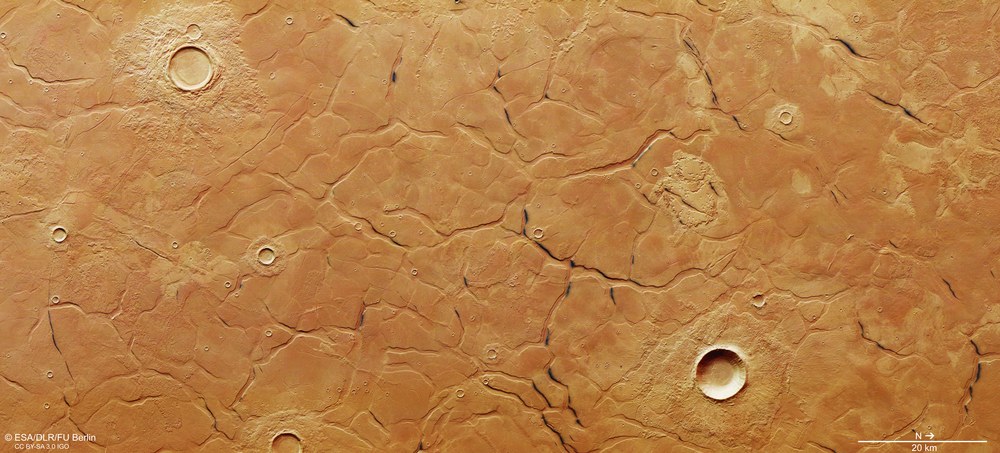
View of the fracture system in the Utopia Planitia impact basin
This colour image was created from the nadir channel oriented perpendicular to the surface of Mars and the colour channels of the HRSC.
It shows a network of huge fractures in Utopia Planitia. New research results link the formation of these huge ‘polygons’ in this region to the previous existence of an ocean in the Martian Northern Lowlands.
Some of the graben show dark deposits stretching along their upper edges. It is conceivable that these are dark, fine-grained ash layers emerging. They are the source of the widespread black sand dunes on Mars.
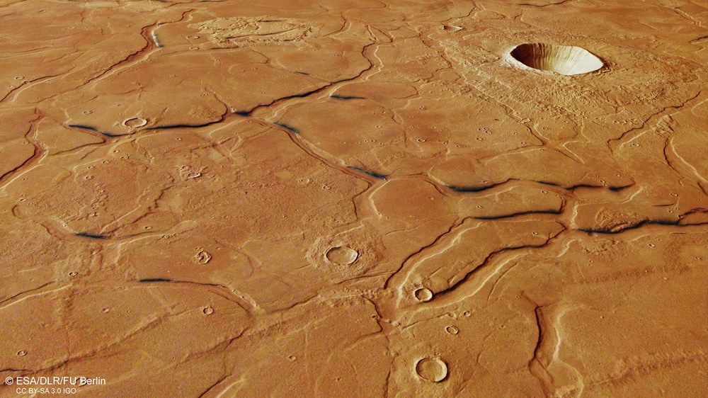
Perspective view of the fracture system in Utopia Planitia
This perspective angle view was calculated by the stereo channels of the High Resolution Stereo Camera operated by the German Aerospace Center on board the European Mars Express spacecraft.
A network of huge fractures covers the buried impact basin of Utopia Planitia. It measures 2000 kilometres in diameter and is located in the Martian Northern Lowlands. These surface structures, referred to as polygons, would suggest that an ocean once existed here.
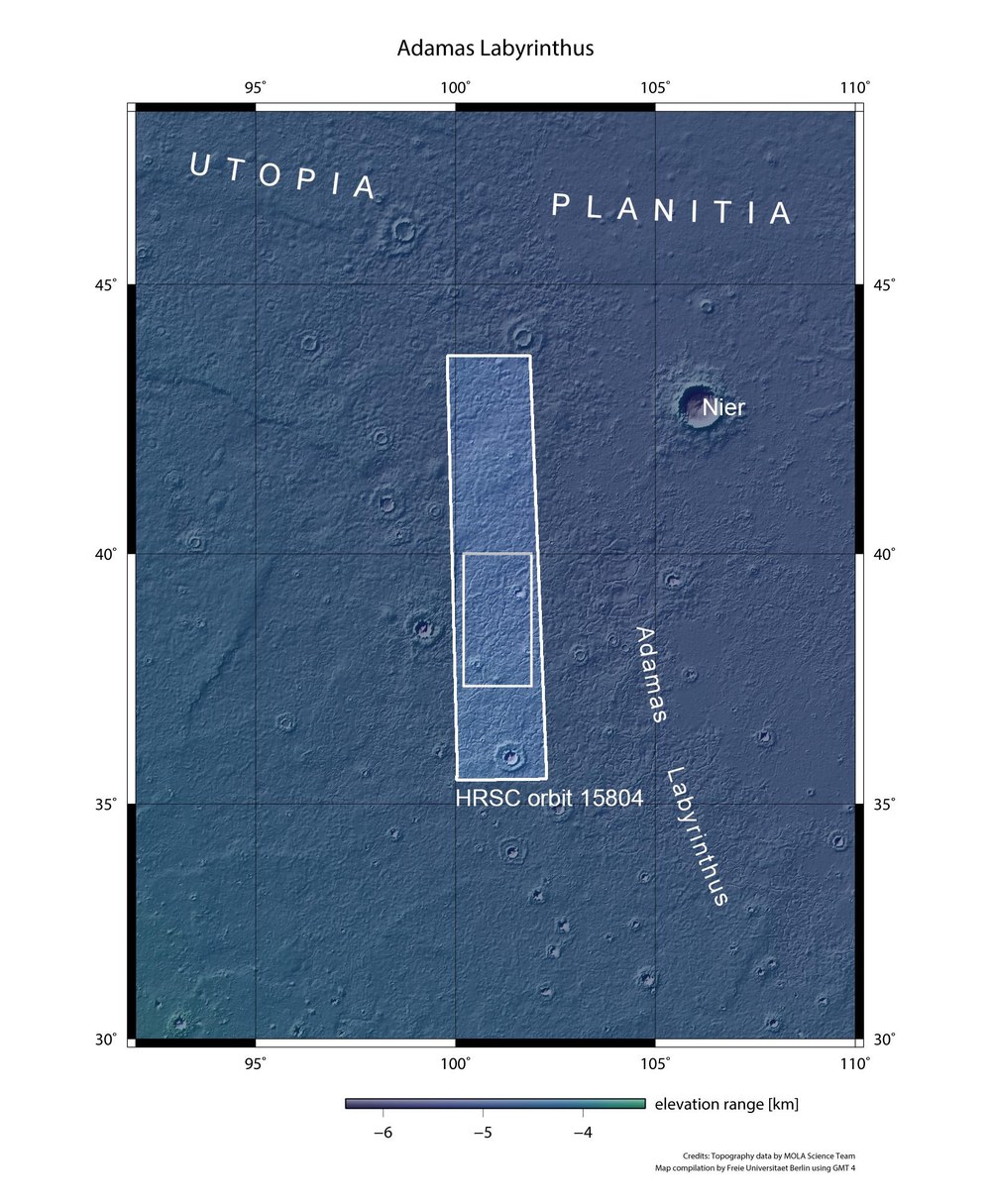
Topographical context map of a part of the Utopia Planitia region
The images were acquired by the High Resolution Stereo Camera (HRSC) during Mars Express Orbit 15,804 on 21 June 2016. The image resolution is 15 metres per pixel. The centre of the image is located at 101 degrees east and 39 degrees north.
The network of huge fractures in the Utopia Planitia region is linked to the past existence of an ocean in the Northern Lowlands of Mars.
A network of huge fractures covers Utopia Planitia – a buried impact basin measuring 2000 kilometres in the Martian Northern Lowlands, which was the destination of the United States Viking 2 lander in 1976. These surface structures, which are referred to as polygons, would suggest that there was once an ocean here.
The images shown here were acquired on 21 June 2016 by the High Resolution Stereo Camera (HRSC) operated by the German Aerospace Center (Deutsches Zentrum für Luft- und Raumfahrt; DLR) on board the European Mars Express spacecraft. The labyrinth-like fracture system seen on the images consists of graben up to two kilometres wide that run back and forth and form polygon-shaped structures between five and 20 kilometres in diameter.
Giant polygons, 'pancake-shaped' ejecta blankets and dark graben
New results link the formation of these huge polygons in the Utopia Planitia region to the former existence of an ocean in the Martian Northern Lowlands. It is conceivable that the polygons (Latin for 'many-sided structures') formed in fine-grained sediments covering a rough basement.
Fine-grained sediments such as mud, for example, are deposited in large bodies of water such as oceans. In the past, the surface – now covered by sediment – could have been just as uneven as the Southern Highlands of Mars. At a later point in time, the surface was subjected to tectonic processes. The polygons are similar in morphology and size to polygons on Earth, which form in fine-grained deposits in shallow seawater when the water is displaced.
Some impact craters can also be seen in the images. The shape of the ejecta blankets around the craters in this region can be described as pancake-like. This shape indicates that ice and/or water was present in the subsurface at the time of impact. This then melted or escaped upon impact and mixed with the material that was catapulted out, so that a muddy mass flowed out of the crater.
Some of the graben show dark deposits stretching along their upper edges. It is conceivable that these are emerging dark, fine-grained ash layers that are the source of the widespread black sand dunes on Mars. It is also striking that these dark lines occur mainly on the side of the slope facing the Sun. Scientists therefore assume that the emergence of the ash layers from below the cover layer of ice, debris and dust was facilitated by solar radiation. Accordingly, the ice sublimated on the heated slopes, thereby allowing the covering layer of debris and dust, which was no longer held in place, to slip off or be worn away. As a result, the ash layer appeared.
Image processing
The images were acquired by the High Resolution Stereo Camera (HRSC) during Mars Express Orbit 15,804 on 21 June 2016. The image resolution is 15 metres per pixel. The centre of the image is at about 101 degrees east and 39 degrees north. The colour view was created from the nadir channel oriented perpendicular to the surface of Mars and the colour channels of the HRSC; the perspective angle view was calculated from the HRSC stereo channels. The anaglyph image, which conveys a three-dimensional impression of the landscape when viewed with red-blue or red-green glasses, was derived from the nadir channel and one stereo channel. The view, encoded in rainbow colours, is based on a digital terrain model of the region from which the topography of the landscape can be derived. The reference unit for the HRSC-DTM is a Martian globe.
The HRSC experiment
The High Resolution Stereo Camera was developed at the German Aerospace Center (Deutsches Zentrum für Luft- und Raumfahrt; DLR) and built in collaboration with partners in industry (EADS Astrium, Lewicki Microelectronic GmbH and Jena-Optronik GmbH). The science team, which is headed by principal investigator (PI) Ralf Jaumann, consists of over 40 co-investigators from 33 institutions and ten countries. The camera is operated by the DLR Institute of Planetary Research in Berlin-Adlershof. The images shown here were generated by the Institute of Geological Sciences at FU Berlin in conjunction with the DLR Institute of Planetary Research in Berlin.
