DLR's High Resolution Stereo Camera 'flies' over a future Mars landing site – Jezero Crater
Your consent to the storage of data ('cookies') is required for the playback of this video on Quickchannel.com. You can view and change your current data storage settings at any time under privacy.
ESA/DLR/FU Berlin, CC BY-SA 3.0 IGO
- The video shows a simulated overflight over the landing site of the Perseverance rover of NASA's Mars 2020 mission, which is located in the Jezero crater, where a crater lake existed more than 3.5 billion years ago.
- The overflight was created using image data from DLR's High Resolution Stereo Camera (HRSC) on board ESA's Mars Express mission.
- The digital terrain model of the HRSC on which this flight is based has made an important contribution to the exploration and selection of this landing site.
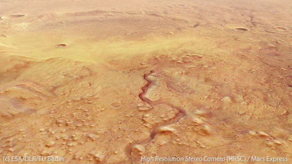
Jezero is not just any impact crater on Mars. An ancient river delta near the western rim of the crater is evidence that it contained a lake more than 3.5 billion years ago. Numerous aqueous minerals prove that liquid water must have been present in it for a very long time – one of the most important prerequisites for life. This is why Jezero Crater is the destination of NASA’s Mars 2020 mission, which is scheduled to launch on 30 July 2020 at 13:50 CEST and which will begin searching for traces of life in the former crater lake in February 2021.
This simulated overflight was created using image data acquired by DLR’s High Resolution Stereo Camera (HRSC) on board ESA's Mars Express orbiter and digital terrain models derived from this data. It shows an area at approximately 18 degrees north and 77 degrees east.
Jezero Crater is located on the northwestern edge of Isidis Planitia, one of the largest impact basins on Mars. Some of the oldest and most interesting geological formations and rocks on Mars can be found in its immediate vicinity. The crater has a diameter of approximately 45 kilometres, and its heavily eroded rim is breached to the west and east by inflow and outflow channels respectively. Lakes of this type are referred to ‘open basin lakes’, which means that water continuously flows in and out of them. They are fed primarily by surface water.
The inflow channel, with its transported sediments, created a river delta whose mineralogical composition attracted the attention of scientists. It contains more than just clay minerals rich in aluminium together with iron and magnesium – which were formed by the chemical weathering of the original rock in the presence of liquid water; these are often found elsewhere on Mars. Instead, it also contains carbonate minerals that are common on Earth in limestone or dolomite and could have been formed in the lake itself. The interesting thing about carbonate minerals formed in a lake is that they are particularly capable of preserving macro- and microscopic biosignatures – that is, organic molecules or even fossilised microorganisms – over billions of years. NASA's Mars 2020 mission will use intensive and complex chemical investigations and sampling to investigate whether life once originated in this crater lake. In addition, 43 rock and soil samples will be sealed in containers that are planned to be returned to Earth by the early 2030s for precise analysis.
A short flight guide
As it approaches Jezero Crater, the 'flight' first passes over the outflow channel from the east; this is where the water from the lake flowed into the surrounding terrain. Then the ‘observer’ can see a yellow marking showing the landing ellipse, which measures approximately 10 kilometres across. This is where the Mars 2020 rover ‘Perseverance’ will be set down in February 2021 by a sky crane, in a similar manner to its predecessor rover, 'Curiosity'. The ellipse partially encompasses the river delta, which geomorphologists refer to as a ‘bird foot delta’, because the arrangement of its broad channels resembles the outstretched claws of a bird. Through the meandering valley Neretva Vallis, which breaks through the crater wall from the west, a river flowed until about 3.8 billion years ago; the sediments transported by this river formed the delta. The crater is now very shallow because it has been extensively filled by lake sediments and material carried in by the wind. The rim of Jezero Crater now only rises about 1000 metres above its floor.
HRSC contribution
The underlying digital terrain model, created using data acquired by HRSC, has made an important contribution to research into and the selection of this landing site. It was created at DLR and Freie Universität Berlin at the request of the Mars 2020 project and evaluated together with the Jet Propulsion Laboratory (JPL) for landing site selection and for the development of the navigation systems for the landing. However, geological questions can also be answered with such precise data from the stereo camera. In addition to the depth and volume of the crater lake, it is also possible, for example, to estimate the water flow rates of the rivers. For this purpose, the width, depth and gradient of the riverbeds are related to the properties of the underlying rock.
Precise, high-resolution topographical maps derived from HRSC data, computed by scientists from DLR and Freie Universität Berlin and made available to NASA and ESA, were and are indispensable for the selection of landing sites. They have been used for earlier (Spirit, Opportunity, Phoenix) and current missions (Curiosity, InSight). They have more recently been employed for Mars missions that will be launched in 2020 and 2022 and then land seven months later (Mars 2020/Perseverance and ExoMars/Rosalind Franklin).
ESA is currently examining whether the Mars Express mission, on which the HRSC camera has been orbiting for more than 16 years, could and should be extended for the eighth time.
- Image processing
This simulated flyover was created using data from the High Resolution Stereo Camera (HRSC) on board ESA's Mars Express mission. The video is derived from an image mosaic constructed using four orbital strips (0988, 2228_2, 5252, 5270) combined with topographic information from the HRSC stereo channels to create a three-dimensional model of the landscape. Finally, this Martian landscape was imaged from different angles, similar to the techniques employed by a convention cinematic camera, and the overflight was computed. - The HRSC experiment on Mars Express
The High Resolution Stereo Camera was developed at the German Aerospace Center (DLR) and built in cooperation with industrial partners (EADS Astrium, Lewicki Microelectronic GmbH and Jena-Optronik GmbH). The science team, led by the Principal Investigator (PI) Ralf Jaumann, consists of 51 Co-Investigators from 35 institutions and 11 nations. The camera is operated by the DLR Institute of Planetary Research in Berlin-Adlershof, where the systematic processing of the camera data is also carried out. Staff at the Department of Planetary Sciences and Remote Sensing at Freie Universität Berlin used the data to create the image products shown here.