Blurred craters on Mars – traces of former glaciation in the southern highlands
October 29, 2020 | Mars Express mission
Blurred craters on Mars – traces of former glaciation in the southern highlands
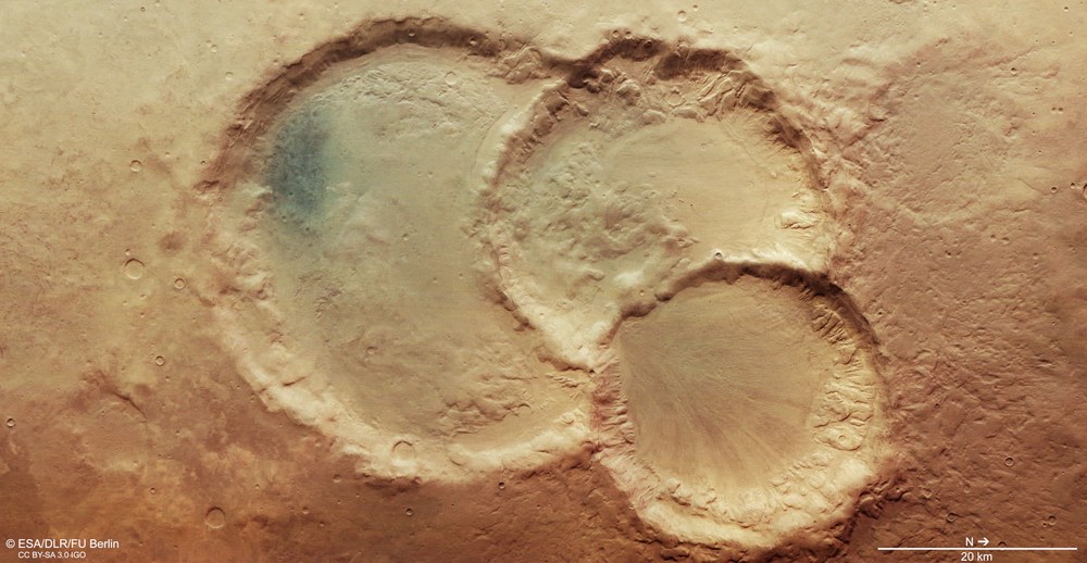
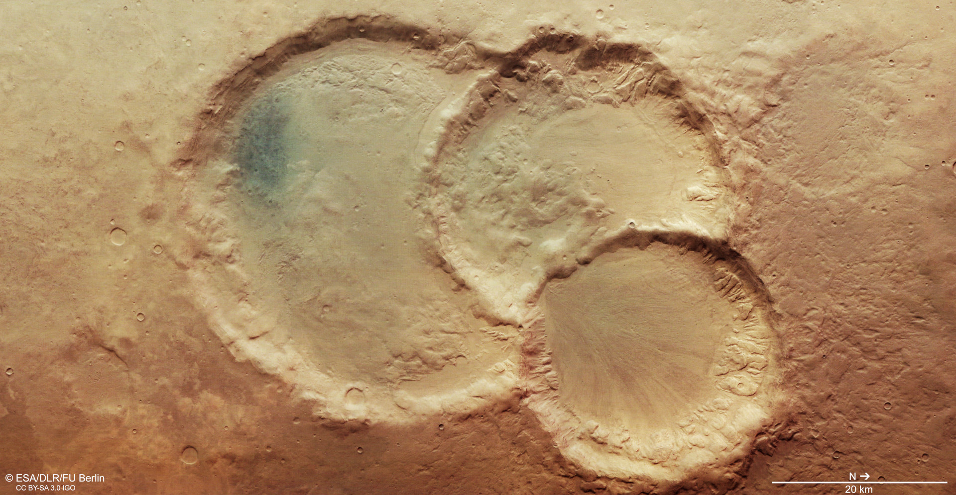
View of a crater triplet in the Noachis Terra region on Mars
The image shows three superimposed impact craters. The largest of them measures 45 kilometres across, the middle one approximately 34 and the smallest 28. One scenario for the formation of the crater triplet be that a meteoroid broke into at least three pieces on entering the Martian atmosphere before all three bodies successively hit the surface. However, it could also be a coincidence that three impactors hit Mars independently at almost the same position and over a somewhat greater time interval.
Signs of glacial activity in a crater triplet on the southern highlands of Mars
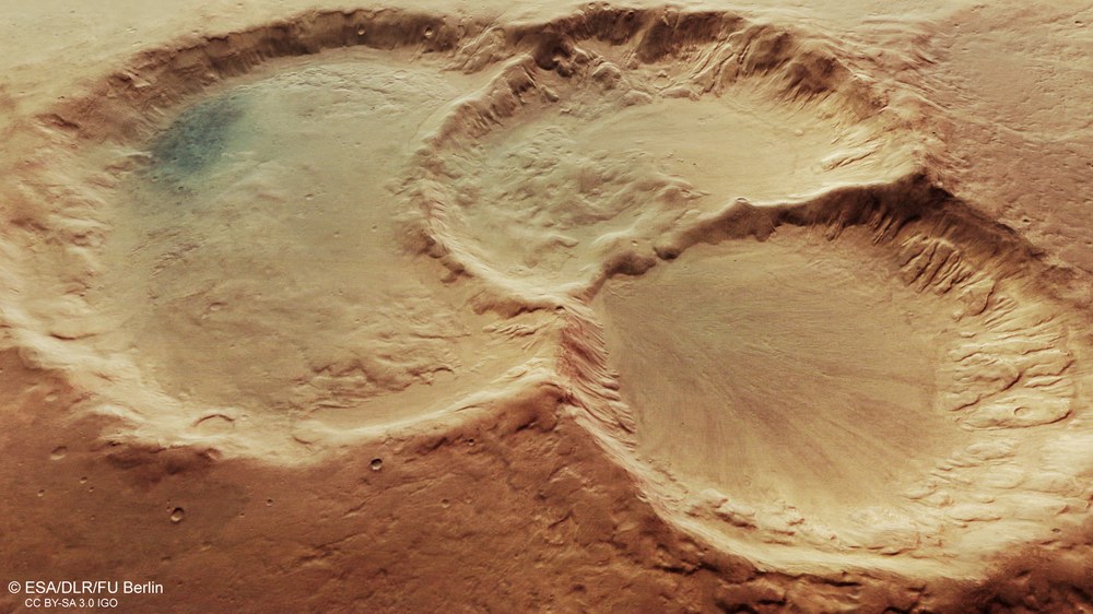
The oblique perspective view into the crater triplet, located in the Noachis Terra region, clearly shows the flow traces of rock glaciers at the bottom of the crater. The dark patch in the largest crater represents a small accumulation of dark sands, which elsewhere on Mars form numerous impressive dune fields. Especially in the two craters on the right-hand side of the image, deeply incised gullies testify to the erosive activity of flowing water.
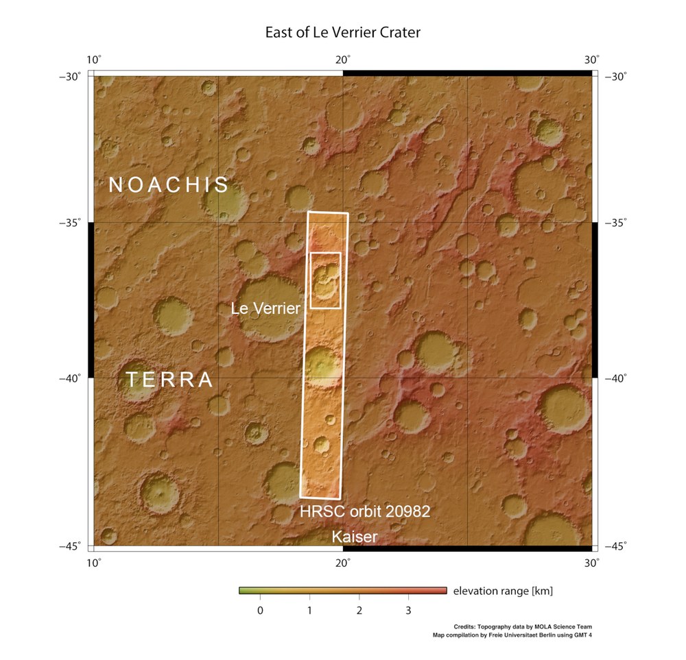
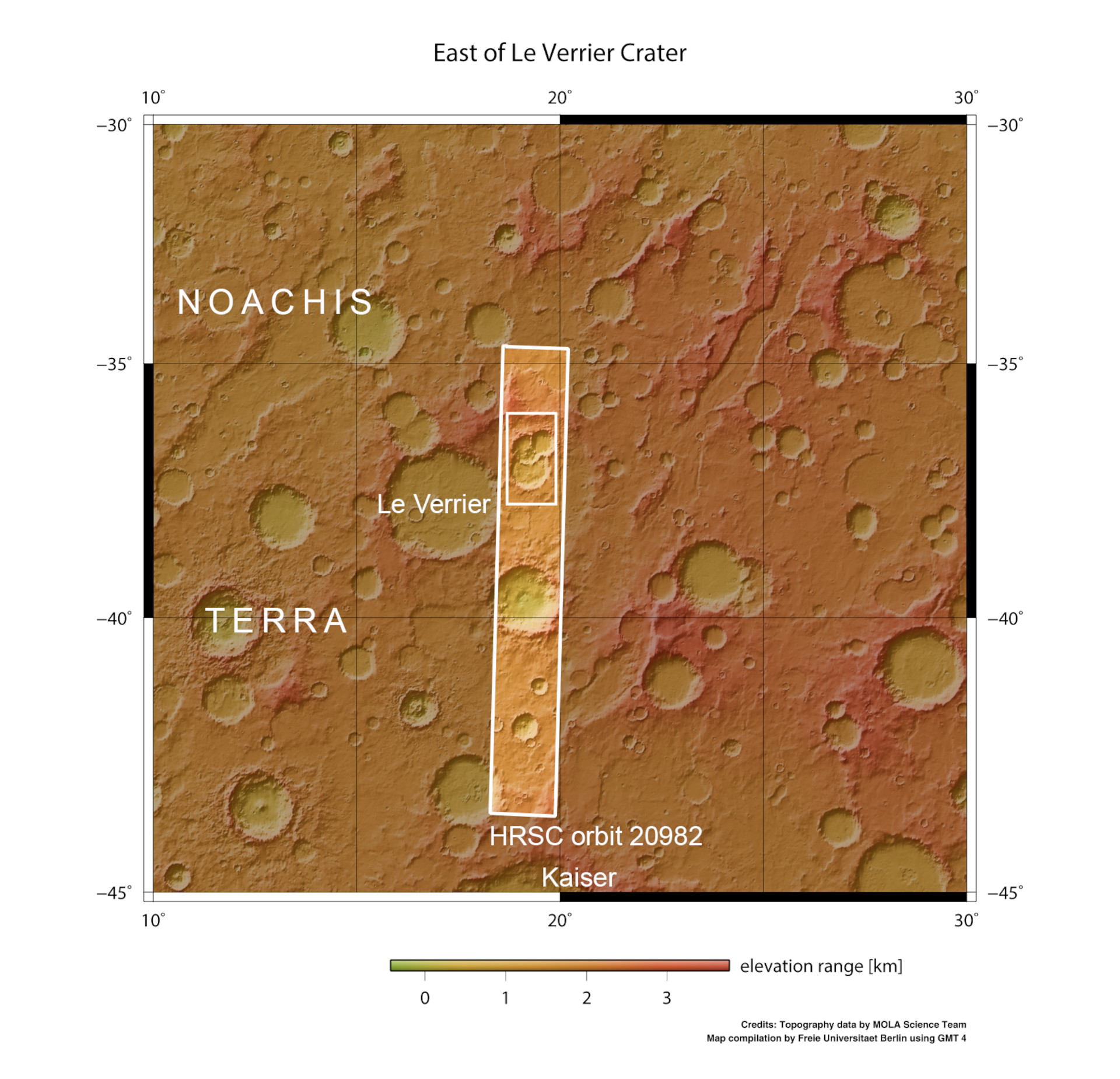
Topographic overview map of the surroundings of a crater triplet in Noachis Terra
The High Resolution Stereo Camera (HRSC) operated by the German Aerospace Center (Deutsches Zentrum für Luft- und Raumfahrt; DLR) imaged a crater triplet in the southern highland region of Noachis Terra on 6 August 2020 during Mars Express orbit 20,982. The southern hemisphere has a significantly higher number of impact craters than the northern hemisphere, testimony to its greater age.
These images of Mars, acquired by the DLR-operated HRSC instrument, show a crater triplet in the Noachis Terra region in the southern highlands of Mars.
The southern hemisphere has a significantly higher number of impact craters than the northern hemisphere, testimony to its greater age.
Some of the impact craters in this region appear to have 'melted' and almost become flattened, which can be explained by flow movements of ice beneath the surface.
HRSC has been mapping the Red Planet in unprecedented resolution, in three dimensions and in colour, since 2004 – as part of ESA's Mars Express mission.
Focus: Space, planetary research, Mars
These High Resolution Stereo Camera (HRSC) images show a rare crater triplet, located in the Noachis Terra region in the southern highlands of Mars. HRSC has been mapping the Red Planet in unprecedented resolution, in three dimensions and in colour, since 2004 as part of ESA's Mars Express mission. It was developed at the German Aerospace Center (Deutsches Zentrum für Luft- und Raumfahrt; DLR) and built in cooperation with German industry. It is operated by the DLR Institute of Planetary Research. In addition to global topography, Mars Express provides new data on the geology, mineralogy and atmosphere of Mars, in order to gain insights into the climate history of our neighbouring planet and to clarify the role of water and the location of the water that is still present.
Age, formation and geology
The highland regions of the southern hemisphere of Mars are covered with impact craters. The craters are much more numerous than in the northern hemisphere, which proves that these regions are among the oldest on the planet. One of these regions is called Noachis Terra and gave its name to the Noachian Period, an epoch that lasted from approximately 4.1 to 3.7 billion years ago and was marked by a strong bombardment by meteorites and asteroids. In this early phase of the planet, large regions were topographically shaped, hence the name Noah, after the ark builder in the Old Testament. The images show three superimposed impact craters. The largest of them measures 45 kilometres across, the middle one approximately 34 and the smallest 28. One scenario for the formation of the craters could be that a meteoroid broke into at least three pieces before all three bodies hit the surface of Mars in succession.
However, it could also be a coincidence that three impactors hit Mars independently at almost the same location over a somewhat longer time interval. Due to the fact that there are still residues of its ejecta blanket around the smallest crater, it is obvious that this smaller crater was formed after the two larger ones. Their ejecta blankets have long since been eroded and blurred. At the northern rim of the crater triplet (top right in images 1, 3, 4) another small, circular structure is visible, possibly representing a fourth, now filled impact crater.
Craters filled with sediment and ice
Like many other impact craters in the southern highlands, these three craters show typical rims that have already been smoothed out by erosion, as well as shallow and fairly flat crater floors, indicating that they are filled with sediment. Parts of the crater walls seem to have 'melted' and sunk into the centre of the crater depression, and numerous wide gullies cut through the slopes. Particularly striking are the linear structures in the northernmost crater (lower right in images 1, 3, 4). Its surface morphology resembles that of terrestrial block or debris glaciers, which are common in alpine and polar regions.
This typical flow structure was formed when a mixture of debris and ice from a glacier in the crater flowed downhill to the centre of the crater triplet at a breakthrough in the inner crater rim. The debris traces the movements of the plastic ice flow in the subsurface. This is particularly visible on the colour-coded elevation model (image 3). The dark patch in the largest crater represents a small accumulation of dark sands, which form numerous and quite impressive dune fields elsewhere on Mars.
Smooth terrain
The plain around the impact craters, which also has a smooth, flat surface, shows interesting landscape features. It is not covered by countless small and medium-sized impact craters, as one would expect for a surface of this age on Mars. Secondary craters, which are formed when ejected material hits the area around a newly formed crater, are not visible either. Only a handful of bowl-shaped, lightly eroded and therefore young craters can be found there. It appears that craters older than a certain age have been subject to 'melting' and that many of the smaller and medium-sized impact craters that were even older have disappeared as a result. Ice in the Marian subsurface seems to have played the key role in this levelling process.
Given enough time, smaller surface structures formed on an ice-rich surface may also 'melt' again due to the flow of the ice, breaking down to a certain extent and smoothing the surface again. The process, which is typical of glacial activity on Mars, is referred to as 'terrain softening'. This observation shows that there were once large quantities of water on Mars. They created glacier-like flow structures with very large ice masses, especially during the Noachian Period. Today, most of the glacier ice has long since sublimed and left the debris masses it carried with it as witnesses of its flow processes, similar to glacial moraines on Earth. However, ground ice is still abundant on Mars today. It was first detected in 2008 by NASA’s Phoenix lander in the high latitudes of the northern lowlands.
These images were acquired by the High Resolution Stereo Camera (HRSC) on 6 August 2020 during Mars Express orbit 20,982. The image resolution is approximately 15 metres per pixel. The centre of the images is located at about 19 degrees east and 37 degrees south. The perpendicular colour view was generated using data acquired by the nadir channel, the field of view which is aligned perpendicular to the surface of Mars, and the colour channels of HRSC. The oblique perspective view was computed using a Digital Terrain Model (DTM) and data acquired by the nadir and colour channels of HRSC. The anaglyph, which provides a three-dimensional view of the landscape when viewed using red-green or red-blue glasses, was derived from data acquired by the nadir channel and the stereo channels. The colour-coded topographic view is based on a DTM of the region, from which the topography of the landscape can be derived. The reference body for the HRSC DTM is a Mars equipotential surface (Areoid).
HRSC was developed and is operated by the German Aerospace Center (Deutsches Zentrum für Luft- und Raumfahrt; DLR). The systematic processing of the camera data was performed at the DLR Institute of Planetary Research in Berlin-Adlershof. Personnel at the Department of Planetary Sciences and Remote Sensing at Freie Universität Berlin used these data to create the image products shown here.
The HRSC experiment on Mars Express
The High Resolution Stereo Camera (HRSC) was developed by the German Aerospace Center (Deutsches Zentrum für Luft- und Raumfahrt; DLR) and built in collaboration with partners in industry (EADS Astrium, Lewicki Microelectronic GmbH and Jena-Optronik GmbH). The science team, which is headed by Principal Investigator (PI) Ralf Jaumann, consists of 52 co-investigators from 34 institutions in 11 countries. The camera is operated by the DLR Institute of Planetary Research in Berlin-Adlershof.
