Hauptinhalt überspringenNavigation überspringenFooter überspringen
  • DLR Portal
  • Presse
  • Barrierefreiheit
deen
DLR Logo
Institut für Robotik
und Mechatronik
  • Über uns

    • ▾Das Institut für Robotik und Mechatronik
      • ▾Geschichte des Instituts
      • ▾360-Grad-Tour
      • ▾Institutsleitung
    • ▾Abteilungen
      • ▾Mechatronische Systeme
      • ▾Analyse und Regelung komplexer Robotersysteme
      • ▾Autonomie und Fernprogrammierung
      • ▾Perzeption und Kognition
      • ▾Kognitive Robotik
      • ▾Institutsentwicklung und Zentrale Aufgaben
    • ▾Ansprechpersonen
      • ▾Standort & Anreise
      • Forschung

        • ▾Robotersysteme
          • ▾Forschungsanlagen
          • ▾Arme
          • ▾Flugroboter
          • ▾Hände und Greifer
          • ▾Humanoide
          • ▾Laufroboter
          • ▾Mehrarmige Systeme
          • ▾Mobile Plattformen
          • ▾Mensch-Maschine-Schnittstellen
          • ▾Systemkomponenten
          • ▾Scanner
        • ▾Anwendungsfelder
          • ▾Raumfahrtassistenzrobotik
          • ▾Orbitale Robotik
          • ▾Planetare Explorationsrobotik
          • ▾Produktion der Zukunft
          • ▾Terrestrische Assistenz
          • ▾Geländerobotik
        • ▾Expertise
          • ▾Autonomie
          • ▾3D-Wahrnehmung
          • ▾Regelung
          • ▾Modellierung
          • ▾Telepräsenz und VR
          • ▾Terramechanik
          • ▾Archiv
        • ▾Projekte & Missionen
          • ▾Laufende Projekte
          • ▾Abgeschlossene Projekte
        • ▾Wissenschaftliche Publikationen
          • ▾Literatur
          • ▾Software
          • ▾Datensätze
      • Innovation & Transfer

        • ▾Erfolgsgeschichten
          • ▾Sensodrive
          • ▾Roboception
          • ▾MIRO Innovation Lab
          • ▾Hugo: Weltraumtechnologie für den OP
        • ▾Ausgründungen
          • ▾3D-Input
          • ▾Agile Robots
          • ▾Blickfeld
          • ▾Elektra Solar
          • ▾Kastanienbaum
          • ▾Kinetik Space
          • ▾Kinfinity
          • ▾Leverage Robotics
          • ▾Roboception
          • ▾RoboDrive
          • ▾Sensodrive
          • ▾tacterion
          • ▾Tilo Wüsthoff Industrial Design
          • ▾Wessling Robotics
          • ▾Versatile Robotics
      • Aktuelles

        • ▾Nachrichten
          • ▾2025
          • ▾2024
          • ▾2023
          • ▾2022
          • ▾2021
          • ▾Archiv
        • ▾Pressespiegel
        • Medien

          • ▾Bilder
            • ▾Videos
              • ▾Broschüren
              • Karriere & Nachwuchs

                • ▾Stellenangebote am Institut
                  • ▾Informationen für Studierende
                  >
                  Forschung
                  >
                  Expertise
                  >
                  Archiv
                  >
                  >
                  Vision
                  >
                  Reconstruction
                  Startseite
                  >
                  Forschung
                  >
                  Expertise
                  >
                  Archiv
                  >
                  Vision
                  >
                  Reconstruction

                  Reconstruction

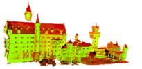
                  Terrain and city modeling from aerial images

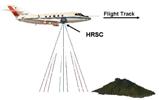
                  Aerial images can be acquired relative quickly and with ground resolutions of down to a few cm per pixel. Usually, cameras are pre-calibrated and the position and orientation at each imaging position is measured during the flight by differential GPS and IMU sensors. For several applications, it is useful or required to reconstruct the scene and integrate all individual images into one consistent, large image.

                  Stereo Algorithms

                  The world has three spatial dimensions. Pictures contain only two spatial dimensions. One dimension (i.e. the depth or distance from the camera) is lost when the light from the scene is projected onto the two dimensional image. This depth can be recovered by using two or more images of the same scene from different viewpoints.

                  Registration

                  For the 3D reconstruction inside historic buildings, we need a marker-free automatic registration approach to align different views together, because GPS does not work indoors and markers are not allowed to paste on the walls. We present an automatic matching process, which employs a novel algorithm, Dynamic Matching Tree technique, for a fast and stable coarse-matching to achieve the automatic pre-alignment of two point clouds and uses modified ICP to do a fine matching efficiently.

                  DLR logo
                  Institut für Robotik
                  und Mechatronik
                  DLR Logo
                  Institut für Robotik
                  und Mechatronik

                  Münchener Straße 20 82234 Oberpfaffenhofen-Weßling

                  Kontakt

                  • Kontaktformular

                  Über die Website

                  • Barrierefreiheit
                  • Datenschutzerklärung
                  • Datenschutz-Einstellungen (Cookies)
                  • Impressum & Nutzungsbedingungen
                  Besuchen Sie uns hier:
                  Besuchen Sie uns auf YouTube