Accurate air pollution measurements – the Sentinel-5P data service commences operations
July 11, 2018
Accurate air pollution measurements – the Sentinel-5P data service commences operations
Ozone hole over the Antarctic
The Sentinel-5P mission will produce a complete global atmospheric composition dataset over the course of each day. The DLR Earth Observation Center (EOC) creates different products from the data, which are made available no later than three hours after the measurements were performed. The example here shows the distribution of ozone over the southern hemisphere on 9–10 November 2017. The very thin ozone layer (blue) over the Antarctic is particularly noticeable.
Comparison of resolutions – TROPOMI / Sentinel-5P and GOME-2 / MetOp
The TROPOMI instrument on board Sentinel-5P has a spatial resolution of 7 by 3.5 kilometres, surpassing comparable satellites by a factor of 100. For comparison, the graphic shows the spread of the sulphur dioxide cloud from the Sierra Negra volcano on 27 June 2018. On the left is the measurement result from TROPOMI / Sentinel-5P and on the right the result from the EUMETSAT MetOp-A and MetOp-B satellites.
The image contains modified Copernicus Sentinel data (2018), processed by DLR / BIRA.
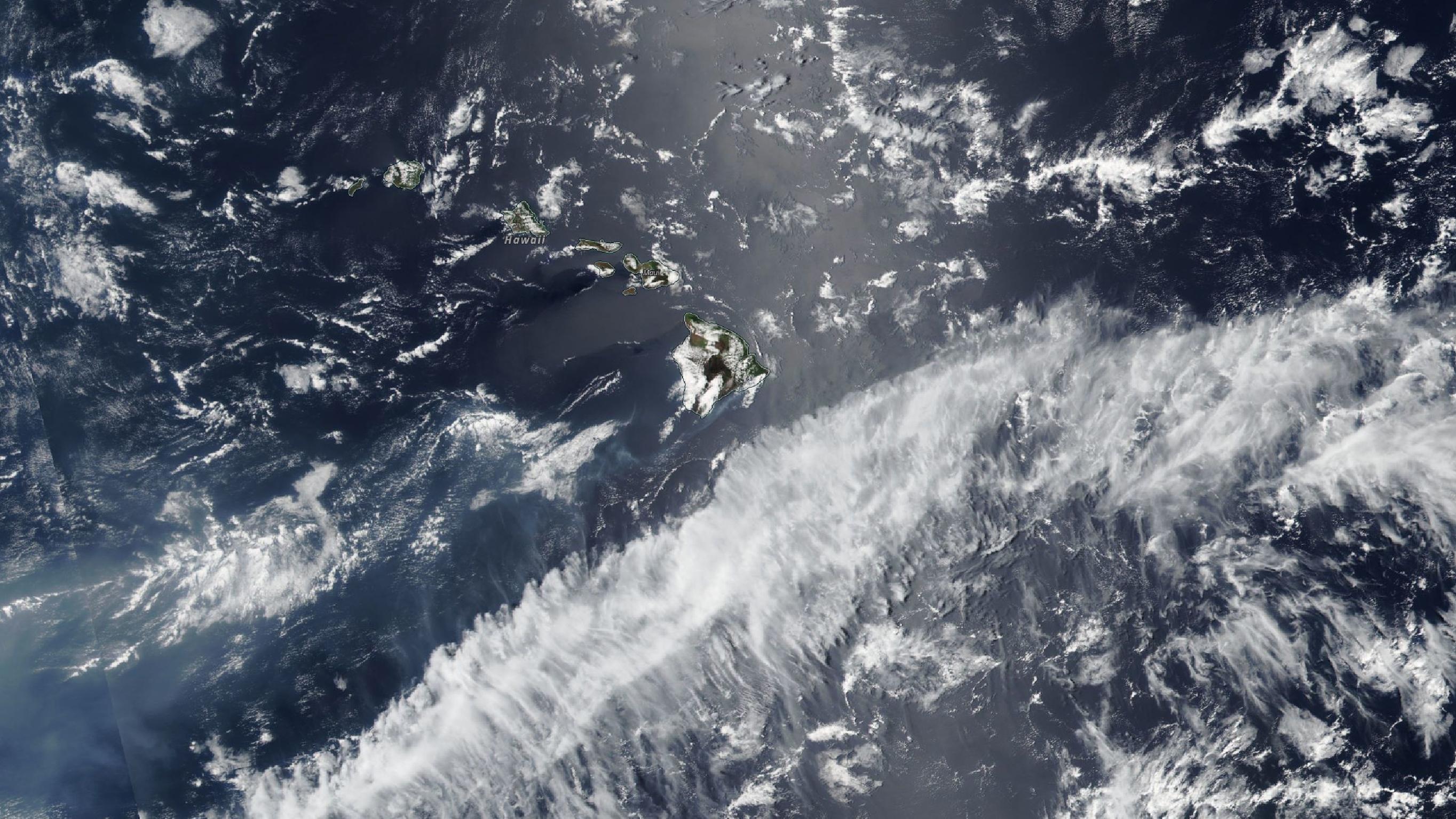
Optical sensors cannot penetrate through clouds or other visual barriers, so their view of Earth is often limited. This image of Hawaii was acquired by the Moderate Resolution Imaging Spectroradiometer (MODIS), which is carried on NASA’s Terra and Aqua satellites.
Daily global measurements of ozone, nitrogen dioxide,carbon monoxide, aerosol and cloud properties
The DLR Earth Observation Center (EOC) is responsible for the payload data ground segment of the Sentinel-5P mission as well as for the analysis of the satellite data together with KNMI.
Focus: Space, Earth Observation, Big Data
Air pollution is one of the biggest threats to health worldwide. Around seven million people die as a result of pollutants every year, as the World Health Organization (WHO) has recently established in a global study. Industrial fumes and exhaust emissions from cars and other vehicles make a significant contribution to the number of deaths, as the particles penetrate deep into people’s airways, lungs and cardiovascular system. There is now a special service that can pinpoint sources of pollution precisely and analyse global pollutant distributions from space.
The European Sentinel-5 Precursor Earth observation satellite provides daily global measurements of ozone, nitrogen dioxide, carbon monoxide, and aerosol and cloud properties. The data gathered by the TROPOspheric Monitoring Instrument (TROPOMI) instrument are freely available. Decision-makers, environmental authorities and scientists rely on high-precision data products to better understand and combat global challenges such as air pollution and climate change. The German Aerospace Center (Deutsches Zentrum für Luft- und Raumfahrt; DLR) is responsible for the payload data ground segment of the Sentinel-5P mission and, together with the Royal Netherlands Meteorological Institute (Koninklijk Nederlands Meteorologisch Instituut; KNMI), is responsible for analysing the satellite data.
In the coming months the Sentinel-5P service will continue to expand, with global analysis products for sulphur dioxide, formaldehyde, tropospheric ozone, ozone profiles, methane and aerosol layer heights. This information not only assists with atmospheric and climate research and health care, but is also used in the field of aviation safety, to better predict volcanic ash clouds.
On 26 June 2018, shortly before the end of its test phase, the surveillance satellite quickly detected the eruption of the Sierra Negra volcano on the Galápagos Islands. At around 20:12 local time (02:12 UTC on 27 June), Sentinel-5P detected extremely high concentrations of sulphur dioxide over the volcano, and was able to determine the spread of the gas cloud with great accuracy.
Complex processing, unparalleled quality
With a spatial resolution of 3.5 kilometres by 7 kilometres, the TROPOMI multispectrometer outperforms comparable systems by a factor of 100. For the first time, air pollution from individual cities and built-up areas can be detected from space. The satellite orbits Earth 14 times a day with complementary orbits. Whether they relate to ozone levels or sulphur dioxide concentrations, the individual data products are made available within three hours of the measurements being taken. This service, which operates almost in real time, is technically demanding, but crucial for users, as change processes in the atmosphere often occur very fast. Overall, Sentinel-5P provides a complete global dataset for atmospheric composition every day.
The complex technical processes required to produce a total of 12 end products with a daily data volume of up to two terabytes makes the Sentinel-5P mission unique. The TROPOMI measurements move through a highly complex processing chain, whereby the raw spectral data are received by the ground station in the Arctic and transmitted to DLR via global fibre-optic links. Then, they are analysed, filtered, processed into individual data products and automatically made available on a web server. The DLR Earth Observation Center (EOC) and KNMI developed the processing system. DLR runs the processors and ensures that the complex work steps run smoothly. In addition to TROPOMI data, the results of measurements performed by international partner organisations, which are constantly being received by the EOC in Oberpfaffenhofen, are integrated into the products. Remote sensing experts can thus ensure that their evaluations are highly accurate and up to date at a global level.
Open web service and secure data transmission
The various Sentinel-5P products are made available via the Sentinels Scientific Data Hub, an ESA data portal. Special users, such as the European Centre for Medium-Range Weather Forecasts (ECMWF), are also given special access to the data by the EOC, to ensure immediate data provision. In addition, DLR is currently working on its own supplementary Sentinel-5P products via the ‘EOC Geoservice’. This open web service is designed to enable users to view or download the data for selected regions in different projections and data formats, or to integrate them directly into their own systems.
Data management is vital to ensure that the atmospheric data can be used at any point in the future. The EOC is responsible for the long-term archiving of the data for Sentinel-5P, as it is for other missions in the European Copernicus programme. In view of these new challenges, the DLR facility recently expanded the capacity of its data library by 60 petabytes.
Thanks to its special infrastructure and long-standing experience, the EOC has also been entrusted with the payload ground segment for Sentinel-5P, from setup to operation. This means that DLR’s experts are now responsible for all data traffic, from initial receipt, processing and data management all the way through to the dissemination and long-term storage of valuable Earth observation products.
The TROPOMI data reception is realised by a consortium consisting of DLR, the Norwegian company Kongsberg Satellite Services (KSAT) and the Swedish Space Corporation (SSC). The consortium is using the polar ground stations Svalbard in Norway and Inuvik in Canada. DLR operates its own receiving station on the grounds of the Inuvik Satellite Station Facility (ISSF) of the Canada Centre for Mapping and Earth Observation (CCMEO).
The global communication networks for science and research Cybera, CANARIE, Uninett, NORDUnet, GÉANT and DFN, which form the backbone of data transmission, contribute to meeting near-real-time requirements. The commissioning of the 1154-kilometere Mackenzie Valley Fibre Link through the Canadian Arctic in June 2017 was also very important.
About the mission
The Sentinel-5P satellite was launched on 13 October 2017. The Sentinel-5P mission was developed within the scope of the European Copernicus Earth-observation programme by the European Space Agency (ESA) and the Netherlands Space Office (NSO), as was the scientific payload, the TROPOMI instrument. The satellite data is analysed by the Royal Netherlands Meteorological Institute (KNMI) and the German Aerospace Center (DLR). The mission is supported by the ESA Member States, the NSO and the European Union.
Copernicus – The European Earth observation programme
The Sentinel satellites belong to the European Union's Copernicus programme. Its purpose is to collect and analyse remote sensing data of Earth. The information is used by government agencies, companies, the scientific community and interested citizens.
Copernicus consists of six satellite families, known as the Sentinels, which map the Earth and its atmosphere and therefore provide important data for climate protection, sustainable development, humanitarian aid and civilian security, as well as on the condition of the oceans, landmass and vegetation. Measuring devices on the ground, in the air and in bodies of water add to the satellite data.
The European Space Agency (ESA) and the European Organisation for the Exploitation of Meteorological Satellites (EUMETSAT) operate the 20 environmental satellites. The German Federal Ministry for Transport and Digital Infrastructure (BMVI) is in charge of the German contribution to Copernicus. The German Aerospace Center (DLR) looks after the programme in Germany.
German partners in industry and research
Sentinel-5P is a cooperation between the Netherlands and ESA, which carries 40 percent of the costs. In addition, companies domiciled in Germany, among them Airbus Defence & Space in Friedrichshafen, have contributed key components of the satellite (mass storage and radiant cooler) and of the monitoring instrument TROPOMI. Important parts of the instrument and platform were built by various German companies – for instance STI GmbH (solar cells) and ZARM Technik AG. The DLR Earth Observation Centerin Oberpfaffenhofen, which built the payload ground segment that it operates on behalf of the ESA, is also involved in the Sentinel missions and therefore contributes to the Copernicus programme. A consortium comprising DLR, the University of Bremen and the Max Planck Institute for Chemistry in Mainz built the scientific data processing systems.

