August 17, 2022 | New service shows daily fire extent and intensity
Satellites keep an eye on burnt areas in Europe
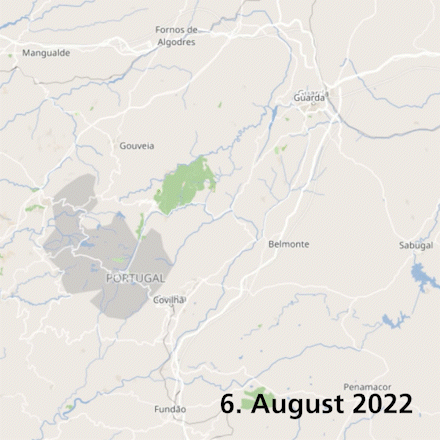
Situation in Portugal from 6 to 16 August 2022
The overview shows the development of a forest fire in Portugal north of Covilha from 6 to 16 August 2022. The orange and red areas show regions where the fire was particularly intense.
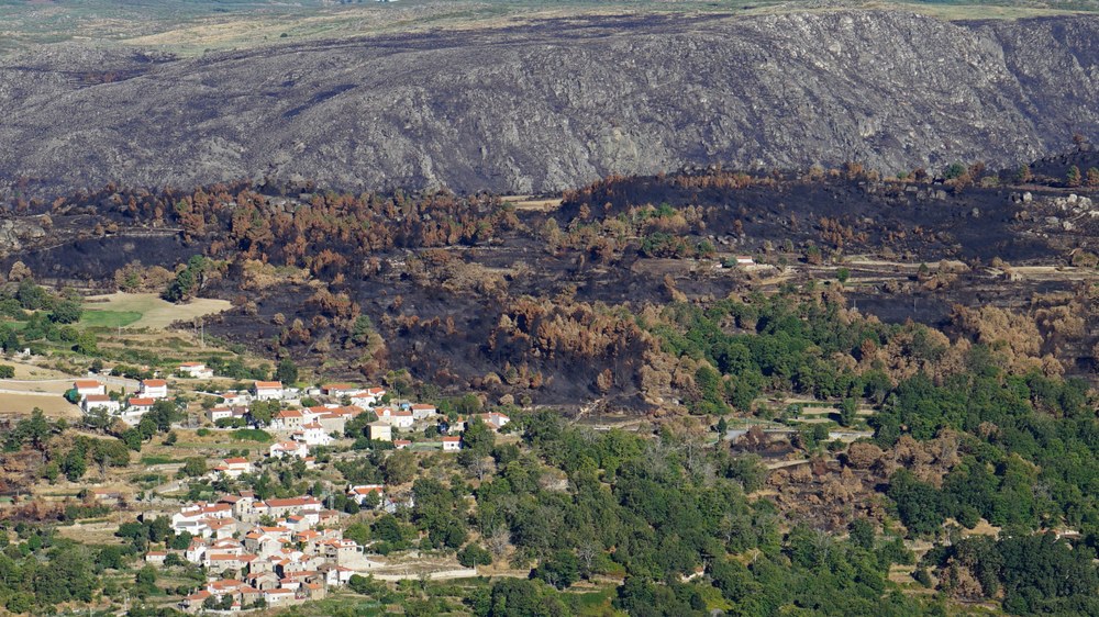
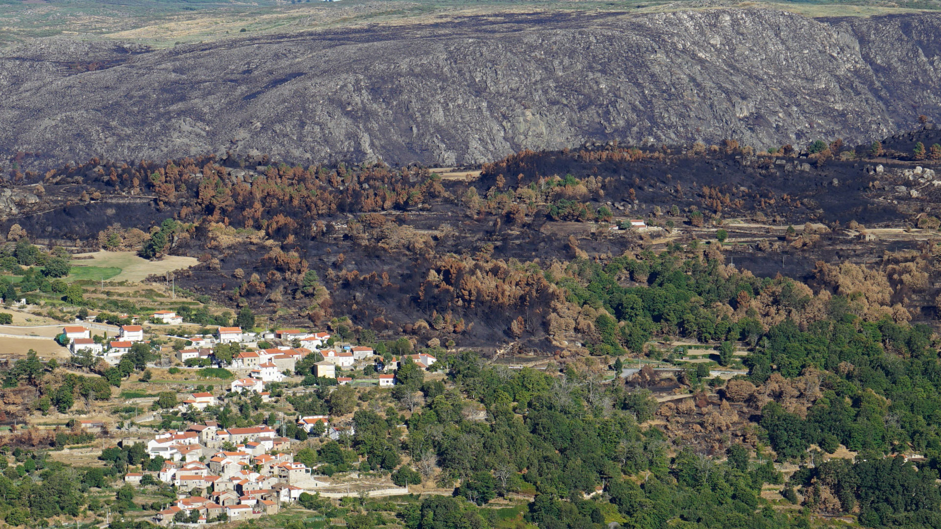
Portugal was particularly affected by forest fires in 2016 and 2017. The image shows a burnt area in Portugal in 2016 and a settlement in the immediate vicinity. In 2016, a total area of 145,079 hectares burned in the western European country. In 2017, it was 339,525 hectares.
Satellite data show the full extent of the forest fires currently blazing across Europe. The German Aerospace Center (Deutsches Zentrum für Luft- und Raumfahrt; DLR) is offering a new service to monitor developments on a daily basis and over time. The satellite data are automatically evaluated and plotted on a map. This Fire Monitoring System from the Center for Satellite-based Crisis Information (Zentrum für satellitengestützte Kriseninformation; ZKI) is available now and can be used free of charge.
"We are not only able to identify the location of a fire, but also the extent to which the vegetation has been affected. Among other things, this is important for estimating the resulting emissions," says group leader Torsten Riedlinger of the German Remote Sensing Data Center (Deutsche Fernerkundungsdatenzentrum; DFD) in Oberpfaffenhofen. For example, for a large fire south of the French city of Bordeaux, which was particularly affected last week the satellites detected a burnt area of nearly 8100 hectares. "This was a particularly severe fire that destroyed a dense forest area. We can determine this using a special indicator that shows the burnt biomass," Riedlinger explains.
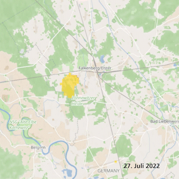
45 major fires in Germany since the beginning of July
Fire departments in Germany are also battling forest fires fuelled by the extreme drought. According to the ZKI Fire Monitoring System, there have been 45 major fires in Germany since the beginning of July. Several thousand hectares of forest, scrubland and pastureland have been destroyed. The most severe fires occurred in Brandenburg near Falkenberg, where an area of 780 hectares was burned, and in Saxon Switzerland in the border region with the Czech Republic. There, an area of 1160 hectares burned in the Czech Republic and Germany.
The data was acquired by the two Sentinel-3 satellites, which are equipped with different instruments for observing land and ocean surfaces. The satellite duo is part of the European Copernicus programme. Through their optical systems, the Sentinel-3 satellites record the Earth's surface with a ground resolution of about 300 metres. The Sentinel-3 satellites fly over Europe every day on their polar orbits at an altitude of about 800 kilometres. Forest fires can also be observed several times a day with the US-American satellites Aqua and Terra (flight altitude of approximately 700 kilometres). They send their data daily as soon as they fly over the DLR receiving stations in Neustrelitz (Mecklenburg-Western Pomerania) and Oberpfaffenhofen (Bavaria). The results are available approximately 20 minutes after the satellite overflight.
To improve the quality of the information, the data are continuously refined over a period of several days. This means that the data are subsequently reconciled, recalculated and checked. This also runs automatically. Post-processing is important because satellites with optical instruments – unlike radar satellites, for example – cannot see through cloud cover.
Distinction between forest fires and fires on agricultural land
DLR scientists have analysed all fires in Europe since 2016. The maps show that many fires – especially in southern and eastern Europe – do not occur in forests but on agricultural land. Last year, for example, fires covering 3.7 million hectares were detected. Of these, about one million of these were forest fires. 2017 was the year with the most severe fires during the observation period: 5.2 million hectares were on fire, of which 1.3 million hectares were forests. "Portugal was particularly affected that year, where wildfires extended to 3.8 percent of the country's total area," says Michael Nolde of DFD's Geo-Risks and Civil Security Department, who is leading the data analysis.
Geohazards and civil security
In the Geo-Risks and Civil Security Department at DLR's German Remote Sensing Data Center (DFD), scientists develop information products from Earth observation data. The researchers integrate the information products into system solutions and operate corresponding services. One focus is on supporting actions in environmental and natural hazards, humanitarian crises and civil security issues.
The thematic services provide up-to-date crisis-related information needed for immediate responses and emergency mapping. They are also used for disaster preparedness and geohazard assessment, early warning for natural hazards and technical accidents and reconstruction activities. The work is integrated into national, European and international ventures. The ZKI is an institution of the DFD.
