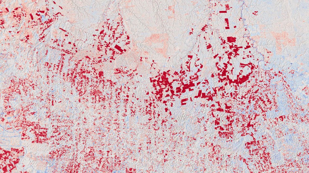
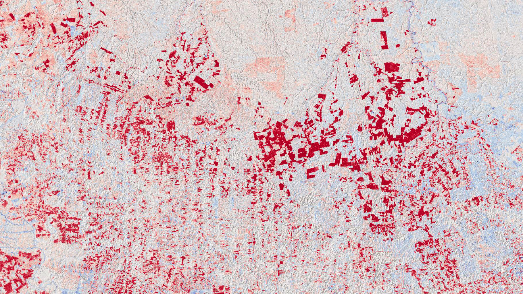
Deforestation patterns, such as those seen here in the Brazilian state of Pará, are very clearly revealed in the TanDEM-X DEM Change Maps by the height decreases marked in red.
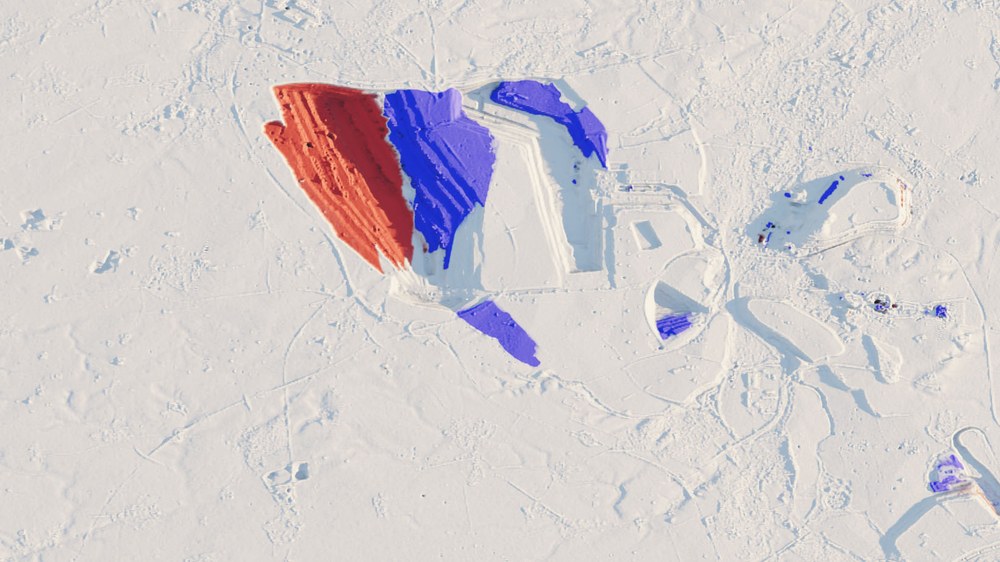
Garzweiler opencast lignite mine, North Rhine-Westphalia
From this TanDEM-X DEM Change Map (decrease/increase in height in red/blue) of the Garzweiler opencast lignite mine, the total excavation over the given period can be determined.
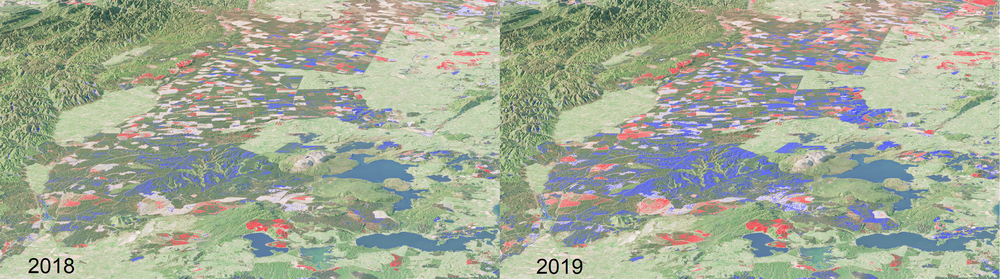
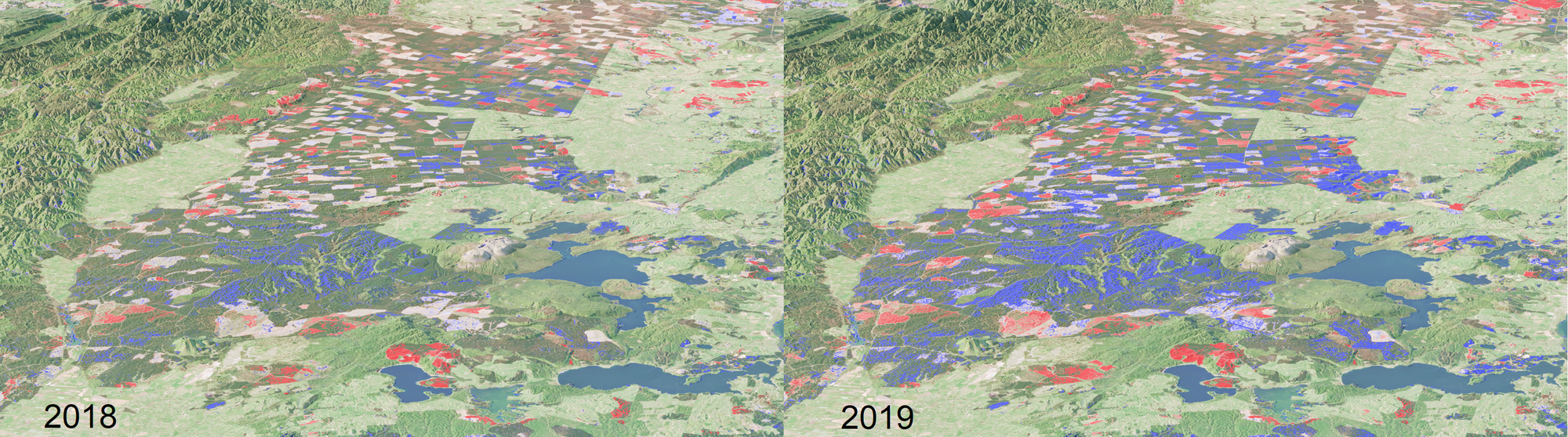
This scene east of Lake Taupo on the North Island of New Zealand shows the elevation change using global TanDEM-X data recorded in mid-2018 (left) and mid-2019 (right). In the upper left corner is a protected forest area that has changed little as the natural forest is growing slowly. To the right is a heavily managed forest area in which progressive deforestation can be seen in red but also regrowth in blue. Darker shades of blue appear when comparing 2018 to 2019, where the annual growth of these fast-growing trees becomes visible and measurable.
High-precision 'TanDEM-X 30 m DEM Change Maps' show changes in the Earth's surface.
The 3D change maps are the latest product of the TanDEM-X radar satellite mission. The global TanDEM-X elevation model from 2016 is also available in an edited version.
The DEM Change Maps enable precise temporal analyses for the first time and are constantly being expanded with time series images.
The German Aerospace Center (Deutsches Zentrum für Luft- und Raumfahrt; DLR) has established another milestone in 3D Earth mapping with the 'TanDEM-X 30-metre DEM Change Map', which provides a global overview of changes to Earth's surface. Change maps are relevant for everything from glacial retreat to agricultural development, volcanic activity and urban planning. Mapping changes in this way is significant for numerous research fields, climate change studies and socio-political issues. The new dataset from the TanDEM-X satellite mission is now freely available at a pixel spacing of 30 metres, with an absolute height accuracy down to just one metre, providing high-precision data across the globe.
The DEM Change Maps (DCMs) that have now been published follow the global TanDEM-X elevation model completed in 2016, which has already been used as a globally recognised reference in scientific and commercial applications. The 2016 elevation model is now also available in an edited version with the new publication, serving as a reference for calculating elevation changes for the new DEM Change Maps. The first global elevation model was created using a weighted average of several images in the period from 2011 to 2015, which is why a temporal assignment was initially only approximately possible. In contrast, in the DCMs, each individual height measurement is provided with the date of acquisition, so that precise analyses of the changes over time are possible. In addition, the mission team supplemented the elevation data with a global forest map and a precise 'water mask' to support the analysis of the DEM Change Maps.
"Earth's surface is subject to dynamic changes in many areas. A comparison of the new data sets shows in astonishing detail how the topography of the planet has changed within a period of six to eight years," explains Marie Lachaise from the DLR Remote Sensing Technology Institute.
Landscape changes due to opencast coal mining
For example, the changed landscapes of coal mining areas can be seen across Germany. DEM Change Maps can be used to derive the amount of lignite mined and the volume of overburden – the material laying above the mineral deposit. Using the example of the Garzweiler opencast mine in North Rhine-Westphalia, the researchers calculated that a total volume of approximately 490 million cubic metres of soil was excavated between 2011/2013 and 2018. This order of magnitude is consistent with the information provided by the energy supply company, which puts coal extraction at 30 million tonnes and an excavation capacity of 100 to 120 million cubic metres per year.
Forests in transition
One natural resource that helps to counteract global warming is forests. Drastic deforestation, particularly in tropical rainforests, is therefore under particular scrutiny. X-band radar signals penetrate to only a limited extent over forested areas, which is why the TanDEM-X heights are close to the top of the canopy. This is referred to as a surface model. In the 3D Change Map, the deforestation patterns are clearly visible via the height reduction.
The impacts of climate change
Changes in glaciers and ice fields are highly sensitive indicators of climate change. The TanDEM-X DCMs reveal how dramatically Earth's polar regions have changed over the course of just a few years. Among other phenomena, the Southern Patagonian Ice Field in Chile has seen melting on a massive scale. In particular the Jorge Montt Glacier has shrunk dramatically since the first elevation model was created. According to change analysis, the glacier lost a total volume of approximately 10.7 cubic kilometres between 2010/2014 and June 2018. This represents a melting rate of up to 2.6 cubic kilometres per year.
In contrast, the Brüggen Glacier (also known as the Pío XI Glacier), which flows from the Southern Patagonian Ice Field, has increased in volume. In total, it appears to have grown by approximately 7.6 cubic kilometres over the same period. According to the latest studies, local geological and climatic conditions have led to unusual growth over recent decades. The new 3D Change Map will help researchers understand these complex glacier processes.
The fourth dimension – time
The mission was originally planned to last five years. After more than 13 and 16 years of operation, the twin satellites continue to reliably deliver high-quality radar data and will continue to be used to record 3D changes in the cryosphere, global forests and large cities. The TanDEM-X 30-metre DEM Change Maps now available cover all topographical changes. The goal is to generate the longest possible time series of DCMs. In the future, the time axis will increasingly raise the change maps into the fourth dimension. Forest areas, for example, could then be analysed quantitatively and even their growth will be recorded.
About the mission
The TerraSAR-X and TanDEM-X missions were implemented on behalf of the German Aerospace Center (Deutsches Zentrum für Luft- und Raumfahrt; DLR), with funding from the Federal Ministry for Economic Affairs and Climate Action (Bundesministerium für Wirtschaft und Klimaschutz; BMWK). They are the first German satellites to have been created as part of a Public-Private Partnership (PPP) between DLR and Airbus Defence and Space GmbH. DLR is responsible for the construction and operation of the ground segment as well as for the scientific use of the data and its distribution to external researchers worldwide. Airbus Defence and Space GmbH contributed to the costs of the development, construction and launching of the satellites. The Geo-Intelligence programme line at Airbus Defence and Space is responsible for the commercial marketing of the data. Since 2016, the project has continued under a follow-on agreement with Airbus.
The DLR Microwaves and Radar Institute, the DLR Remote Sensing Technology Institute and the DLR German Remote Sensing Data Center are involved in the mission and together form the 'SAR Centre of Excellence'. The institutes complement each other by covering all relevant areas from sensor technology and mission design to high-precision operational processing and refined user products. Together with DLR's German Space Operations Center, they were also responsible for constructing the ground segment – that is, the infrastructure for operating the satellites and processing the data. Scientific management is the responsibility of the DLR Microwaves and Radar Institute in Oberpfaffenhofen.
