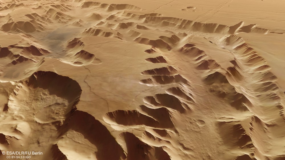
At the western end of the Valles Marineris, the Noctis Labyrinthus area – the 'Labyrinth of Night' – forms the transition to the Tharsis region with its four enormous volcanoes, some of which are more than 20 kilometres high. Extension processes in the Martian crust caused an area approximately the size of Germany to break up into a bizarre landscape of mesas up to 7000 metres tall, separated by tectonic grabens. Even the depressions visible on the highland plain in the left half of the image are not shallow valleys eroded by water, but tectonic structures. The perspective HRSC image section shown here has a width of approximately 120 kilometres at the base.
Expansion tectonics has created the Noctis Labyrinthus region – the 'Labyrinth of the Night' – between the Valles Marineris in the east and the Tharsis volcanic region to the west. The parts of the region that have sunk between the remaining elevated blocks have created grabens up to 7000 metres deep. Due to the very steep topography, intensive erosion has occurred, in some cases also involving water, which was certainly present there for some time. In the centre of the image, typical terrain forms can be seen with retrograde erosion creating side valleys, and on the left in the foreground (image width there approximately 200 kilometres) traces of large landslides.
The Noctis Labyrinthus region was already visible in the late 1970s on images acquired by NASA's two Viking orbiters. It marks the transition between the Tharsis bulge with its large volcanoes in the west and the tectonic valley system of Valles Marineris, the 'Valleys of Mariner', named after the Mariner 9 spacecraft, which first imaged the 4000-kilometre-long structure in 1971. The labyrinthine pattern of the 'Labyrinth of the Night' was also created by tectonic expansion fractures in the Martian crust. The mosaic on which the images shown here are based was calculated from eight individual image strips acquired by HRSC.
For 20 years, DLR's HRSC instrument on board the Mars Express spacecraft has been providing high-resolution images of Earth's neighbouring planet.
The first image was transmitted to Earth on 10 January 2004.
In the meantime, the camera has achieved a coverage of over 85 percent of the Martian surface.
This image mosaic of the Noctis Labyrinthus region consists of eight individual HRSC images with a resolution of 12.5 metres per pixel.
Focus: Spaceflight, Mars, planetary research, Mars Express mission
An extraordinary success story, and a long-lasting one at that. For 20 years now, DLR's High Resolution Stereo Camera (HRSC) on board the European Space Agency (ESA) Mars Express orbiter has been providing the science community and the public with fascinating high-resolution images of Earth's neighbouring planet. The first image – showing the Hydraotes Chaos region – was transmitted to Earth on 10 January 2004. Since then, HRSC has captured Mars globally in high resolution, in colour and in 3D, enabling numerous scientific discoveries. These range from evidence left by water and ice over billions of years to deciphering the climate history and more recent landscape changes caused by wind and weather. One of the latest additions is a mosaic of eight individual images of the Noctis Labyrinthus region between Valles Marineris and the volcanoes of the Tharsis highlands. A virtual flight over this area was published in October 2023.
Image mosaic of the 'labyrinth of the night'
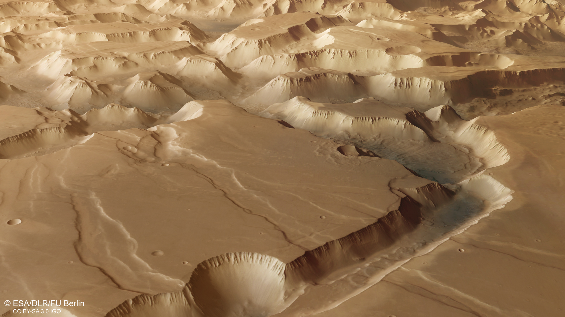
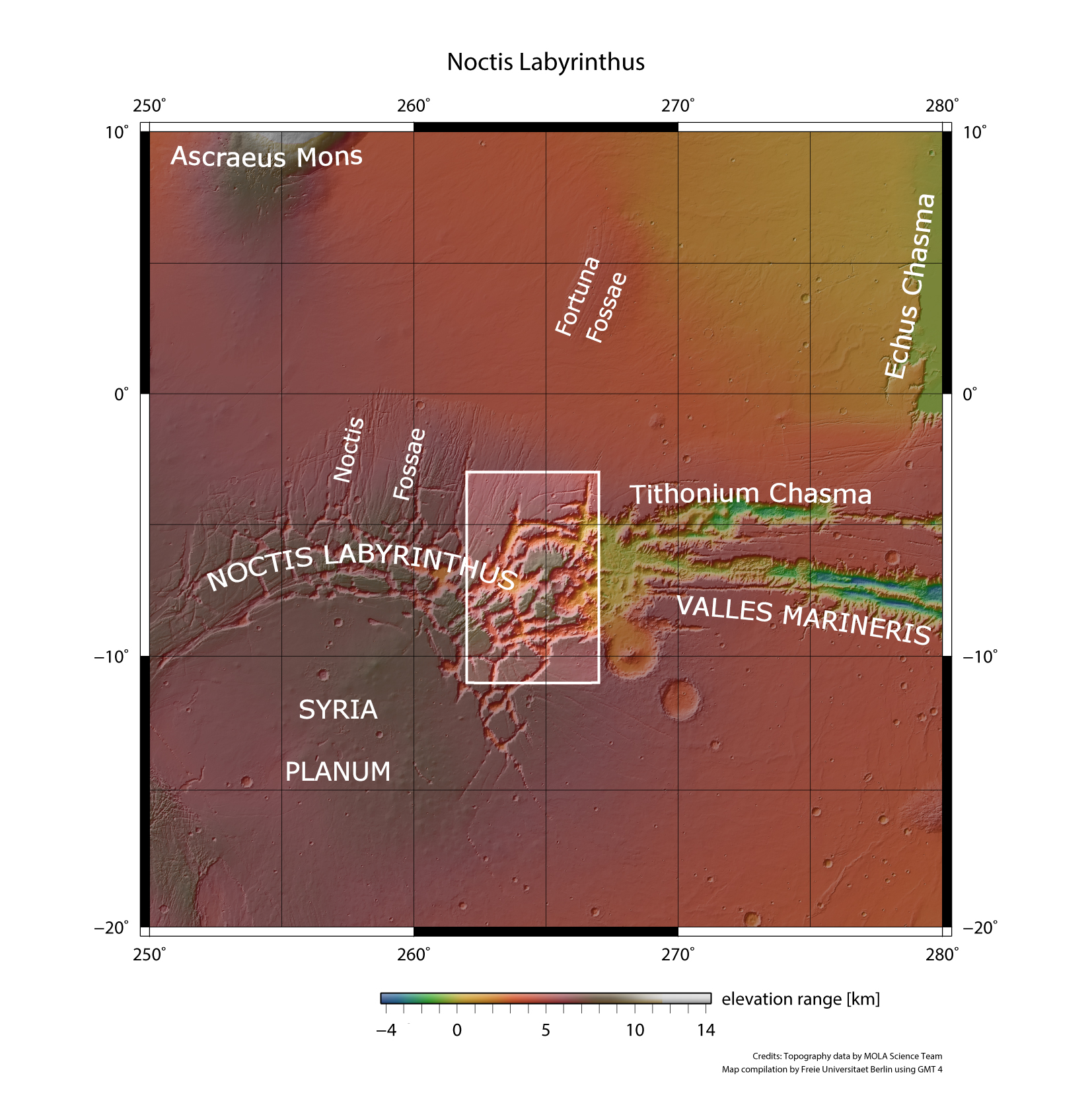
Noctis Labyrinthus – Latin for 'labyrinth of the night' – is located between the western end of Valles Marineris and the Tharsis highlands. The labyrinth is 1190 kilometres long and almost comparable in size to Germany. This area is characterised by a system of deep and steep-sided valleys that were formed by displacements in the Martian crust. Many have the classic appearance of a tectonic rift. Crustal extension has caused parts of the surface to subside between two blocks that remained stationary on either side. The images clearly show intersecting canyons and valleys up to 30 kilometres wide and as much as six kilometres deep. There is no comparable geological feature on Earth.
Intense volcanism in the west of the Tharsis region, which was associated with the uplift of large areas, formed this landscape. Tectonic stresses resulted in thinning and stretching of the crust and the formation of grabens. Large plateaus are the dominant feature of the region at the original surface level of the Martian highlands – a unique landscape in the Solar System.
The image mosaic presented here consists of eight individual HRSC images with a resolution of 12.5 metres per pixel. A GIS-capable digital terrain model is also part of this image sequence. GIS stands for 'Geographic Information System', with which digital spatial landscape data can be recorded, processed and analysed. The anaglyph image, a visually three-dimensional representation in grayscale, was not produced using the stereo channels of the HRSC as is usual. Instead, the digital terrain model and the nadir mosaic – providing a vertical plan view of the area – were utilised to create a 'virtual' anaglyph image. The labelled image reveals the locations of intriguing geological features, unveiling numerous striking details that become evident to the viewer upon closely zooming into the image.
A closer look at Noctis Labyrinthus – the 'truth' is in the details
The mosaic presented here shows the diverse details and their geological context in the eastern part of the Noctis Labyrinthus region. The labelled image shows the locations of interesting geological features. The mosaic is very large and contains many details that can only be seen if one zooms deep into the image. In many places, large landslides can be seen covering the steep valley slopes and the valley floors.
Spectral analyses have revealed layers of hydrated sulphates and clay minerals on the steep slopes. These minerals indicate an aqueous environment in the past. It is very likely that these rocks were weathered when water was present in Noctis Labyrinthus. Narrow, linear channels also indicate the former presence of water in the area. The chaotically fractured areas may have been created by the melting of ground ice and the subsequent collapse of the overlying surface.
Elsewhere, long, widely branching linear structures can be observed on the valley slopes. These are sand and dust deposits that have been shaped by the wind into extensive ribbed fields whose ridges are separated by distances of between 150 and 400 metres. These sand ridges are orientated perpendicular to the wind direction and are often formed on large bodies of sand or dune surfaces. The almost vertical orientation of the ridges on numerous slopes indicates that sand was transported there parallel to the slope, while on the valley floors or on shallower slopes, the wind transported the fine-grained material from different directions along the valleys and also uphill.
'Marathon' around Mars
Mars Express is ESA's first planetary mission. It was initially planned to last just one Martian year, equivalent to two Earth years. Due to its scientific success and the longevity of the instruments, the mission has been extended seven times and is now expected to continue until 2026. In total, the spacecraft has travelled around 1.2 billion kilometres around Mars – and an additional 500 million kilometres from Earth to Mars. At the end of January 2024, Mars Express will orbit the Red Planet for the 25,330th time.
Launched from Baikonur, Kazakhstan, on 2 June 2003, Mars Express successfully arrived at its destination on Christmas Day of that year. The spacecraft entered orbit around Earth's outer neighbour; however, issues arose with the previously separated British lander, Beagle 2. Although Beagle 2 landed on the surface of Mars, it failed to transmit any data from there. All seven experiments on Mars Express, including HRSC, operated flawlessly. They continue to function to this day with only minor limitations.
The High Resolution Stereo Camera (HRSC), jointly developed by DLR and German industry, introduced a pioneering camera concept unprecedented in planetary mapping. Utilising a single lens, referred to as an Apo-Tessar telescope, nine line sensors are arranged transversely to the direction of flight to capture a continuous image strip of the Martian surface as the orbiter moves. Functioning in a similar way to a scanner, it systematically scans the image line by line. Each sensor captures the same object on the surface from a distinct angle. Four channels face forwards, four face backwards, and a ninth channel – the nadir channel – is centrally positioned, capturing a vertical perspective directly downwards.
On the ground, 3D models of the surface are then computed using the data acquired by the four stereo image strips and the nadir channel, which provides the highest image resolution at 10 to 12 metres per pixel. The remaining four of the nine line sensors are equipped with special colour filters for recording multispectral data. The heart of the camera, the focal plane with the nine sensors, was developed by DLR.
The images produce a constantly growing collection of spectacular views of the varied Martian landscape, image and terrain model mosaics as well as animations that can be derived from the digital terrain models. The camera has now achieved over 85 percent coverage of the Martian surface with a high resolution (better than 20 metres per pixel). Hundreds of planetary scientists around the world are working with this data.
Image processing
The Noctis Labyrinthus mosaic consists of eight HRSC images. The ground resolution is approximately 12.5 metres per pixel, and the image is centred at about 265 degrees east and seven degrees south. The colour image was created using data acquired by the nadir channel and the colour channels. The oblique perspective views were created using a Digital Terrain Model (DTM) and data acquired by the nadir channel and the colour channels. The anaglyph image, which gives a three-dimensional impression of the landscape when viewed with red/blue or red/green glasses, was derived using information from the DTM of the mosaic. The colour-coded topographic view is based on a DTM of the region, from which the topography of the landscape can be derived. The reference body for the HRSC-DTM is a Martian equipotential surface (areoid).
This time, in addition to the images described above, the HRSC team at Freie Universität Berlin has made the original data set of the digital terrain model and the associated image information available for download as georeferenced mosaics. They can be opened and analysed in all common geoinformation systems (for example in the open source software QGIS). Additional information can also be found on the document server website. Please always quote the DOI 10.17169/refubium-41764 when using this data.
The High Resolution Stereo Camera (HRSC) was developed at the German Aerospace Center (DLR) and built in cooperation with industrial partners (EADS Astrium, Lewicki Microelectronic GmbH and Jena-Optronik GmbH). The science team, led by Principal Investigator (PI) Daniela Tirsch from the DLR Institute of Planetary Research, consists of 50 co-investigators from 35 institutions and 10 nations. The camera is operated by the DLR Institute of Planetary Research in Berlin-Adlershof.


