15 years of TanDEM-X – DLR's pioneering Earth observation mission celebrates its anniversary
December 16, 2025
15 years of TanDEM-X – DLR's pioneering Earth observation mission celebrates its anniversary
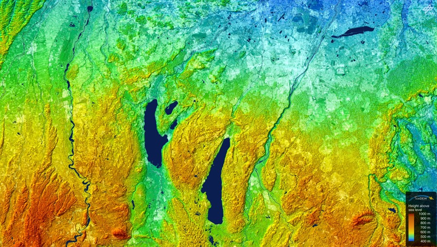
Visualisation of the TanDEM-X digital elevation model over southern Bavaria
This region is known for its lakes. In addition to the city of Munich (top right), the image shows Lake Starnberg (centre), Lake Ammer (left of centre), the Peißenberg mountain (bottom left) and the rivers Lech (left), Isar (centre) and Mangfall (right).
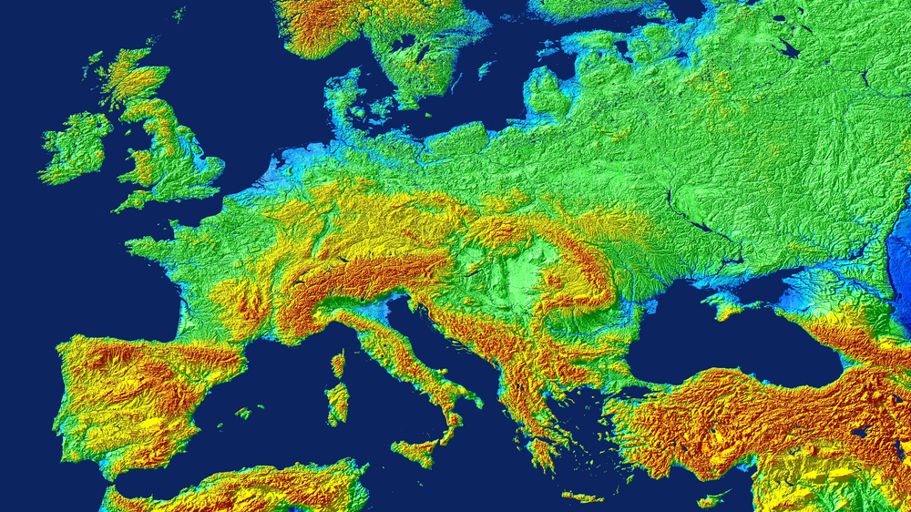
Visualisation of the TanDEM-X digital elevation model over central and southern Europe
Clearly recognisable here are the Alps (centre), the Po Valley in northern Italy and the Great Hungarian Plain, which is bordered by the Carpathian Mountains.
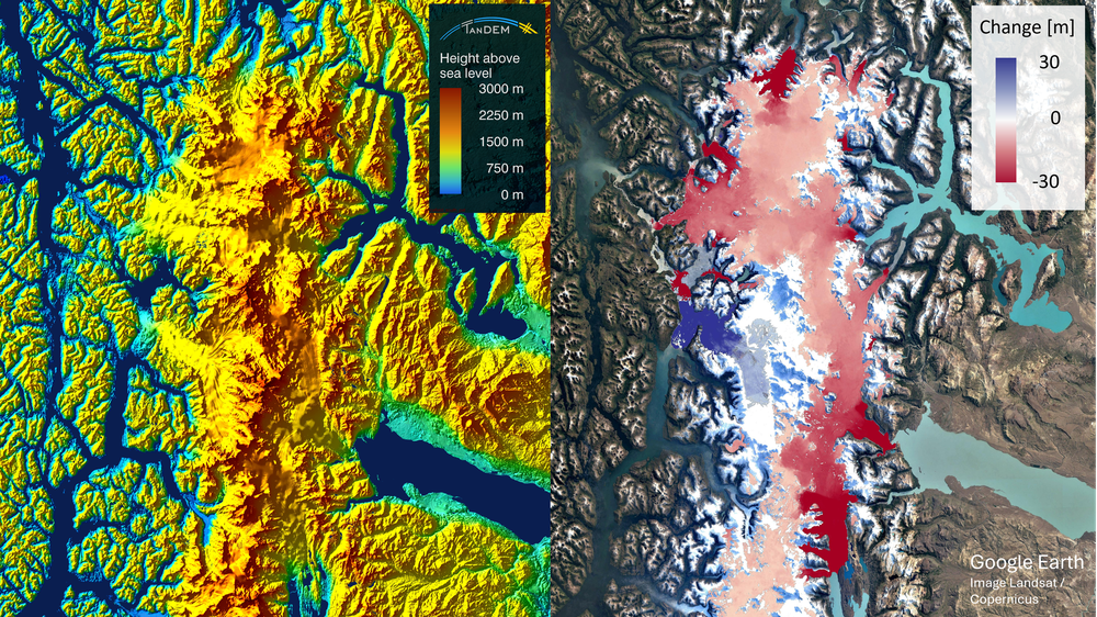
TanDEM-X elevation model and change map of the South Patagonian Ice Field on the border between Chile and Argentina
The red colouring indicates an elevation loss of up to 30 metres across large parts of the glacier region. Only the smaller blue area represents an increase in snow volume across a very limited area of the glacier.
Exactly fifteen years ago, the German TanDEM-X mission began its operational data acquisition to generate a global elevation model of the Earth.
Today, this digital elevation model (DEM) is a global topographic standard.
To ensure continuity in Earth observation, DLR is developing concepts for next-generation radar satellites with even higher DEM accuracy.
Focus: Space, Earth observation, radar
Exactly 15 years ago – in December 2010 – the German TanDEM-X mission began operational imaging to generate a global elevation model of Earth, marking the start of a success story that continues to this day. Over the following six years, the German Aerospace Center (Deutsches Zentrum für Luft- und Raumfahrt; DLR) used the data generated from the two satellites to create a high-precision, consistent digital elevation model (DEM), covering the entire land surface of Earth. This unique product has since become a global topographic standard.
On the occasion of the anniversary, DLR Chair of the Executive Board Anke Kaysser-Pyzalla commented on the mission’s results:
TanDEM-X demonstrates the critical importance of continuous and comprehensive Earth observation for both the public sector and the economy. The mission also showcases Germany’s expertise in the use of satellite-based radar technology as well as data processing and analysis. Space-based data is indispensable for informed decision-making – from disaster management and infrastructure planning to questions of sustainable development. With its first-class and consistent datasets, TanDEM-X helps to effectively support industry, public administrations and other public stakeholders such as local authorities. In light of the current geopolitical situation, it is vital to further expand these capabilities.
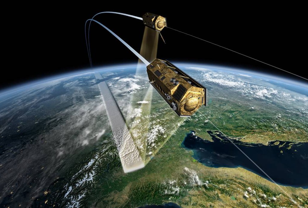
The TanDEM-X mission comprises the twin satellites TerraSAR-X, launched 15 June 2007, and TanDEM-X, launched 21 June 2010. Following its launch, the TanDEM-X satellite was calibrated at a safe distance of approximately 20 kilometres behind TerraSAR-X. In October 2010, engineers guided the two satellites into their current close formation flight, separated by just a few hundred metres – the most challenging phase of the mission.
Over the following weeks, the satellites' interferometric capabilities – the interaction between the two satellites – were tested and fine-tuned. For interferometry, one of the satellites transmits a signal to Earth's surface, and both satellites receive the reflected echo.
At DLR’s site in Oberpfaffenhofen, three-dimensional elevation data is calculated from the measurements and mosaicked into a global product with an absolute vertical accuracy of one metre on a global grid of twelve by twelve metres. The first global elevation model was released in 2016, and remains freely accessible as the European Space Agency's (ESA) Copernicus DEM.
Speaking at the anniversary event organised by the DLR Microwaves and Radar Institute on 11 December 2025, Anke Pagels-Kerp, the DLR Divisional Board Member for Space, said: "With TanDEM-X, we have achieved – together with partners from the private sector – a technological milestone in radar remote sensing. The mission's 3D radar data is being used across research, commercial applications and the security sector. This versatility underlines the major societal benefits of this mission."
Beyond the digital elevation model
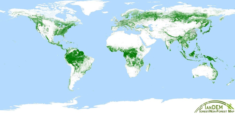
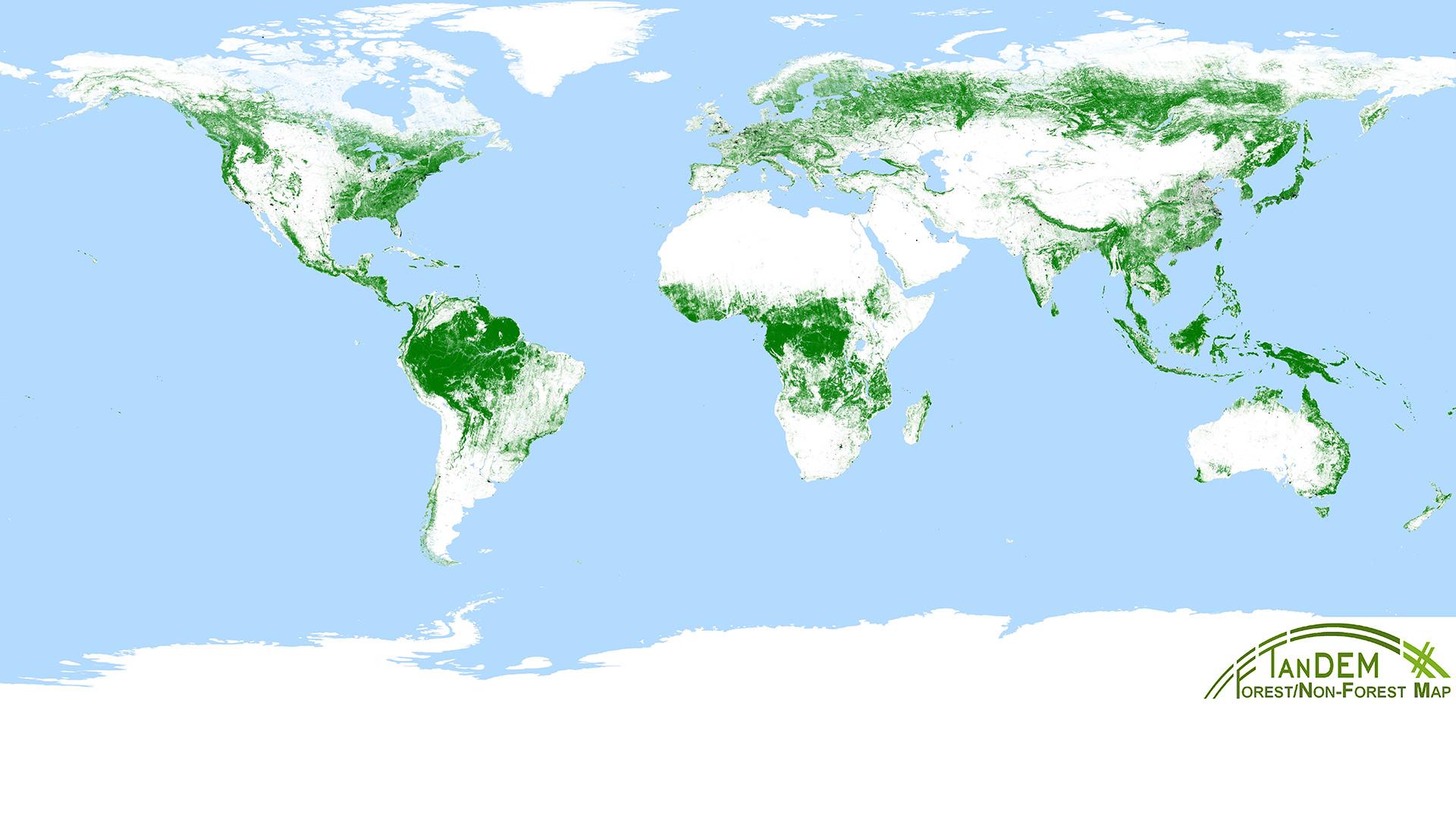
Global TanDEM-X forest map
A special dataset developed by DLR: interferometric data acquired for the global TanDEM-X elevation model were used, and AI algorithms were developed for data processing.
TanDEM-X was originally designed for a duration of five years. However, fuel supplies and the good condition of the satellites have enabled their reliable operation to this day. This has meant further global coverages could be acquired to document and make use of temporal changes in the topography of Earth's surface. The resulting ‘DEM Change Maps’ are freely available via the DLR Geoservice. From early 2026, an independent DEM based on data acquired from 2017 to 2020 will also be available via the TanDEM-X Science System.
Commercially, the data is marketed by Airbus Defence and Space and also used by ministries such as the German Federal Ministry of Defence (BMVg). Over 6500 researchers have used this data to carry out a wide range of scientific projects, gaining valuable new insights.
Examples of scientific projects using TanDEM-X data:
Measurement of global glacier ice loss
Measurement of shifts in the grounding line of outlet glaciers in Antarctica
Highly accurate measurement of crop growth, such as wheat, rice and maize
Creation of a global forest/non-forest map
Monitoring of commercially managed forests
Derivation of a highly accurate global surface water runoff map
Creation of a global urban footprint
Looking ahead: MirrorSAR
To ensure German continuity in Earth observation, DLR is devising new concepts for next-generation radar satellites that will build on the success of TanDEM-X. The main goal is to improve the accuracy of digital elevation models.
Alberto Moreira, Director of the DLR Microwaves and Radar Institute, emphasises: "TanDEM-X has far exceeded all expectations, setting the bar correspondingly high for a successor mission. With the multistatic radar system MirrorSAR, which has proven to be particularly well suited, we aim to create a terrain model with an accuracy an order of magnitude higher than that of TanDEM-X. There is an equally great need for a new, more precise 3D image of Earth to keep pace with the rapidly improving quality of navigation and remote sensing data. While the resolution of remote sensing imagery is now at the metre scale, the most accurate global 3D dataset – the TanDEM-X digital elevation model – still has a grid resolution of twelve metres."
The MirrorSAR system comprises a main satellite that illuminates the scene and three or more accompanying satellites that act solely as receivers and 'mirror back' the data to the main satellite. The requirements for the receiver satellites can therefore be drastically reduced. New Space platforms – small satellites that can be produced at considerably lower manufacturing costs – are therefore suitable for cost-efficient implementation.
The TerraSAR-X and TanDEM-X missions were implemented by DLR with funding from the Federal Ministry of Economic Affairs and Climate Action. These missions are the first German satellites to be realised under a ‘Public-Private Partnership’ (PPP) between DLR and Airbus Defence and Space. DLR is responsible for the development and operation of the ground segment, as well as for the scientific use of the data and its distribution to external researchers worldwide. The total costs of the space segment were financed by Airbus Defence and Space and the German Space Agency at DLR. The ‘Geo-Intelligence’ programme line at Airbus Defence and Space is responsible for the commercial marketing of the data. Since 2016, the project has been continued under a continuation agreement with Airbus.
Also involved in the mission are four DLR institutions: the Microwaves and Radar Institute, the Remote Sensing Technology Institute, the German Remote Sensing Data Center, and the German Space Operations Center. These are responsible for the establishing and operating the ground segment – that is, the infrastructure for controlling the satellites, and for reception, processing and distribution of the acquired data and products. The DLR Microwaves and Radar Institute, located in Oberpfaffenhofen near Munich, is responsible for the scientific management of the mission.


