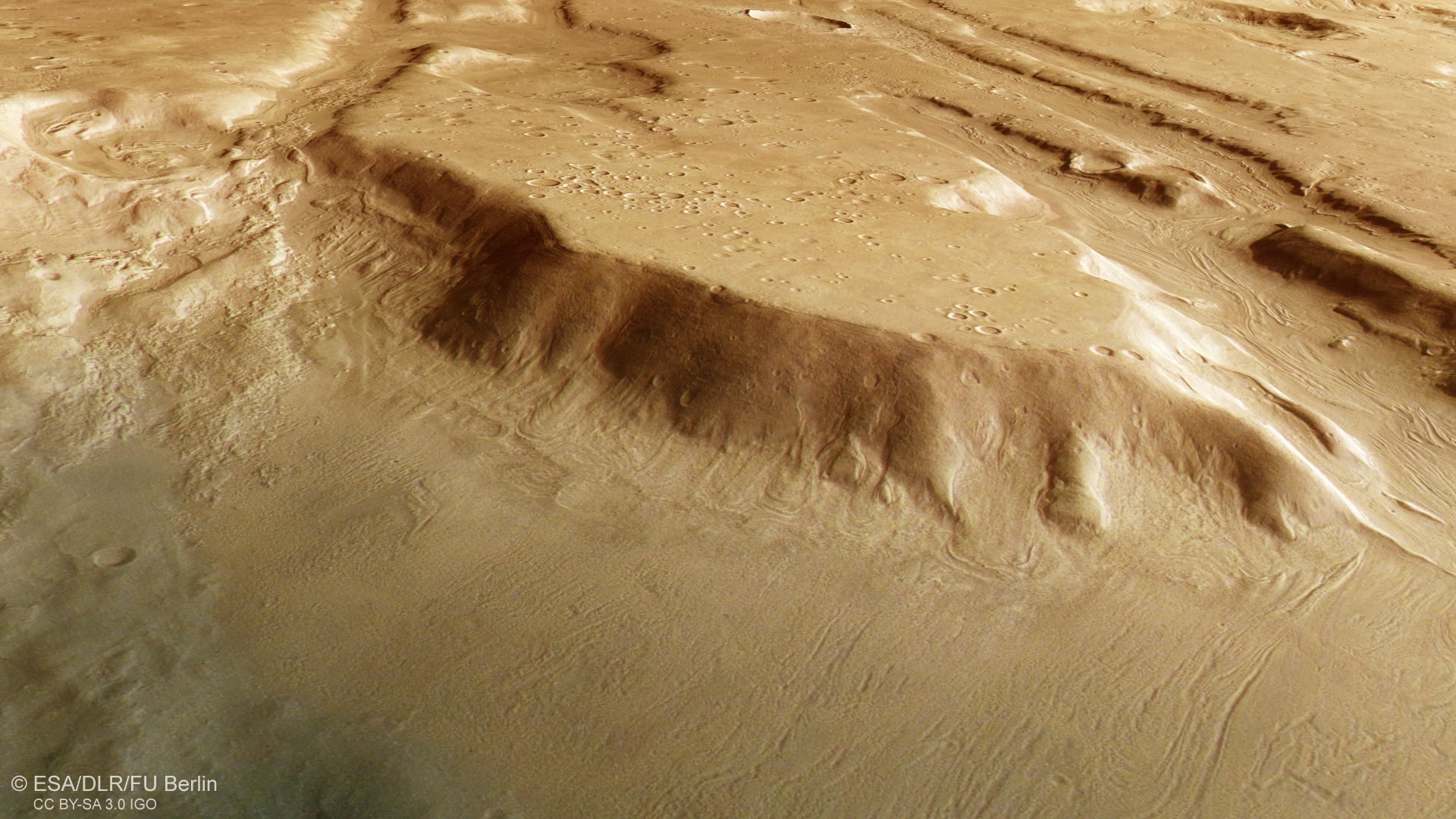
Mighty table mountains over 2000 metres high mark the transition from the southern highlands to the northern lowlands in the Coloe Fossae region. Traces of landslides along the steep slopes indicate that the broken-off rock masses were at least partially embedded in glacial ice. The approximately 30-kilometre-long table mountain ridge features numerous ‘secondary craters’ originating from the ejecta of a larger impact. Tectonic grabens, or troughs, can be seen in the background.
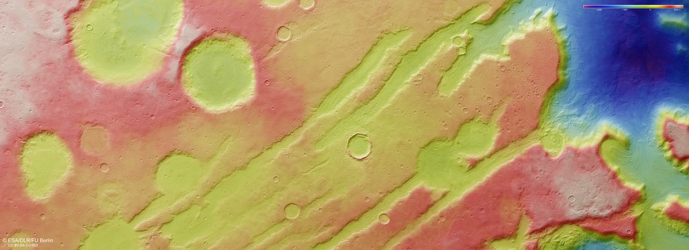
DLR’s HRSC stereo camera on board Mars Express captures the Martian surface from multiple viewing angles using its nine sensors. From this data, the DLR Institute of Space Research and Freie Universität Berlin generate digital terrain models. The colour scale at the top right of the image indicates the elevation values. In the northern part of the Coloe Fossae region, which is crossed by tectonic rift valleys (‘fossae’), the Martian highlands drop abruptly more than 3000 metres into the northern lowlands of Utopia Planitia.
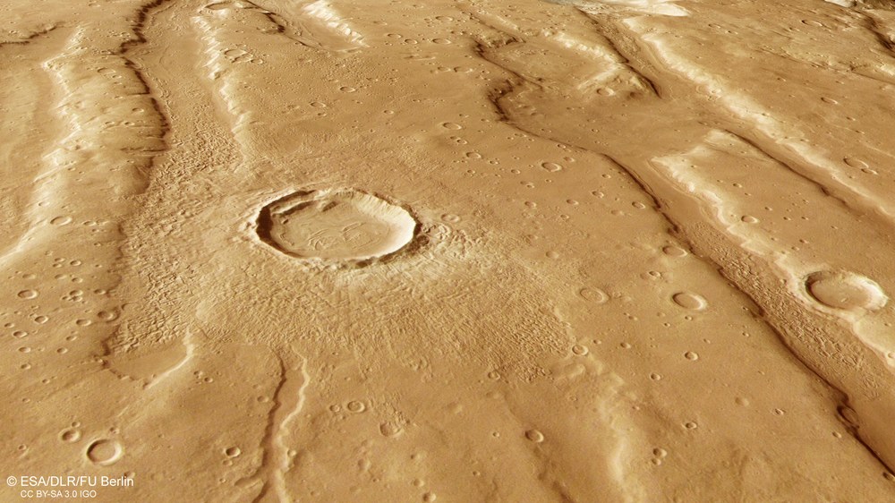
Impact crater with ejecta blanket and evidence of ice
This image shows a relatively young impact crater measuring approximately 12 kilometres across on the Coloe Fossae plateau. The impact occurred after the crust had stretched, as some of the ejected material settled in the linear grabens running on both sides of the crater. Streak-like features inside the crater indicate that mixtures of rock and ice slid down from the crater walls and were pushed together on the floor.
New images from DLR's HRSC stereo camera reveal a Mars region shaped by marsquakes, impacts and climatic extremes.
The Coloe Fossae troughs form part of the 'planetary dichotomy' dividing the highlands of Terra Sabaea from the lowlands of Utopia Planitia.
The basin floors offer valuable insights into Mars' history, particularly its climatic evolution.
Focus: Space, exploration, Mars Express, HRSC stereo camera
Anyone reading 'Coloe Fossae' and thinking of a carnivorous species from Madagascar is clearly on the wrong track – they are, in fact, extensive troughs on Mars. Recently processed images based on data collected by DLR's High Resolution Stereo Camera (HRSC) show a region shaped by marsquakes, impacts and climatic extremes. HRSC is a camera experiment developed by DLR on board the ESA Mars Express mission, which has been in operation since January 2004.
The Coloe Fossae lie in Mars' northern hemisphere and are part of the 'planetary dichotomy’ that separates the highland region of Terra Sabaea from the lowland plains of Utopia Planitia (see annotated image). This boundary is marked by a steep 'escarpment', or slope, with a height difference of more than two kilometres. The cause of this division of our neighbouring planet is still unclear. One possibility is that more than four billion years ago, the northern hemisphere of Mars was struck by a minor planet in a grazing impact, tearing away several kilometres of rock crust in the north.
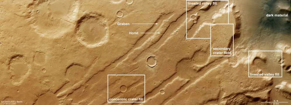
Landscape features in the Coloe Fossae region
Along fault lines in Coloe Fossae, crustal blocks have sunk several hundred metres. The troughs were later filled with ice, which began to flow under its own weight and followed the contours of the terrain. As the ice melted and sublimated (evaporated), debris carried along on these 'block glaciers' was deposited as concentric crater fill or lineated valley fill. A cluster of small, ‘secondary craters’ on a highland ridge is the result of ejecta from a larger impact – a secondary crater field. Wind carried dark volcanic ash dust into the lowlands to the north 'dark material'.
From north (right in the overhead views) to the south (left in the images), the Coloe Fossae are crossed by crustal blocks forming what geologists refer to as 'horst and graben' structures. There are numerous such structures on Mars, where the rock crust has been stretched and domed due to rising magma chambers, such as in the north of the giant volcano Olympus Mons. The surrounding terrain features several impact craters, including clusters of small, irregularly shaped craters. These 'secondary craters' occur when material is ejected during an asteroid impact and falls back onto the surface, creating further craters. In this case, the crater-forming projectile comes from the impacted object itself.
Impact craters as an indicator of the age of the surface
Impacts from asteroids and meteorites – bodies ranging from hundreds of kilometres across to micrometre-sized dust grains left over from the formation of the planets – are the most significant external process shaping the surfaces of solid celestial bodies. On bodies with an atmosphere, dust particle-sized micrometeorites are ‘filtered out’ as they burn up in the gas envelope.
On the Moon, however – a body without an atmosphere – they strike unabated at speeds of well over 100,000 kilometres per hour, grinding its rocks into a fine powdery dust, known as regolith. On Mars, with its thin atmosphere, fewer meteorites reach the ground than on the Moon, but still significantly more than on Earth. The resulting impact craters are an important measuring stick for determining relative surface ages.
Old surfaces have many large craters that have been exposed to 'bombardment' from space over a very long period of time, while fewer and smaller craters usually indicate a younger surface. Crater sizes have also decreased over time, as the largest impactors were used up earlier in the Solar System's history, leaving only smaller ones in more recent epochs. The sparse impact craters on the trough floors therefore indicate that these deposits are significantly younger than the heavily cratered surrounding terrain.
Linear valley fill and concentric crater fill
On closer inspection, materials on the basin floors reveal fascinating surface features that provide valuable insights into Mars' history – particularly its climatic evolution. In many places, streamlined surface patterns can be seen that are characteristic of 'linear valley fill'.
Linear valley fills form through viscous, ice-rich deposits similar to terrestrial block glaciers covered by a layer of debris or rock. These deposits likely consist of more than 80 percent ice, buried under a thick layer of rock material that shields them from sublimation – the direct transition of ice into vapour. The linear surface textures result from the slow flow of ice masses along the valley slopes. In the middle of the valley, these ice flows converge and are pushed together – similar to the effect when a tablecloth is pushed in from both sides.
Comparable features within impact craters are known as 'concentric crater fill', examples of which can be seen in some craters in the image. Both surface structures are a clear indication of former glacial activity within the trenches and depressions. But how could such glaciation have occurred so far from the Martian poles?
The fact that there were glaciers in the mid-latitudes of Mars is an indication that the now dry planet experienced alternating cold and warm periods throughout its evolution. Repeated freeze–thaw cycles drove this process. Such climate fluctuations are caused by changes in Mars' orbital parameters – its varying distance from the Sun on its elliptical orbit, and especially the tilt of its rotational axis, which is subject to strong fluctuations.
Greater axial tilt – more ice at mid-latitudes
Unlike Earth's axis, which has remained largely stable at about 23.5 degrees for over four billion years thanks to the Moon’s stabilising influence, Mars’ axial tilt fluctuates much more strongly and frequently due to gravitational influences from other planets. The resulting cycles of 'obliquity', or axial tilt, cause regular climate changes on Mars – and shift the distribution of surface ice.
Put simply, during periods of high axial tilt, ice spreads from the poles towards the mid-latitudes. When the tilt decreases – as is the case today – the ice retreats back to the poles, leaving visible traces in the landscape. The repeated occurrence of such features along the dichotomy boundary at similar latitudes suggests that global climatic processes are responsible rather than local environmental changes.
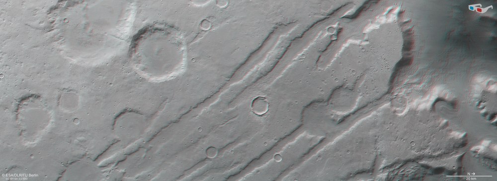
3D anaglyph image of the Coloe Fossae region
By combining data from HRSC’s nadir channel, which looks straight down, and one of its oblique stereo channels, anaglyph images can be produced that allow a three-dimensional view of the landscape. These are particularly useful for studying tectonic fault troughs but also reveal subtle details such as streaky flow structures formed by debris-laden glaciers.
The images were acquired by the High Resolution Stereo Camera (HRSC) during Mars Express orbit 26,257. The ground resolution is approximately 16 metres per pixel, and the images are centred at approximately 39 degrees north and 54 degrees east. The colour image combines data from the nadir channel, which is aligned perpendicular to the Martian surface, with the HRSC colour channels. The oblique perspective view uses the digital terrain model (DTM), nadir channel and the HRSC colour channels. The anaglyph image, which produces a three-dimensional impression of the landscape when viewed with red/blue or red/green glasses, combines the nadir channel and one stereo channel. The colour-coded topographic view is based on a digital terrain model of the region, from which the topography of the landscape can be derived.
The High Resolution Stereo Camera (HRSC) was developed at the German Aerospace Center (DLR) and built in cooperation with industrial partners (Airbus, Lewicki Microelectronic GmbH and Jena-Optronik GmbH). The science team, led by Principal Investigator (PI) Daniela Tirsch from the DLR Institute of Space Research (previously: Planetary Research), consists of 50 co-investigators from 35 institutions and 11 nations. The camera is operated by the DLR Institute of Space Research in Berlin-Adlershof.

