The 'Wild West' of Mars' Acheron Fossae graben system
August 6, 2025 | Mars Express mission
The 'Wild West' of Mars' Acheron Fossae graben system
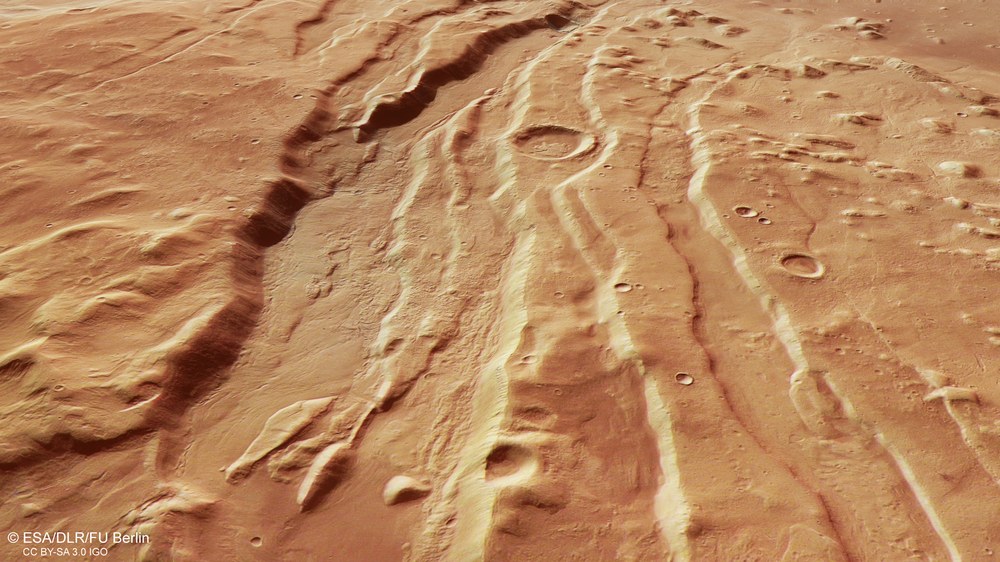
Extensional fractures in the western Acheron Fossae
North of the giant Olympus Mons volcano lies an area almost the size of Germany, shaped heavily by tectonic forces and subsequently the deposition of rubble and debris by glaciers: Acheron Fossae – a sequence of almost linear extension faults known in geoscience as a 'horst and graben' structure.
Tectonics and traces of rock glaciers in western Acheron Fossae
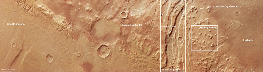
In the transition from the Martian highlands in the west of the tectonically shaped Acheron Fossae region to the northern lowlands (north is to the right in this image), a high plateau with a very flat surface is visible on the left. It is likely that rock masses slid along a fault line to the south of the Olympus Mons volcano with enough energy to travel this far north. The western edge of the tectonic faults of Acheron Fossae extends diagonally through the centre of the image. The plain on the far right is the Amazonis Planitia.
The western Acheron Fossae region north of Olympus Mons
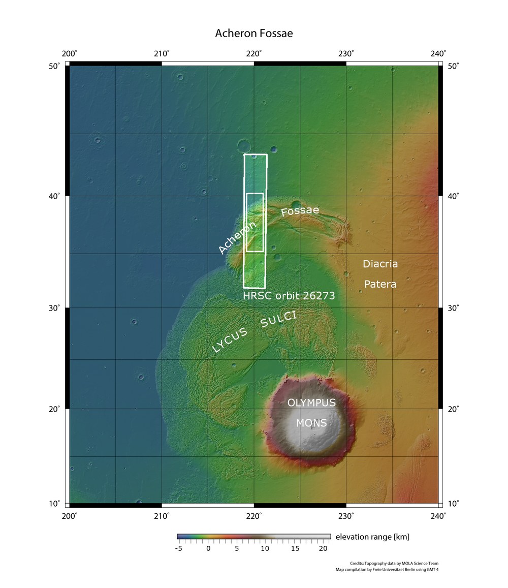
At 600 kilometres wide and 24 kilometres tall, Olympus Mons is the largest volcano in the Solar System. To the north lies the crescent-shaped aureole of the Acheron Fossae, an area marked by prominent tectonic extension faults. The landscapes to the northwest of Olympus Mons fall within the rectangular section of the HRSC image taken from orbit 26,273 of ESA's Mars Express spacecraft.
Image: 5/5, Credit:
NASA JPL (MOLA)/FU Berlin
New images from the DLR High Resolution Stereo Camera (HRSC) on board the Mars Express mission show the western part of the Acheron Fossae graben system.
Rising magma bubbles have led to tensile fractures on the Martian surface.
Block glaciers transported rock rubble and debris into these grabens.
This material likely originated from landslides on the northern flank of the huge volcano Olympus Mons.
Focus: Mars, Mars Express mission, space
Recent images from the High Resolution Stereo Camera (HRSC) show the western part of the vast Acheron Fossae graben (trough) system on Mars. Developed by the German Aerospace Center (Deutsches Zentrum für Luft- und Raumfahrt; DLR), the HRSC is carried aboard ESA's Mars Express mission. The region in the camera's field of view is located some 1200 kilometres north of Olympus Mons – the tallest volcano in our Solar System. The entire crescent-shaped mountain ridge stretches over an approximate length of 800 kilometres, merging into the plains of Arcadia and Amazonis on its northern and western sides. To the south, the rift system meets the landslide mass at the foot of Olympus Mons' flanks.
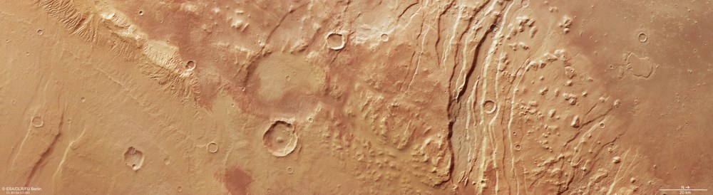
Landscape features in the western Acheron Fossae region
The consequences of various geological processes can be studied in the western part of the Acheron Fossae region – an area strongly influenced by volcanism and the associated tectonic processes. Between 3.7 and 3.9 billion years ago, the megavolcano Olympus Mons began to grow (left, outside the image). The stretching of the Martian crust created 'horst and graben' rift valleys. Later, these grabens were filled with debris and rubble transported by rock glaciers (known as lineated valley fill; LVF). The original landscape has since been almost entirely eroded. Only a few rounded hills (knobby terrain) remain. Around this terrain, small, narrow, winding gullies (meandering channels) mark the surface, which then merges into the northern lowlands. In the south, an extensive smooth surface can be seen – likely deposits of material that broke off Olympus Mons at a height of several kilometres.
Acheron Fossae is characterised by large, deep ruptures (faults) in the Martian surface. These linear fractures are a classic example of what geologists call a 'horst and graben' landscape – a pattern of raised and sunken blocks of crust that run parallel to each other. Such tectonic structures emanate from a planet's inner geological activity, where hot, malleable rock or even molten magma from the planetary mantle – the thick layer of rock between the crust and metallic core – rises to the surface. This process is also known as mantle convection.
Pressure from below stretches the surface, which then cracks along fault lines causing blocks of crust to sink downward (grabens) while neighbouring raised blocks (horsts) stay put. The Acheron Fossae likely formed approximately 3.7 to 3.9 billion years ago – in the Noachian period, when Mars was at its most geologically active. Over time, many of the troughs have been filled with various types of material, most likely deposits carried by glaciers with their ice.
What lies beneath the cracks?
In the HRSC images, several deep troughs of varying depths traverse the right, northern side of the scene (see annotated image). Closer inspection reveals smooth material with a streamlined pattern on the floors of these troughs. Known as lineated valley fill (LVF), such features are generally formed by the slow flow of debris embedded in glacial ice. The deposits are thought to be largely made up of ice covered by a layer of rubble and debris, similar to block glaciers on Earth.
Traces of geological processes in Acheron Fossae
Partially molten rock masses – or magma bubbles – rising from the rocky mantle of Mars, exerted so much pressure on the surface of the Tharsis region from below that the rigid rocky crust was stretched and torn open. This created the Acheron Fossae region – a system of crustal blocks that sank into the space created by this stretching. Glaciers laden with rubble and debris later advanced into these rifts.
Deposits like these can often be found in periglacial landscapes, which remain frozen almost year-round. This is the case on Mars as well as on Earth. Their presence suggests that the region alternately underwent cold and warm periods, driven by recurring freeze-thaw cycles. Such climate fluctuations are caused by changes in Mars' orbital parameters, in particular the varying tilt of its rotational axis. Unlike the tilt of Earth's rotational axis, which is relatively constant at approximately 23.5 degrees – and has remained stable for billions of years thanks to our Moon – the axial tilt of Mars fluctuates in a more pronounced and frequent manner due to the gravitational influences of other planets.
These variations occur with a period of just five million years, making them both frequent and relatively rapid. As a result, the amount of solar radiation received at different latitudes on Mars varies, causing shifts in the Martian climate and redistributing ice across the surface. During periods of high tilt, ice spreads from the poles towards the mid-latitudes. When the tilt is less – as it is now – ice retreats back towards the poles, but leaves behind traces that are still visible in the landscape.
Knobs, mesas and an aureole
Between the grabens and the bordering lowlands, scattered remnants of a once-continuous rock layer now shape the landscape. These residues are not heavily weathered and take varying forms – some appear as rounded hills (technically: knobs), while others have flat tops and resemble small table mountains (mesas).
Topographic image map of western Acheron Fossae
DLR's HRSC stereo camera onboard Mars Express uses its nine sensors to image the Martian surface at various angles across the flight path. The colour scale in the upper right shows elevation values relative to the areoid – an imaginary Martian reference surface (from the Latin 'Ares') with uniform gravitational pull. It clearly shows the dramatic transition from the Martian highlands to the lowlands of Amazonis Planitia (north is to the right in the image). Similar to the Alps, the elevation difference between the highest mountain peaks and the foothills exceeds 3000 metres.
Interestingly, many of them are partially surrounded by deposits which on the surface demonstrate a linear, streamlined pattern revealing the direction of movement of these sediments over the course of their deposition. This makes it possible to reconstruct how this material has been pushed some distance downhill, from the aureole around Olympus Mons into the lowlands.
The hills are most clearly visible on the right-hand side of the image and become increasingly sparse towards the centre and left. Around the knobby terrain, small, narrow winding grooves mark the surface (see annotated image). Such sinuous patterns, known as meanders, form in grooves and channels as a result of material being transported and deposited by flowing water on opposing valley slopes, just like we see along river bends on Earth.
The landscape on the left, southern side of the scene is much smoother, hinting at a different geological origin. One possibility is that these plains derive from massive landslides triggered by the collapse of Olympus Mons' northern flank, leading to the formation of a huge 'wreath' or aureole feature. In this case, the debris will also have travelled a tremendous distance to reach the foot of the Acheron Fossae.
Image processing
These images were taken by the HRSC (High Resolution Stereo Camera) on 24 October 2024 during Mars Express Orbit 26,273. The ground resolution is approximately 16 metres per pixel, with the vertical nadir images centred at about 220° East and 37° North. The colour image was created with data from the nadir channel – with the field of view oriented perpendicular to the Martian surface – and the HRSC colour channels. The oblique perspective view was created from the digital terrain model (DTM), the nadir channel and the colour channels of the HRSC. The anaglyph image, which conveys a three-dimensional impression of the landscape when viewed with red-blue or red-green glasses, was created from the nadir channel and one stereo channel. The colour-coded view is based on a digital terrain model of the region, from which the topography of the landscape can be derived.
The High Resolution Stereo Camera was developed at the German Aerospace Center (DLR) and built in cooperation with industrial partners (EADS Astrium, Lewicki Microelectronic GmbH and Jena-Optronik GmbH). The science team, led by Principal Investigator (PI) Daniela Tirsch, consists of 50 co-investigators from 35 institutions across 11 nations. The camera is operated by the DLR Institute of Space Research (formerly DLR Institute of Planetary Research) in Berlin-Adlershof.
