New images of the Acheron Fossae graben system on Mars
April 9, 2025 | Mars Express mission
New images of the Acheron Fossae graben system on Mars
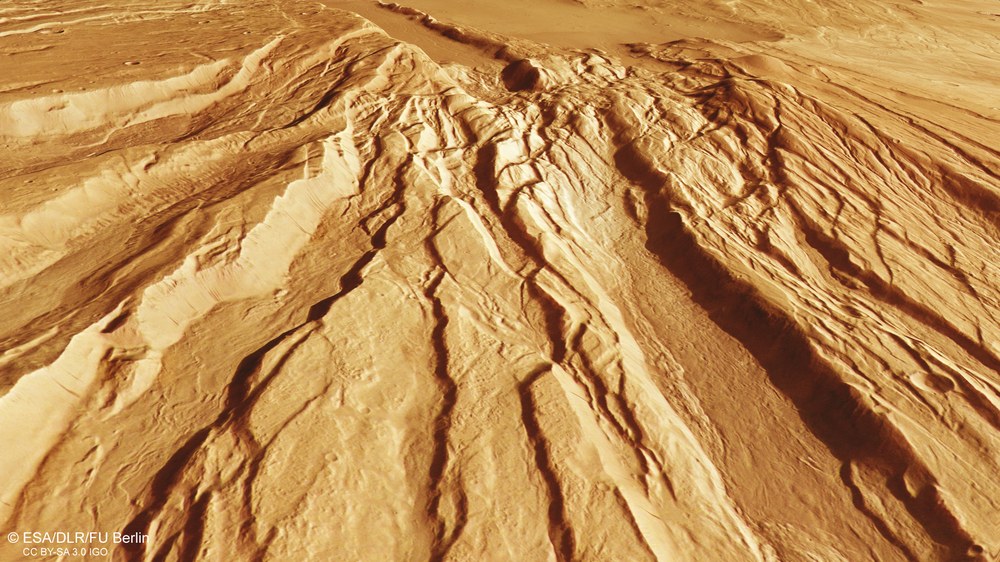
Tectonic graben structures in Acheron Fossae
Acheron Fossae is a region approximately 800 kilometres in length, shaped by pronounced tectonic extension forces and located north of the massive shield volcano Olympus Mons. To the south, the edge of the graben system transitions into lower-lying plains. Acheron Fossae exhibits a typical horst-and-graben surface structure, which formed more than 3.7 billion years ago due to crustal deformation. Several parallel tectonic faults caused blocks of crust to sink between the remaining elevated flanks – the grabens between the horsts.
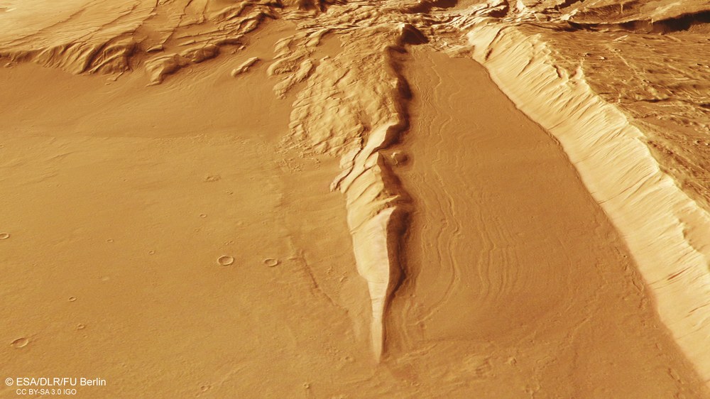
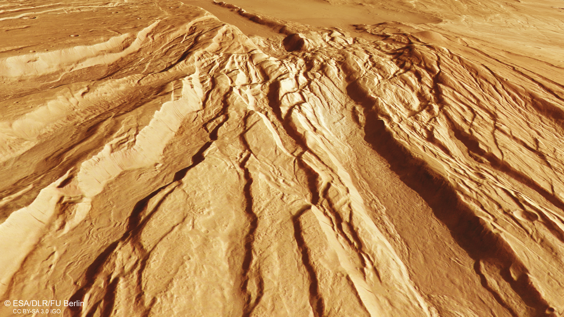
Glacial debris and lava deposits in Acheron Fossae
In the south (foreground), the nearly linear horst-and-graben structures running northwest to southeast transition into a lower-lying plain. Around the spur extending into the plain, meandering flow features are visible. These are believed to consist of debris and rocks moving on the surface of a rock glacier, which advanced plastically into the foreland and then deposited the debris as it melted. On the left side of the image, there are remnants of a glacier tongue that probably spread into the plain near the valley mouth, over a surface of thin, solidified lava.
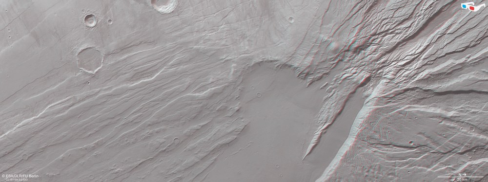
Anaglyph images are generated from the nadir channel of the DLR-operated HRSC camera on ESA's Mars Express spacecraft, which is directed vertically on to the surface of Mars, and one of the four oblique stereo channels. When using red-blue or red-green glasses, these images provide a three-dimensional view of the landscape and give the viewer a spatial idea of the differences in altitude. Such a view provides an excellent opportunity to examine subtle topographic details, such as flow structures at the edges of Acheron Fossae or the horst-and-graben pattern of tectonic extension fractures.
The High Resolution Stereo Camera (HRSC) has captured new images of the Acheron Fossae region on Mars.
A characteristic horst-and-graben structure was formed in this region over 3.7 billion years ago.
During Mars's geologically active period, extensional forces in the crust caused masses to sink along faults.
Focus: Space, Mars
The 'horst' geological feature is a familiar term in the mining industry, where it describes fault structures in coal seams surrounded by rock. However, such formations are not only found deep beneath Earth's surface – they also occur on Mars. Image data acquired by the High Resolution Stereo Camera (HRSC) on board ESA's Mars Express mission show the eastern edge of Acheron Fossae, a tectonic graben system. HRSC is a camera experiment developed and operated by the German Aerospace Center (Deutsches Zentrum für Luft- und Raumfahrt; DLR).
The Acheron Fossae graben system stretches for approximately 800 kilometres and is located around 1200 kilometres north of the massive shield volcano Olympus Mons. The terrain extends in an inverted crescent shape to the north of the Olympus Mons Aureole – a vast, fan-shaped structure composed of landslide deposits that spread down the flanks of the volcano like a blanket. The HRSC image shows the eastern part of this region, where the edge of the graben system transitions into lower-lying plains. The area is named after Acheron – the 'river of pain' in Greek mythology that flows into the underworld.
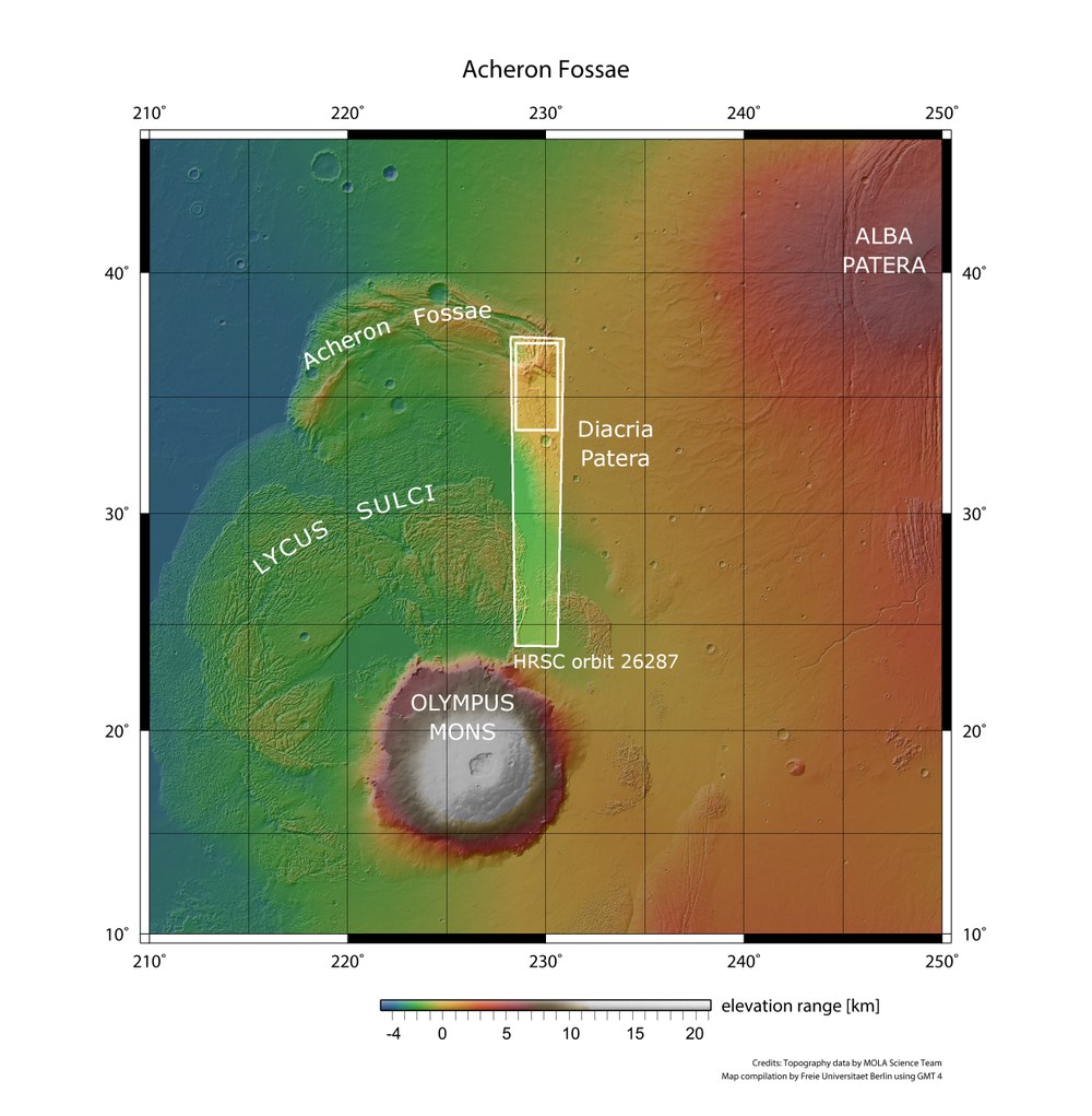
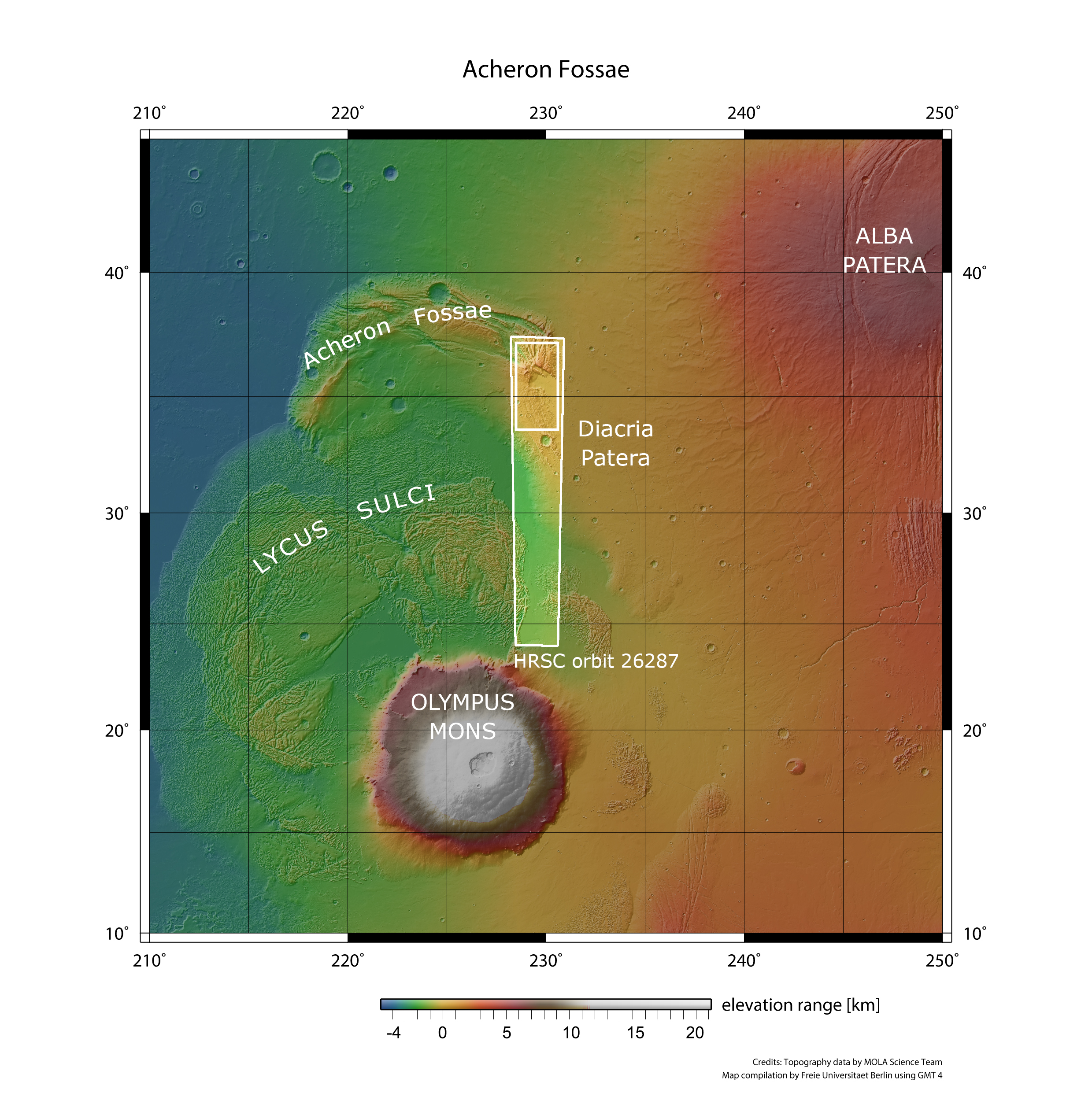
Overview map of the Acheron Fossae north of Olympus Mons
With a diameter of 600 kilometres and a height of approximately 22 kilometres, Olympus Mons is the largest volcano in the Solar System. Now inactive, this shield volcano marks the northwestern boundary of the Tharsis region (to the south and east) and the northern lowlands (to the north and west). Tharsis itself is a volcanic raised plateau roughly the size of Europe and up to six kilometres high. To the north of Olympus Mons lies the crescent-shaped aureole of Acheron Fossae, a region characterised by striking tectonic extension fractures. The landscapes shown in this article are located in the small rectangular area in the northern portion of the HRSC image (large rectangle) acquired during orbit 26,287 of ESA's Mars Express mission.
Credit:
NASA/PL (MOLA Science Team); FU Berlin (using GMT4)
Acheron Fossae features a typical horst-and-graben surface structure, formed due to crustal deformation during Mars's Noachian period, more than 3.7 billion years ago. Several parallel tectonic faults caused crustal blocks to sink on both sides of the fractures. These opposing movements indicate extensional forces in the crust during the planet's geologically active era, and may also be linked to the uplift of the nearby Tharsis region, which caused significant stress in the Martian crust. Over time, the grabens were filled with various materials, including glacial and volcanic deposits.
Unlike Earth, Mars is a single-plate planet. Its tectonic processes are triggered solely by internal stresses, such as those caused by volcanic activity. Analysing the topography and geological formations of tectonic structures provides valuable insights into the properties of the planet's crust and upper mantle.
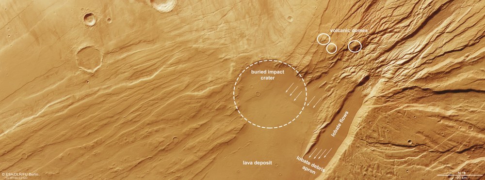
While the lower-lying plains exhibit a smooth surface, the graben system is rugged and covered with impact craters. A closer look reveals that from the heads of two valleys stretching northeast to southwest, a layer of slightly darker material appears to have flowed into the plains – these are referred to as 'lobate flows' in the annotated image below. The flow patterns on the surface suggest that these are the remnants of rocky or debris-covered glaciers that are likely to have slid down the long valley flanks, converged on the valley floor and overlapped in places, forming a linear pattern typical of glacial landscapes. These overlapping features also reveal the direction of flow. The arrows in the image point to the remains of the former glacier tongues.
Geological diversity on the eastern edge of Acheron Fossae
This image highlights several geological features, including the southern extensions (north is to the right in the image) of the prominent Acheron Fossae graben structures. Lava deposit: areas covered by lava flows; Buried impact crater: an ancient impact crater largely covered by newer material; Volcanic domes: three cone-shaped mountains up to 2000 metres high, which may be remnants of ancient volcanoes; Lobate flows: meandering flow features formed by debris transported on the surface of plastically flowing glaciers; Lobate debris apron: the flow front of a former rock glacier, similar to a terminal moraine.
The other material covering the plain appears somewhat lighter in colour and shows more impact craters on its surface. No signs of viscous flow patterns are seen here. Researchers interpret this deposit as lava flows from Alba Patera, one of the large shield volcanoes on Mars, located east of Acheron Fossae. The lava has filled and partially buried a 30-kilometre-wide impact crater at the centre of the image, leaving only half of its rim visible.
Another interesting feature in the HRSC image is a group of three cone-shaped peaks, each several kilometres high. These formations may be small volcanic domes formed by rift-related volcanism in the region. The volcanic activity may have been driven by the local ascent of smaller magma chambers along weak crustal zones. Some of the volcanic domes are intersected by faults, indicating tectonic activity that occurred after their formation.
Image processing
The images were acquired by the High Resolution Stereo Camera (HRSC) on 28 October 2024 during Mars Express orbit 26,287. The ground resolution is approximately 17 metres per pixel and the image is centred at around 230 degrees east and 36 degrees north. The colour image was created with data from the HRSC's nadir channel – the field of view oriented perpendicular to the Martian surface – and the colour channels of the HRSC. The oblique perspective view was created from the digital terrain model (DTM), the nadir channel and the colour channels of the HRSC. The anaglyph image, which conveys a three-dimensional impression of the landscape when viewed with red-blue or red-green glasses, was derived from the nadir channel and a stereo channel. The colour-coded view is based on a DTM of the region, from which the topography of the landscape can be derived. The reference body for the HRSC DTM is the Mars equipotential surface (areoid).
Map server
To download the released raw images and DTMs of the region in GIS-compatible formats, follow this link to the map server
The High Resolution Stereo Camera was developed at the German Aerospace Center (DLR) and built in cooperation with industrial partners (EADS Astrium, Lewicki Microelectronic GmbH and Jena-Optronik GmbH). The science team, led by Principal Investigator (PI) Daniela Tirsch, consists of 50 co-investigators from 35 institutions across 11 nations. The camera is operated by the DLR Institute of Planetary Research in Berlin-Adlershof.
