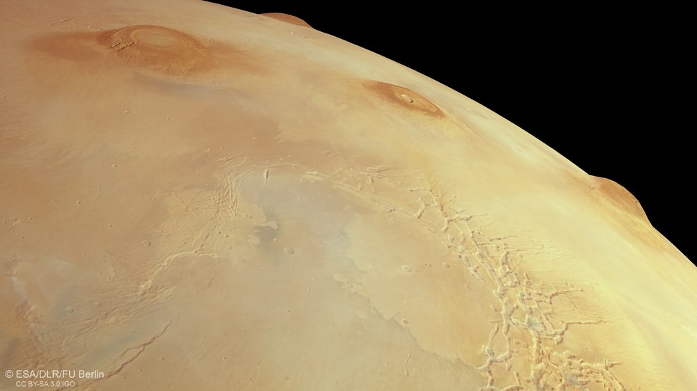
Mars Express has been orbiting the 'Red Planet' for more than 20 years. On 19 October 2023, the HRSC camera system, developed and operated by the DLR Institute of Planetary Research, scanned Mars from the southern highlands to the northern lowlands during orbit 25,000. A digital terrain model was calculated using topography data from the MOLA laser altimeter, from which it was possible to create this triply exaggerated true-colour perspective view of the Tharsis region with the large shield volcanoes (from south to north) Arsia Mons, Pavonis Mons, Ascraeus Mons and (on the horizon) the 22-kilometre-high Olympus Mons. The tectonic trenches of Noctis Labyrinthus can be seen at the bottom right, just east of the volcanoes.
The spectacular Mars as seen during Mars Express orbit 25,000
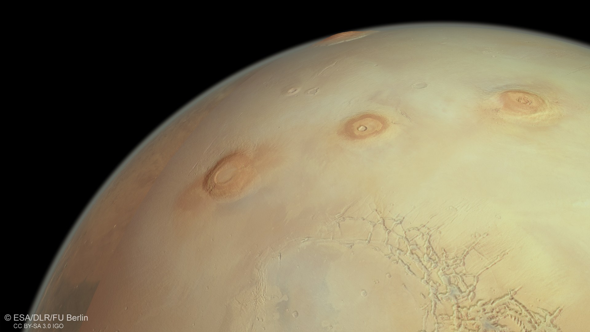
The European Mars Express spacecraft orbits our planetary neighbour Mars once every seven hours. During orbit number 25,000 in October 2023, the HRSC stereo camera captured a particularly impressive image, which covers the cloud-covered highland regions of the southern hemisphere all the way to the northern lowlands. In the centre of the image is the Tharsis region, a bulge measuring over four kilometres in height, on which four of the largest shield volcanoes on Mars tower 12 to 22 kilometres into the sky. The Martian moon Phobos was also captured over the southern highlands during its orbit around Mars and is visible as a small dark dot in the image.
3D anaglyph image of the HRSC image in orbit 25,000
This anaglyph image was generated from the nadir channel of the DLR-operated HRSC camera system on board ESA's Mars Express spacecraft, which is directed vertically onto the surface of Mars, and from terrain information from the MOLA laser altimeter. Using red-blue or red-green glasses, it provides a three-dimensional view of the landscape and give the viewer a comprehensible impression of the differences in altitude.
A new, wide-angle image, acquired by DLR's HRSC Mars camera, offers a sweeping view of volcanoes in the province of Tharsis and the canyons of Noctis Labyrinthus.
The image data was acquired from a distance of 10,500 kilometres and combined with a terrain model based on NASA's MOLA laser measurements.
Focus: Spaceflight, Solar System exploration, Mars
The European Mars Express spacecraft orbits Earth's planetary neighbour, Mars, once every seven hours. It has been doing so for more than 20 years. During orbit number 25,000, the High Resolution Stereo Camera (HRSC), developed by the German Aerospace Center (Deutsches Zentrum für Luft- und Raumfahrt; DLR), acquired another special image that extends from the cloud-covered highland regions of the southern hemisphere to the northern lowlands.
The image offers a sweeping view of one of the most geologically interesting areas on Mars: the Tharsis region. The Tharsis plateau is enormous – with an area of approximately 25 million square kilometres, it covers an area roughly the size of the North American continent. Four of the largest Martian volcanoes rise into the sky there. From north to south, these are the 'shield' volcanoes Olympus Mons, standing 22 kilometres tall, as well as the group of three referred to as Tharsis Montes – Ascraeus Mons (18 kilometres), Pavonis Mons (12 kilometres) and Arsia Mons (14 kilometres).
Volcanic giants, a rift valley and the Martian moon Phobos
The Tharsis region is an enormous dome more than four kilometres high. Its name comes from the ancient city of Tartessus in present-day Andalusia – the subject of myths for more than 2000 years.
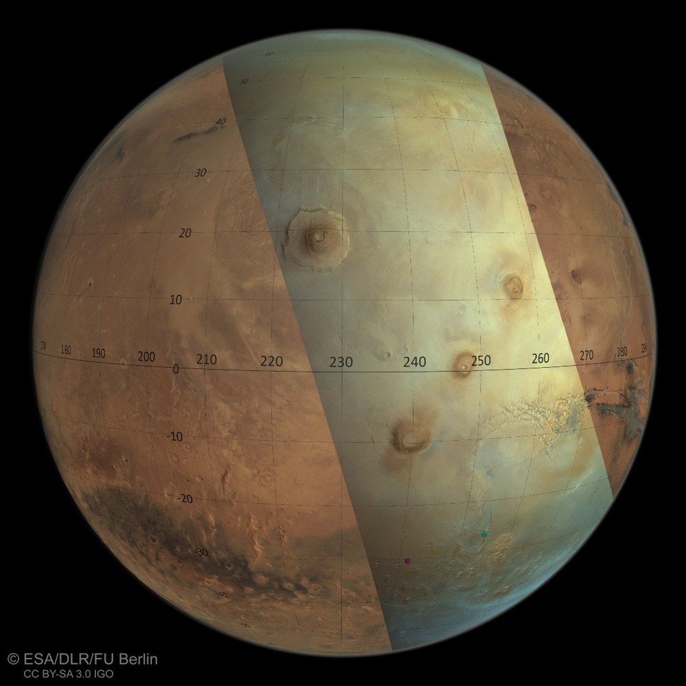
The HRSC team – responsible for planning the acquisition of this wide-angle image – even managed to capture the Martian moon Phobos passing in front of the Red Planet in this partial view. Less than 30 kilometres in size and the innermost of Mars’ two companions (the 15-kilometre Deimos orbits further out), it circles the planet approximately every eight hours at an altitude of 6000 kilometres – similar to Mars Express. In the full planet view (a colour composite of red, green and blue) with latitude and longitude information, the moon can be seen three times, once red, then yellow and finally a green dot, showing where Phobos was when data was recorded in each colour ‘channel’, taken one after the other.
Phobos is the target of the Japanese-European MMX mission which is expected to set off for the Martian system in 2026, place a rover on the smaller moon for the first time in 2029 and bring samples back to Earth in 2031.
Field of view of DLR's HRSC camera over Mars in orbit 25,000
ESA's Mars Express spacecraft follows a polar orbit, so it ‘circles’ Mars on a path that takes it over its north and south poles on every orbit. As it does so, it moves along an ellipse. During each seven-hour orbit, Mars Express approaches the Red Planet's surface, getting as close as approximately 350 kilometres from the surface. It then moves away again to a distance of around 10,500 kilometres. Images acquired from this high altitude are generally used to observe the weather in the thin Martian atmosphere or to create global views of the planet’s surface, and for calibration purposes. The spacecraft is ‘slewed’, or tilted, over Mars in a sweeping motion, allowing the HRSC sensors to scan very large areas.
The Mars Express spacecraft follows a polar orbit, so it 'circles' Mars on a path that takes it over its north and south poles on every orbit. As it does so, it moves along an ellipse. During each seven-hour orbit, Mars Express approaches the Red Planet’s surface, getting as close as approximately 350 kilometres from the surface. It then moves away again to a distance of around 10,500 kilometres.
Images acquired from this high altitude are generally used to observe the weather in the thin Martian atmosphere or to create global views of the planet's surface, and for calibration purposes. The spacecraft is ‘slewed’, or tilted, over Mars in a sweeping motion, allowing the HRSC sensors to scan very large areas. The field of view of the spacecraft's 'line' sensors, which are arranged at right angles to the flight path, is swept across the surface like a broad brushstroke. During an HRSC image acquisition, all sensors scan the surface one after the other at the same angle, resulting in a time interval between each colour channel.
This can be seen in the overview image, where Phobos is seen in three different places and colours as it moved during the scanning process. In the post-processing of such images, individual colour images are superimposed to create this complete colour view. Stationary landscape features on Mars’ surface easily coincide across several scans taken at different times. This is more difficult in the case of fast-moving Phobos in orbit. Here, the images have to be reconstructed individually in order to obtain a uniform impression of the scene.
The Tharsis region covers just over a sixth of the surface of Mars. Smaller volcanoes such as Jovis Tholus, Biblis Patera and Ulysses Patera can also be seen in the image. The branched canyons of Noctis Labyrinthus, the western extension of the huge Valles Marineris rift valley system, are located at the bottom right of the image. Many other surface features should also be emphasised, such as the wrinkled landscape of Lycus Sulci, north of Olympus Mons, or the tectonic graben systems Tantalus Fossae, Ceraunius Fossae and Ulysses Fossae.
If one zooms in on the image, many other details become apparent. For example, lee wave clouds can be recognised in the lower part of the image. These form on the 'lee' sides of topographical obstacles such as mountains or crater rims, facing away from the wind. When air flows over a ridge and rises, it is accelerated. The air flow, consisting of different layers, then forms a wave-like structure on the leeward side of the obstacle. Another narrow, presumably dust-laden cloud band is located to the south of Solis Planum.
Four of the tallest volcanoes in the Solar System
The three large Tharsis volcanoes Arsia Mons, Pavonis Mons and Ascraeus Mons (from left to right) and the tallest volcano in the Solar System, the 22 kilometre tall Olympus Mons, look like gigantic insect bites on the 'skyline' of the Tharsis bulge, a volcanic region on the Martian equator that was active billions of years ago. The tectonic rift valleys of Noctis Labyrinthus can be seen east of the Tharsis volcanoes, whose continuation outside the image forms the Valles Marineris trenches, which are over 4000 kilometres long and ten kilometres deep.
These images were created using data acquired by the High Resolution Stereo Camera (HRSC) on 19 October 2023 during Mars Express orbit 25,000. The ground resolution is less than 450 metres per pixel and the image is centred at approximately 248 degrees east and two degrees north. The colour image was created from data acquired by the nadir channel – the field of view of aligned perpendicular to the surface of Mars – and the colour channels. The context maps are based on HRSC data and data from the Mars Orbiter Laser Altimeter (MOLA) experiment on board NASA's Mars Global Surveyor (MGS) mission. The oblique perspective view was generated from a digital terrain model created using data from MOLA, the HRSC nadir channel and the HRSC colour channels. The anaglyph image, which gives a three-dimensional impression of the landscape when viewed with red/blue or red/green glasses, was derived from information in the MOLA digital terrain model and from the HRSC nadir channel.
The High Resolution Stereo Camera (HRSC) was developed at the German Aerospace Center (DLR) and built in cooperation with industrial partners (EADS Astrium, Lewicki Microelectronic GmbH and Jena-Optronik GmbH). The science team, led by Principal Investigator (PI) Daniela Tirsch from the DLR Institute of Planetary Research, consists of 50 co-investigators from 35 institutions and 11 nations. The camera is operated by the DLR Institute of Planetary Research in Berlin-Adlershof.


