Flying in tandem with the Biomass satellite – aircraft radar measurements over Gabon's rainforests
December 3, 2025 | Determining forest biomass using radar
Flying in tandem with the Biomass satellite – aircraft radar measurements over Gabon's rainforests
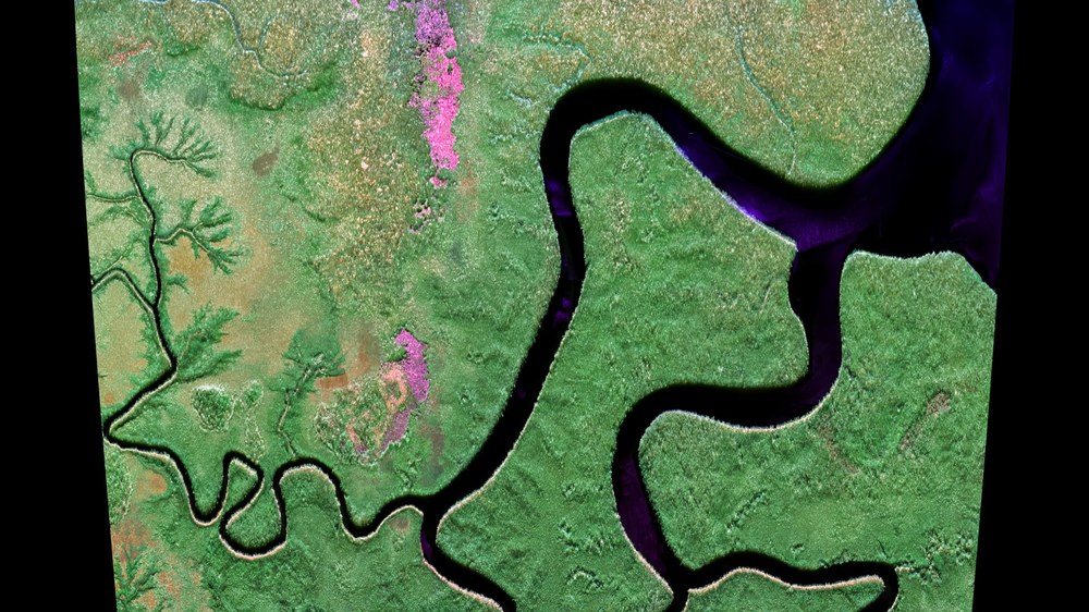
Polarimetric F-SAR radar image acquired in the P-band
In November 2025, the DLR Microwaves and Radar Institute acquired dedicated images of the tropical rainforests in Gabon. Researchers are using the data from the GABONX flight campaign to compare them with synchronously acquired data from ESA’s new Biomass Earth observation satellite – so that its radar system can be correctly calibrated and deliver highly accurate data in future. The area shown, Pongara, is part of an extensive river delta and consists mainly of very tall mangrove and swamp forests. Owing to the richness of its fauna, the region is designated as a national park.
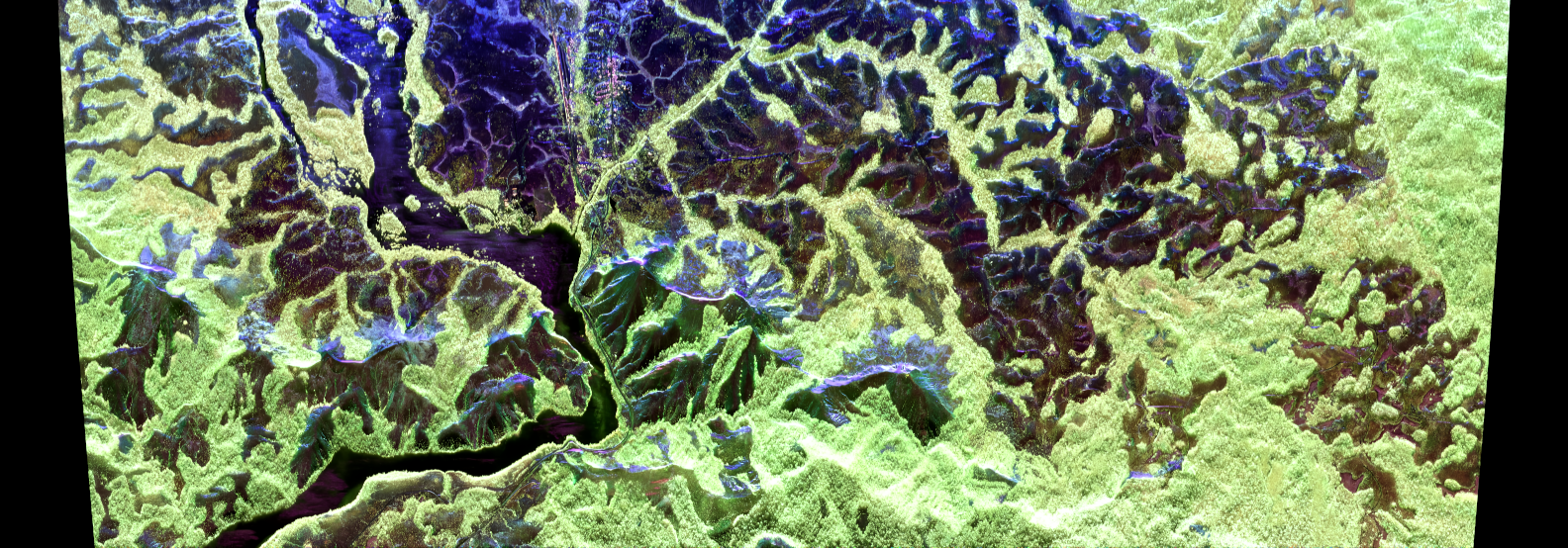
Lopé National Park, Gabon: airborne radar image in the P-band
Polarimetric F-SAR radar image acquired in the P-band. The image shows the transition from rainforest to savanna in Lopé National Park in central Gabon. Because of its highly diverse vegetation and wildlife, the area has been inscribed on the UNESCO World Heritage List.
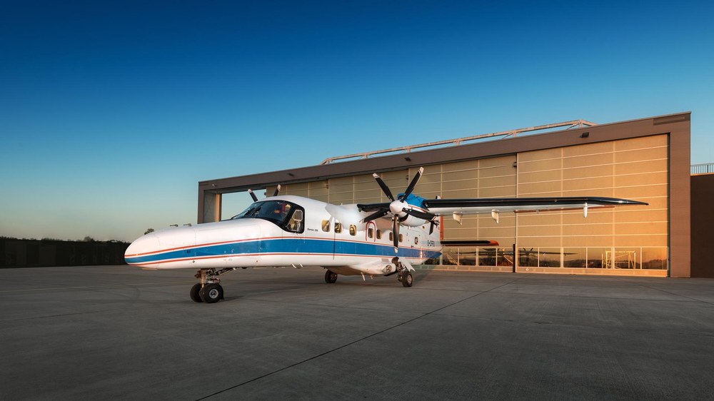
The DLR DO 228-212 research aircraft (registration D-CFFU) is robust, reliable and specially modified for extensive scientific payloads. It serves as a measurement and test platform in particular for remote sensing, Earth observation and transport research, as well as for testing innovative radar systems. Its two powerful turboprop engines also allow operations from unpaved runways. The DO 228-212 D-CFFU is operated by the DLR Flight Experiments facility in Oberpfaffenhofen.
Simultaneous flights between DLR's Dornier DO 228-212 D-CFFU research aircraft and the ESA Biomass satellite were successfully carried out over tropical rainforest; the aim is to determine forest biomass using radar.
With the measurement data, the DLR Microwaves and Radar Institute is making a significant contribution to the calibration and validation of Biomass, the world's first P-band radar satellite.
Focus: Space, Earth observation, radar technology
In recent weeks, the skies above Gabon in Central Africa have been the setting for a special alliance: a research aircraft from the German Aerospace Center (Deutsches Zentrum für Luft- und Raumfahrt; DLR) has been taking radar images of the rainforest – flying paths simultaneously with the European Space Agency's (ESA) Biomass Earth observation satellite. The measurement flights of the Dornier DO 228-212 D-CFFU were precisely coordinated with the overflights of the new satellite, which has been orbiting Earth since April to determine global forest biomass using radar. The DLR team acquired the radar images from the air using their specially developed F-SAR airborne radar. These data will now be compared with the satellite measurements to assess calibration quality and Biomass performance. The researchers' aim is to support global climate protection with state-of-the-art radar technology.
ESA's Biomass mission aims to precisely determine the total mass of living material – the 'biomass' – of our forests worldwide for the first time. This knowledge is fundamental to our ability to calculate how much climate-relevant carbon dioxide (CO2) is absorbed and stored by forests, and released through deforestation. Only with these accurate figures can global warming forecasting models be improved and targeted measures taken against climate change and its consequences.
Unique, high-quality data
To ensure high data quality from Biomass, the satellite's radar system must be precisely calibrated and validated. This is where the specially equipped Dornier DO 228-212 D-CFFU came into play: with the F-SAR sensor on board, the DLR research aircraft provided reference measurements by recording data shortly after the satellite passed over the same forest areas and with the same radar look direction. The data comparison will enable the subsequent 'fine-tuning' of the satellite. Accordingly, the airborne F-SAR radar from the DLR Microwaves and Radar Institute was also adjusted and checked in advance. Near DLR's site in Oberpfaffenhofen, researchers have their own calibration field with precisely surveyed radar reflectors, as large as five metres in size, as reference points.
The biomass of tropical rainforests can be determined precisely thanks to state-of-the-art SAR (Synthetic Aperture Radar) technology and the use of very long radar waves. The Biomass mission is the world's first radar satellite to operate in the 'P-band' – with a wavelength of approximately 70 centimetres. The advantage of these relatively long radar waves is that they can penetrate deep into vegetation, down to the forest floor – far deeper than has been possible with previous radar-based Earth observation satellites, which have usually been designed for wavelengths in the range of a few centimetres. In addition, Biomass uses a special imaging technique called polarimetric tomography, which enables it to provide information about all layers of the forest structure. This data will provide scientists with important new insights into the global forest ecosystem and in coming years should prove essential for accurately calculating global warming.
Many years of experience
With 88 percent of its territory covered by rainforest, Gabon offers ideal conditions for research into determining biomass. DLR had already carried out measurements in Gabon in 2016 and 2023 using the same F-SAR sensor. Now, the re-survey of the test areas from that time aims to identify and quantify changes in the biomass and structure of Gabon's forests.
For the flight measurements, the radar antenna was mounted on the side of the DLR research aircraft and on the underside in the F-SAR antenna carrier. The robust and reliable DO 228-212 D-CFFU is operated by the DLR Flight Experiments facility in Oberpfaffenhofen and enables a wide range of scientific missions – from Earth observation campaigns to synchronous flight with a satellite. The DLR flight campaign was led in cooperation with the Gabonese space agency AGEOS (Agence Gabonaise d'Études et d'Observations Spatiales) on behalf of the European Space Agency (ESA).
With the successful completion of the flight campaign, the crucial scientific phase can now begin as researchers at the Microwaves and Radar Institute process the data. Flight campaign data will then be compared with the data recorded synchronously by the Biomass satellite, so that its SAR system can be correctly adjusted to deliver highly accurate data in future.
Biomass is the first Earth observation satellite of the European Space Agency (ESA) with the goal of mapping the global biomass of forests. This will help improve our understanding of the carbon cycle and determine the carbon storage capacity of forests. The radar mission is unique in operating its radar sensor in the long-wavelength P-band and in using a fully polarimetric, multi-angle imaging concept. Biomass was successfully launched on 29 April 2025 from the European spaceport in French Guiana. It is currently in its commissioning phase, during which its radar images are being calibrated and validated.
Germany contributes more than 20 percent to the Biomass mission and is also responsible for key technological work packages, including the development of the radar instrument and central electronics by Airbus Defence and Space. Additional German companies involved in the mission include DSI Aerospace, OHB System, ArianeGroup, TESAT-Spacecom, United Monolithic Semiconductors, Rockwell Collins and the Center for Applied Space Technology and Microgravity (ZARM) at the University of Bremen. A project office has also been set up at the Max Planck Institute for Biogeochemistry in Jena to coordinate the scientific use of the mission. Working closely with the University of Jena, DLR and the Helmholtz Centre for Environmental Research, it supports the national and international user community by preparing information, identifying gaps and promoting exchange – for example, through webinars, summer schools and tutorials. The German Space Agency at DLR coordinates these contributions.

