June 10, 2025 | DLR method for detecting burnt areas licensed
Help fighting forest fires from space
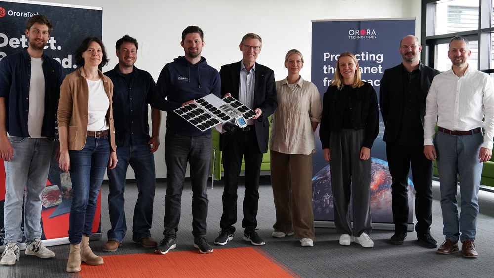
Group photo – DLR and OroraTech sign licensing agreement
DLR's Earth Observation Center (EOC) and OroraTech have been working together for years on automated fire detection and classification. In this group photo, Martin Langer (centre left), CEO of OroraTech, and Stefan Dech, Director of DLR's German Remote Sensing Data Center, hold a model of an OroraTech fire detection satellite.
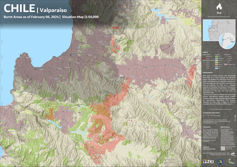
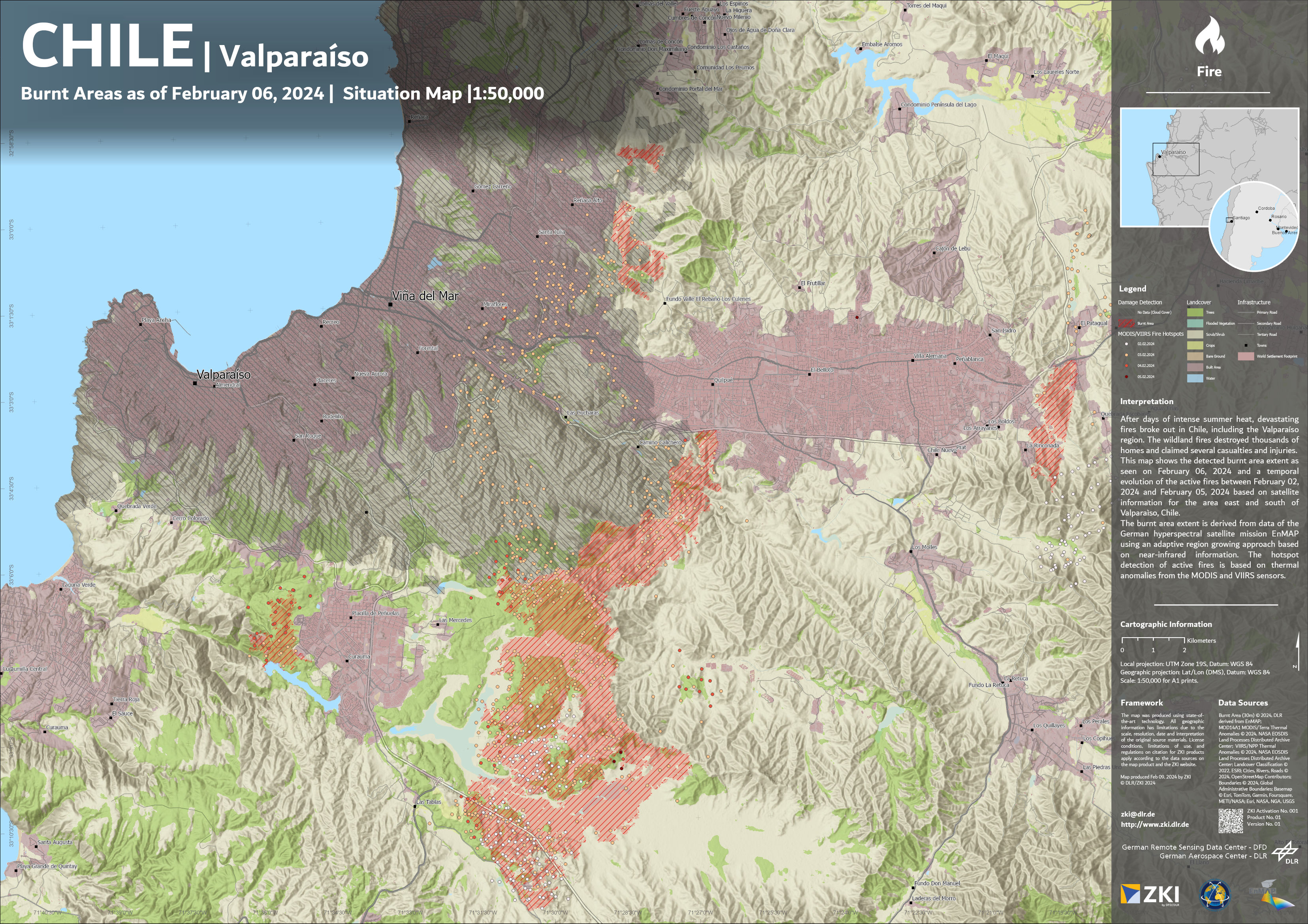
This map shows the large wildfire that occurred in February 2024 in the vicinity of Valparaíso in Chile. For the analysis, DLR's Earth Observation Center used data from the German environmental satellite EnMAP along with the method now licensed to OroraTech.
An AI-powered method for rapidly detecting and monitoring burned areas using satellite data has been licensed by DLR to Munich-based Earth observation company OroraTech.
The method will be integrated into OroraTech's Wildfire Solution platform to support users worldwide in real-time situational awareness.
Focus: Space, Earth observation, technology transfer
When forests are on fire, time is of the essence. Researchers at the German Aerospace Center (Deutsches Zentrum für Luft- und Raumfahrt; DLR) have developed a method for identifying and continuously monitoring fire areas in real time. The DLR Earth Observation Center (EOC) has now licensed this method to Munich-based NewSpace company OroraTech. The company specialises in monitoring wildfires from space and will integrate the method into its commercial Wildfire Solution platform.
Near real-time analysis using satellite data and AI
Every year, wildfires affect approximately 400 million hectares of land worldwide – an area roughly ten times the size of Germany. They can have devastating effects on people, wildlife and infrastructure, so early detection and rapid assessment of the extent of damage are essential. In recent years, DLR has developed a robust method for analysing areas affected by fires in real time using heterogeneous optical satellite data. This method is now licensed for use by OroraTech.
DLR's method for evaluating Earth observation data works in two stages. First, a 'superpixel segmentation algorithm' groups neighbouring pixels with similar characteristics. Then, these pixel groups are classified using deep learning techniques. This method enables burnt areas to be derived from datasets with high precision and speed – supporting a wide range of optical sensors on different Earth observation satellites with varying spatial resolution. Data from different satellites is also merged to continuously refine the results during active fire monitoring. This analysis method was recently published in the journal GIScience & Remote Sensing.
Industry-oriented and practical
The collaboration between DLR and OroraTech has grown steadily since the company was founded in 2018. Joint fire and wildfire-related projects, a 2024 research cooperation agreement and several ongoing project proposals are just some of the milestones in a relationship that will be expanded by the current licence agreement.
"Trusted cooperation with small- and medium-sized companies like OroraTech is very important to us, allowing DLR's research developments to be translated into concrete applications and tested for real-world usability," emphasises Stefan Dech, Director of the German Remote Sensing Data Center at DLR. Dech adds that, in addition to the EOC's research work, technical expertise in real-time data reception from Earth observation satellites will also be incorporated at the DLR site in Neustrelitz.
By incorporating DLR's licensed analysis method in its Wildfire Solution platform, OroraTech will enable users worldwide to better assess dangerous situations. "The global intensification of forest fire risk calls for swift, decisive action – and the fusion of diverse data streams and products in a form that can be quickly and easily understood," explains Martin Langer, Chief Executive Officer of OroraTech. "This collaboration between OroraTech, a pioneer in this field, and DLR, one of the world's leading research institutions, is a unique opportunity for our customers to benefit from the latest scientific advances."
