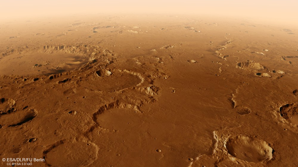
Virtual flight over the southern Martian highlands
Flaugergues crater, a vast impact structure, can be seen at the centre-left edge of the image.
Image: 1/2, Credit:
ESA/DLR/FU Berlin/NASA/MSSS
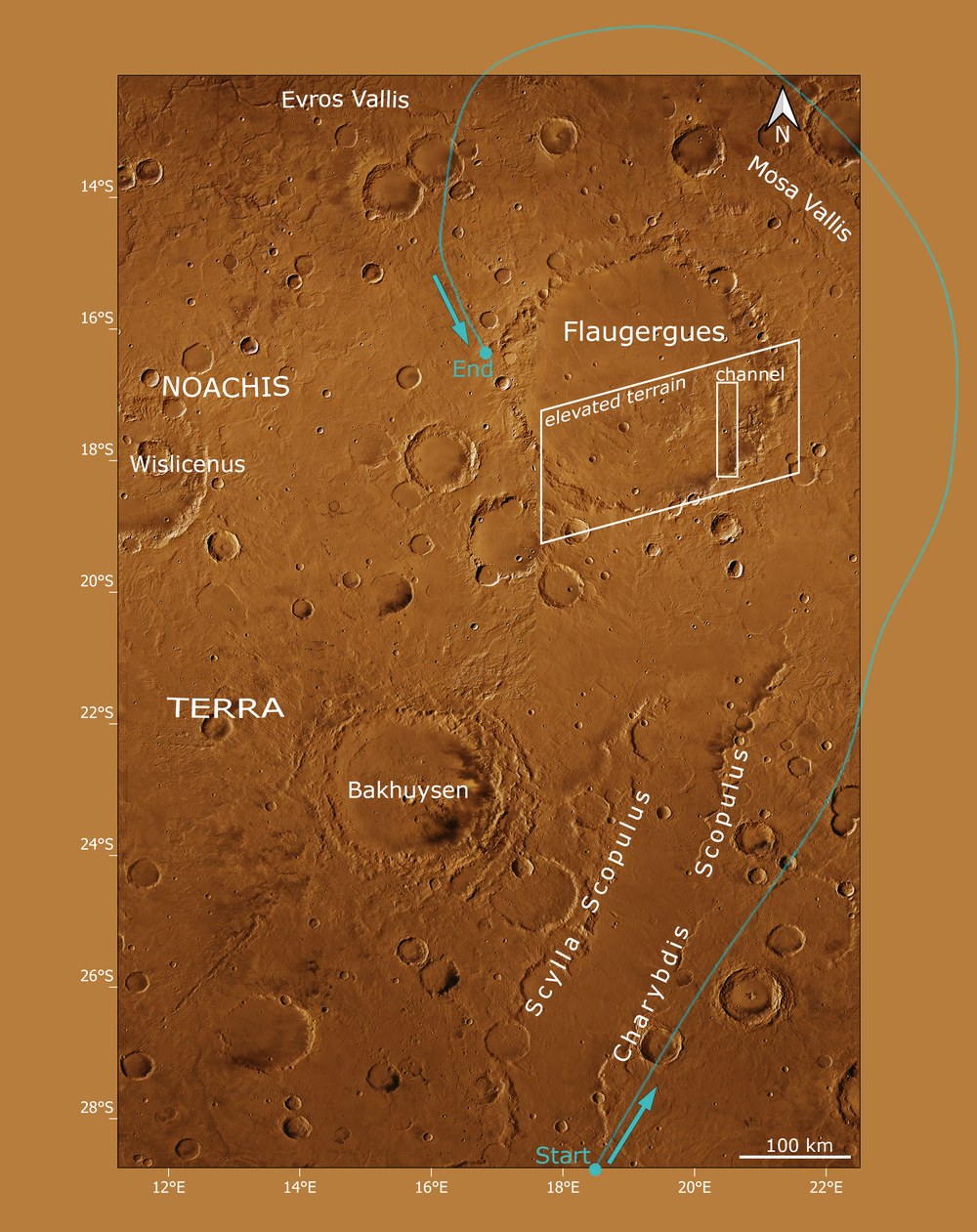
Around the Flaugergues crater on Mars – the trajectory
Image: 2/2, Credit:
ESA/DLR/FU Berlin
A new video shows a virtual flyover of the Martian ‘Flaugergues’ crater.
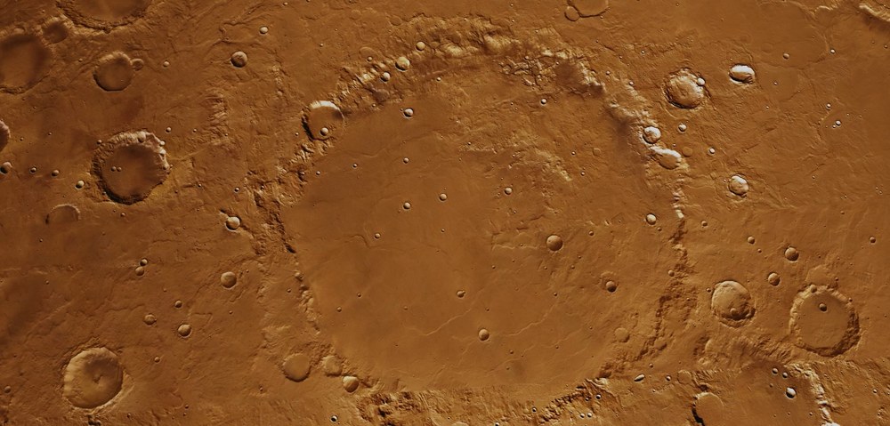
This impact structure is 245 kilometres in diameter and is located in the southern Martian highlands.
The film was created using an image mosaic from DLR’s High Resolution Stereo Camera (HRSC) on board the Mars Express mission.
Since 2004, HRSC image data has been used to generate three-dimensional terrain models of the Martian landscape.
These models make it possible to reconstruct geological processes from the planet’s early history.
Focus: Spaceflight, exploration, Mars
A virtual flight around a vast impact crater – this new video focuses on a striking formation in the middle of the southern Martian highlands. The Flaugergues crater has a diameter of 245 kilometres, roughly as wide from east to west as Belgium. The basis for the animation is image data from the High Resolution Stereo Camera (HRSC) on board ESA's Mars Express mission. HRSC is a camera experiment developed by the German Aerospace Center (Deutsches Zentrum für Luft- und Raumfahrt; DLR) and has been orbiting Mars since January 2004.
The digital terrain models derived from its image data enable the three-dimensional visualisation of Mars's landscape and the quantification of geological processes – as surface features can be measured with high precision. This makes it possible to reconstruct geological processes from the early history of the Solar System – something not possible on the dynamically changing Earth.
Large-scale impact craters have helped to date large parts of the southern Martian highlands to the Middle Noachian period (up to approximately 3.94 billion years ago). At that time, the Solar System was only half a billion years old, and there were still large asteroids that collided with the bodies of the inner Solar System much more frequently than today. The body that formed the Flaugergues crater is thought to have been between 15 and 25 kilometres in size.
The crater featured in the video was named after the French astronomer Honoré Flaugergues (1755–1835) who became interested in astronomy as a child and, supported by his father, taught himself about our Solar System. Although he never attended university, he later published treatises not only in astronomy, but also in medicine and archaeology.
This animation takes viewers on a journey to a striking structure in the southern Martian highlands. Flaugergues crater, 245 kilometres in diameter, lies amid rugged terrain. The basis for this animation is image data from the High Resolution Stereo Camera (HRSC) on board ESA's Mars Express mission. HRSC is a camera experiment developed by the German Aerospace Center (DLR).
Flyover of Flaugergues crater on Mars
Your consent to the storage of data ('cookies') is required for the playback of this video on Quickchannel.com. You can view and change your current data storage settings at any time under privacy.
Flyover of Flaugergues crater on Mars
This animation takes viewers on a journey to a striking structure in the southern Martian highlands. Flaugergues crater, 245 kilometres in diameter, lies amid rugged terrain. The basis for this animation is image data from the High Resolution Stereo Camera (HRSC) on board ESA's Mars Express mission. HRSC is a camera experiment developed by the German Aerospace Center (DLR).
Credit:
ESA/DLR/FU Berlin/NASA/MSS
The 'flight route'
The flyover begins at Scylla and Charybdis Scopuli, heads north to the eastern side of the Flaugergues crater and then circles it anticlockwise to its western rim. The two scopuli (Latin for rocks) are irregular steep slopes that enclose an elongated, relatively flat depression. It is approximately 75 kilometres wide and up to 1000 metres deeper than the surrounding terrain. The comparatively low density of impact craters within this graben or trench-like structure indicates that it is younger than the surrounding area. At the same time, the morphology suggests that the depression has been filled by volcanic deposits. In one location, remnants of an ejecta blanket can be seen, originating from an impact crater in the east and having been partially deposited in the depression.
To the west, the route passes another large impact crater called Bakhuysen. At 150 kilometres in diameter, it formed approximately 3.7 billion years ago – experts refer to this as the Late Noachian to Early Hesperian period. Next, the Flaugergues crater comes into view. One striking feature is that its floor is not uniformly flat and filled in, as is the case for most other craters of its age. Approximately half of the floor of Flaugergues is dominated by rugged terrain up to 1000 metres high, cut through by a small valley.
In contrast, the northern part of the crater floor is an almost entirely flat plain, interrupted only by a few wrinkle ridges. These ridges indicate that the crater was filled with low-viscosity lava. The elevated terrain was probably deposited from outside the crater after its formation and after the lava filled it in.
Geological dating indicates that this material was deposited at roughly the same time as the material filling the long depression between the two scopuli. The elevated terrain within Flaugergues is morphologically very similar to the surrounding ancient highlands, which is why some geological maps place it chronologically before the lava infill. However, the geological boundary between the two features suggests that the lava fill was deposited earlier and now lies ‘stratigraphically’ beneath the heavily fractured terrain.
Background Information: Image processing
This film was created using an image mosaic from the High Resolution Stereo Camera on board Mars Express. The dataset (Mars Chart HMC20W) was combined with topographic information from the stereo camera's digital terrain model (DTM) to create a three-dimensional landscape. The view is centred at 20 degrees south and 17 degrees east. For each second of the film, 50 individual images are rendered, following a predefined camera path in the scene. The vertical exaggeration used for the animation is threefold. Atmospheric effects such as clouds and haze have been added to obscure the boundaries of the terrain model. The haze begins to build up at a distance of 250 kilometres.
HMC20 products include multi-orbit DTMs and orthorectified image mosaics generated from individual HRSC images, as well as derived products such as pan-sharpened colour mosaics. 'Orthorectification' is the technical term for the geometric correction of an image. This process removes relief distortions, sensor artefacts and other perspective distortions.
The HMC20 data products are organised according to a modified version of the USGS MC-20 tiling scheme of the United States Astrogeology Science Center. All HMC20 products are based on a bundle block adjustment of the stereo images and are registered to the global MOLA reference.
The High Resolution Stereo Camera was developed by the German Aerospace Center (DLR) and built in cooperation with industrial partners (EADS Astrium, Lewicki Microelectronic and Jena-Optronik). The science team, led by Daniela Tirsch, Principal Investigator (PI), consists of 50 co-investigators from 35 institutions in eleven countries. The camera is operated by the DLR Institute of Space Research (formerly the DLR Institute of Planetary Research) in Berlin-Adlershof.