Skip to main content
Skip to navigation
Skip to footer
Press
Accessibility
de
en
DLR
DLR
▾
About us
▾
Organisation
▾
Executive Board & Committees
▾
History of DLR
▾
DLR in numbers
▾
Sustainability
▾
Online-Shop
▾
Institutes & Facilities
▾
German Space Agency at DLR
▾
Programmes & Missions
▾
National Contact Point Space
▾
News
▾
ESA Affairs
▾
DLR Projektträger
▾
Services
▾
Paths to funding
▾
Competence network
▾
Programme Management Agency for Aviation Research
▾
Locations & Offices
Research & Transfer
Research & Transfer
▾
Aeronautics
▾
Strategy & Programme
▾
Featured topics
▾
Projects
▾
Institutes & Facilities
▾
Research infrastructure
▾
News
▾
Space
▾
Strategy & Programme
▾
Featured topics
▾
Projects & Missions
▾
Institutes & Facilities
▾
Research infrastructure
▾
News on Space
▾
Energy
▾
Strategy & Programme
▾
Featured topics
▾
Projects
▾
Institutes & Facilities
▾
Research infrastructure
▾
News on Energy
▾
Transport
▾
Strategy & Programme
▾
Featured topics
▾
Projects
▾
Institutes & Facilities
▾
Research infrastructure
▾
News on Transport
▾
Security and defence
▾
Strategy & Programme
▾
Featured topics
▾
Projects
▾
Institutes & Facilities
▾
Research infrastructure
▾
News on Security and defence
▾
Digitalisation
▾
Strategy & programme
▾
Featured topics
▾
Projects
▾
Institutes & Facilities
▾
Research infrastructure
▾
Quantum Computing Initiative
▾
News on Digitalisation
▾
Innovation & Transfer
▾
Technology portfolio
▾
Types of collaboration
▾
Future topics
▾
Large-scale facilities
▾
News on Innovation & Transfer
▾
DLR_Startup Factory
▾
Research infrastructure at DLR
▾
Large-scale research facilities
▾
Research aircraft fleet
▾
Systemhaus Technik
▾
Featured topics
▾
All topics
▾
Projects & Missions
Latest
Latest
▾
News
▾
Press
▾
Press releases
▾
Events
▾
DLR blog
▾
Social Media
Multimedia
Multimedia
▾
Publications
▾
DLRmagazine
▾
COUNTDOWN Magazine
▾
Brochures
▾
Reports
▾
Miscellaneous
▾
DLR literature search
▾
Videos
▾
Images
Careers & Education
Careers & Education
▾
Jobs and careers
▾
Opportunities for young scientists
▾
DLR_School_Labs
▾
School and youth projects
▾
Traineeships
▾
For the next generation of researchers
▾
Bachelor's and master's thesis projects under the Spanish sun
▾
DLR-DAAD Fellowships
▾
DLR Design Challenge
▾
DLR_Graduate_Program
▾
DLR_Summer_School on Space Propulsion
▾
Scientific parabolic flights
▾
Flying Lecture Theatre
▾
REXUS/BEXUS
▾
Equality at DLR
▾
Diversity Management
▾
Equal opportunities at DLR
>
Research & Transfer
>
Featured topics
>
Fighting wildfires with cutting-edge technology
>
>
High-tech eyes for the airborne situation picture
>
MACS thermal data
Home
>
Research & Transfer
>
Featured topics
>
Fighting wildfires with cutting-edge technology
>
High-tech eyes for the airborne situation picture
>
MACS thermal data
MACS thermal data
MACS thermal data
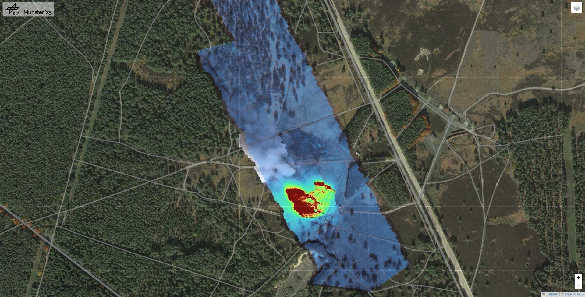
Mapping a wildfire – DLR’s MACS camera delivered this wildfire map, including with thermal images, after flying over the fire area.
Credit:
DLR (CC BY-NC-ND 3.0)
Download
Download