November 2, 2022 | German environmental satellite EnMAP enters routine operations
EnMAP – Ready for science
Towards more sustainable agriculture
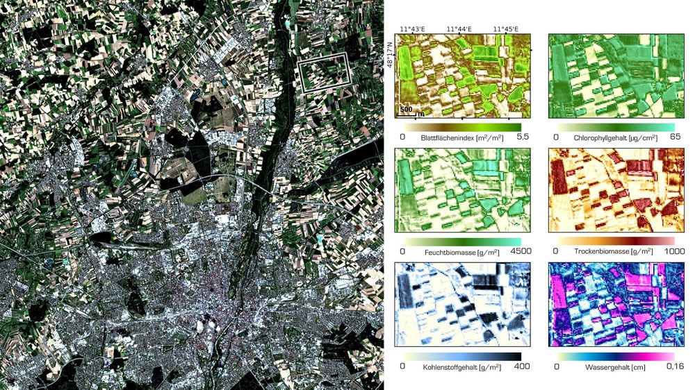
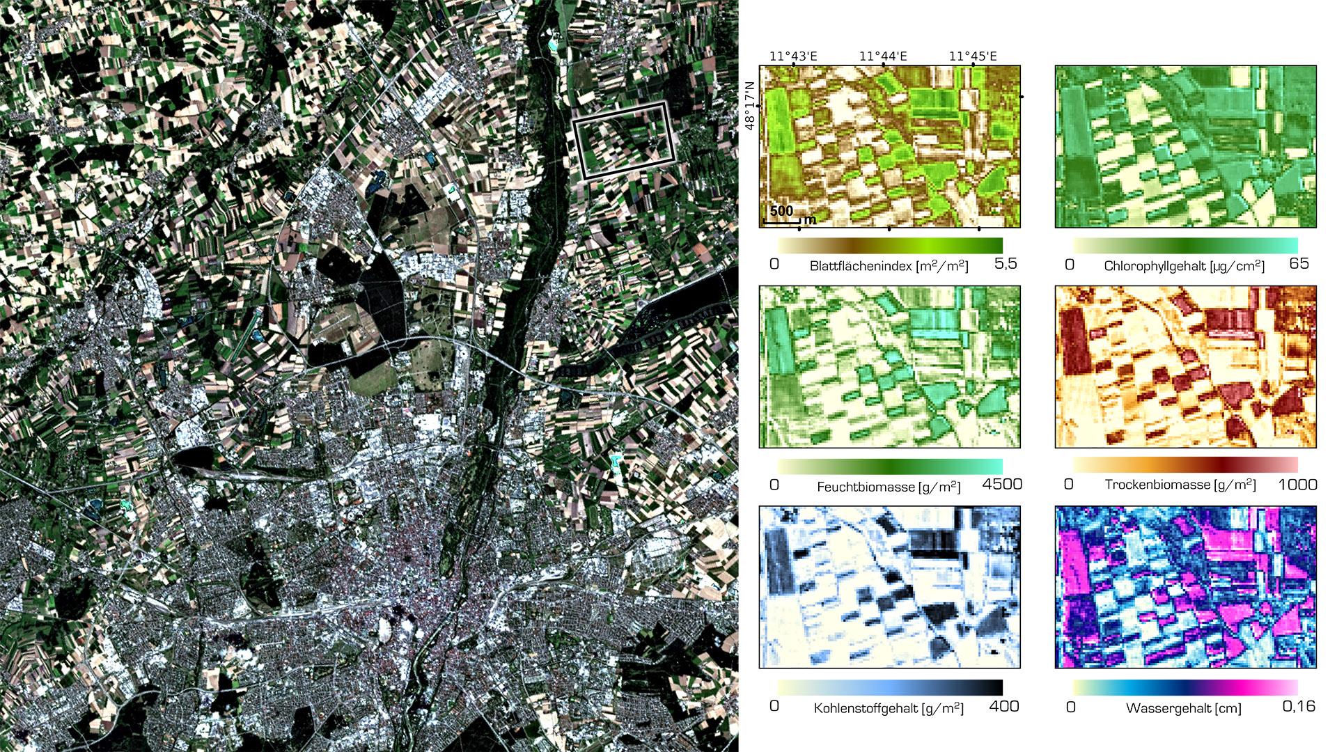
On 28 July 2022, EnMAP acquired an image of the northern area of Munich. Using efficient algorithms and modern machine learning techniques, scientists from the Department of Geography at Ludwig Maximilian University of Munich (LMU) were able to quantify and map biophysical and biochemical plant properties over large areas for the first time. Using this EnMAP data, they have collected information on leaf area index and chlorophyll content, wet and dry biomass, as well as carbon and water content.
Image: 1/4, Credit:
EnMAP Commissioning Phase data 2022 DLR/IGGF GEO LMU München
Tracking down 'tell-tale methane plumes' with EnMAP
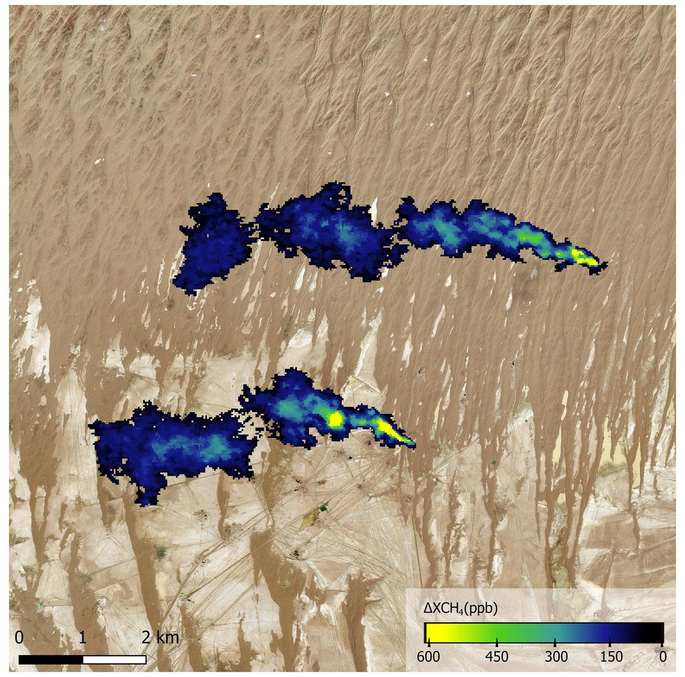
Spaceborne imaging spectrometers such as EnMAP provide the best means of monitoring these methane emissions on a global scale and over a wide area. The potential of the German environmental mission to map these methane plumes has already been confirmed by initial measurements made during the commissioning phase. On 6 October 2022, oil and gas production basins in the south of Turkmenistan were surveyed by EnMAP. Scientists from the Research Institute of Water and Environmental Engineering (IIAMA) of the Universitat Politècnica de València have discovered several active methane point sources in this region using derived EnMAP maps showing the increase in methane concentrations. NASA has also observed these methane flares in Turkmenistan with its Earth Surface Mineral Dust Source Investigation (EMIT) instrument.
Image: 2/4, Credit:
EnMAP Commissioning Phase data 2022 DLR/IIAMA Universitat Politècnica de València
Monitoring water quality in Lake Constance from space
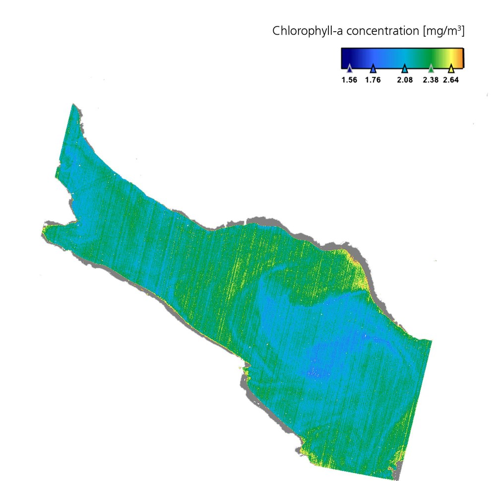
Lake Constance is the largest drinking water reservoir in Europe and provides water for millions of people. But the lake reached a low point due to a long drought characteristic of the modern age of climate change. On 9 August 2022, a very low water level of only 3.05 metres was registered in Constance – only four centimetres above the seasonal record. The consequence is that shallower the water, the faster it warms up. As a result, sediments were washed up to the water surface in some places and green algae carpets formed on a vast scale. To get an overview of the excessive algae growth, EnMAP took a close look at Lake Constance and its chlorophyll-a concentration from space on 1 August 2022, during its commissioning phase. The data on this important plant pigment, evaluated by the Alfred Wegener Institute (AWI), provide information on photosynthesis and thus on algae growth.
On 2 November 2022, the German environmental mission EnMAP completed its test phase and entered routine operations. The mission is managed by the German Space Agency at DLR in Bonn on behalf of the German Federal Ministry for Economic Affairs and Climate Action.
Users can now access the constantly growing EnMAP data archive and submit observation requests. The EnMAP mission data are free of charge.
The hyperspectral data offer new insights into a wide variety of application areas.
Since its launch seven months ago, the German Environmental Mapping and Analysis Program (EnMAP) satellite has been busy collecting data. It has recorded more than 11.4 million square kilometres of Earth's surface – an area larger than Europe – from an altitude of approximately 650 kilometres, using its 242 spectral channels. But these data were not collected for scientific purposes. They were needed to set up the Hyperspectral Imager (HSI) instrument for scientific operation optimally and to check the quality of the acquired data.
„During what is known as the commissioning phase, EnMAP has delivered first-class images of our planet in outstanding quality,“ says Walther Pelzer, DLR Executive Board member and head of the German Space Agency at DLR, which is leading the EnMAP mission on behalf of the German Federal Ministry for Economic Affairs and Climate Action (BMWK). „We are pleased to have successfully completed this test phase in October and are now entering routine operations. We can already look forward with great anticipation to what new, exciting scientific insights for the protection of our planet that we will gain from EnMAP data in the coming decades. One area that the EnMAP data will benefit is the sustainable improvement of agricultural yields that will ensure food security for a growing world population.“
During commissioning, the various components of the EnMAP satellite, including the HSI instrument, had to undergo various tests. During this delicate phase, the German Space Operations Center (GSOC) in Oberpfaffenhofen contributed to the successful completion of commissioning with its many years of experience and will continue to be available for routine operations and – if necessary – provide around-the-clock support to ensure the safety of the satellite. The EnMAP data are received by DLR's German Remote Sensing Data Center (DFD) and Remote Sensing Technology Institute in Oberpfaffenhofen, which also calibrated the images during the commissioning phase, optimised them for the features of the instrument in orbit and, together with the GeoForschungszentrum Potsdam (GFZ), worked to continuously improve the data quality. The data that the satellite sends to Earth cannot be used directly. Only when they are further processed – calibrated, assigned positional data and corrected for atmospheric influences – can users draw quantitative and qualitative conclusions from the products.
From now on, researchers worldwide can submit their requests to DLR. Archived data can be accessed immediately free of charge. A consortium led by the German Space Agency at DLR and GFZ will review the observation requests, which can include the areas of climate change impact, land cover change and surface processes, biodiversity and ecosystem, access to water and water quality, natural resources and disaster management. EnMAP will also provide important data on demand for the 'International Charter Space and Major Disasters' to provide immediate emergency support in the event of a disaster to support relief efforts worldwide. The German Space Agency at DLR places particular importance on the long-term monitoring of environmental change. Consequently, this area of research was given priority during the selection process of future observations beginning at the start of the mission's routine operations phase.
Towards more sustainable agriculture
Agriculture plays an important role in our society for food provision, as well as for the supply of building materials and energy. EnMAP is opening up new possibilities for precision agriculture and agricultural monitoring. The data it gathers are of high spectral resolution and contain important information about the condition and health of crops. On 28 July 2022, during its commissioning phase, EnMAP acquired an image of the northern area of Munich. Using efficient algorithms and modern machine-learning techniques, researchers from the Department of Geography at Ludwig-Maximilians-Universität München (LMU) were able to quantify and map biophysical and biochemical plant properties over large areas for the first time. The growing world population and the simultaneous impact of agriculture on the environment, for example concerning the emission of greenhouse gases, are driving the demand for agricultural production. Against this backdrop, these new data could be used in agricultural management systems to improve resource efficiency and support the sustainability of the required yield optimisation.
Tracking down 'tell-tale' methane plumes with EnMAP
Fossil fuel production – primarily oil and gas extraction and coal mining – is responsible for a large share of anthropogenic methane emissions. They often appear as ‘methane plumes’ emitted by point sources. These relatively small surface elements release relatively large amounts of gas, leaving a tell-tale trail in the atmosphere. If this trace is detected quickly, the cause can be removed quickly, thereby significantly reducing the concentration of greenhouse gases in the atmosphere. Spaceborne imaging spectrometers such as EnMAP provide the best means of monitoring these methane emissions on a global scale and over a wide area. The potential of the German environmental mission to map these methane plumes has already been confirmed by initial measurements made during the commissioning phase. On 6 October 2022, oil and gas production basins in the south of Turkmenistan were surveyed by EnMAP. Scientists from the Research Institute of Water and Environmental Engineering (IIAMA) of the Universitat Politècnica de València have discovered several active methane point sources in this region using derived EnMAP maps showing the increase in methane concentrations.
Insights into the geology of the world's largest erosion crater
Israel's Negev desert is home to the world's largest crater formed by natural erosion – Makhtesh Ramon. Over the last 220 million years, softer rocks such as sandstone have eroded away from areas of harder types such as limestone and dolomite, washing them away and creating a unique crater. This national park, which is one of the driest areas on our planet, is a reservoir for fossils, primeval volcanic cones, magma fissures and chambers and fossilised coral reefs, but above all a tremendous variety of minerals, which are deposited there in the rock. Researchers are particularly interested in the geological units including sandstone, iron-oxide-rich rocks, gypsum, limestone, dolomite, clay minerals such as the phyllosilicate kaolinite, and plutonic crystalline rock units. The sandstone and the plutonic crystalline rock units that have 'migrated' to the surface are visible to the naked eye. But what is hidden underneath? How much rock and minerals are stored in the rock? And how are these units distributed? EnMAP helped researchers from the Remote Sensing Laboratory at Tel-Aviv University get to the bottom of these questions.
The data from the satellite's commissioning phase, which was processed and provided by the DLR ground segment and processed together with the GFZ, gives a good foretaste of the high quality of the data we can expect during the operational phase. The researchers were able to distinguish very precisely between different rock types, such as dolomite and limestone, and minerals, such as clays and sulphates, as well as variations within mineral types within a strip of 40 by 7 kilometres. This offered a better picture of the quantity and distribution of mapped units compared to data acquired from the air and the ground. This knowledge would not have been possible without hyperspectral EnMAP images from space.
Monitoring water quality in Lake Constance from space
Lake Constance is the largest drinking water reservoir in Europe and provides water for millions of people. But in July and August 2022, the lake reached a low point due to a long drought characteristic of the modern age of climate change. On 9 August 2022, a very low water level of only 3.05 metres was registered in Constance – only four centimetres above the seasonal record. The consequence is that shallower the water, the faster it warms up. As a result, sediments were washed up to the water surface in some places and green algae carpets formed on a vast scale.
These carpets grow particularly quickly where there are many nutrients, and the water warms up a lot. To get an overview of the excessive algae growth, EnMAP took a close look at Lake Constance and its chlorophyll-a concentration from space on 1 August 2022, during its commissioning phase. The data on this important plant pigment, evaluated by the Alfred Wegener Institute (AWI), provide information on photosynthesis and thus on algae growth. The data sets on the distribution and productivity of various phytoplankton groups acquired using the satellite are extremely valuable for monitoring the quality of inland waters and their use as a source of water and food, as well as a recreational area.
EnMAP – the German environmental mission and its partners
The EnMAP mission is being managed by the German Space Agency at the German Aerospace Center (Deutsches Zentrum für Luft- und Raumfahrt; DLR) in Bonn on behalf of the Federal Ministry for Economic Affairs and Climate Action (Bundesministerium für Wirtschaft und Klimaschutz; BMWK). OHB System AG was contracted to develop and build the satellite and the hyperspectral instruments. The GeoForschungszentrum Potsdam (GeoForschungsZentrum; GFZ) in Potsdam is the science Principal Investigator for the mission.
Three DLR institutes and facilities have been commissioned for the construction and operation of the ground segment. The German Space Operations Center in Oberpfaffenhofen will conduct and monitor satellite operations, while the German Remote Sensing Data Center and the DLR Remote Sensing Technology Institute will archive, process and validate the received satellite data and make them available to the scientific community. Companies and public authorities will also test the data and use them to prepare future services. The use of EnMAP hyperspectral data by universities and scientific institutions and the development of special applications will be supported by BMWK funding programmes.
