COP27: Earth observation and climate modelling as important tools for monitoring and predicting climate change
November 15, 2022
COP27: Earth observation and climate modelling as important tools for monitoring and predicting climate change
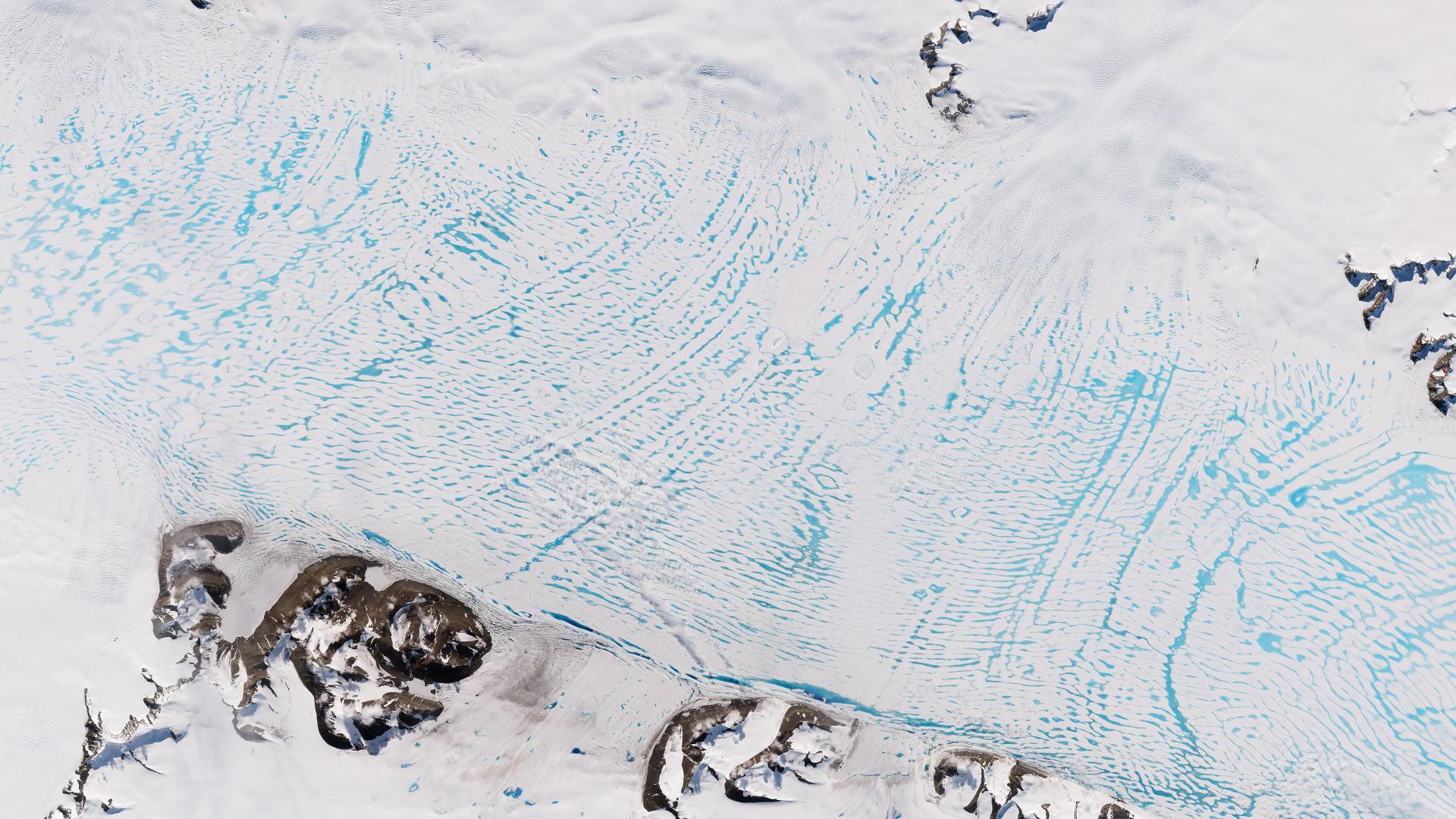
George VI Ice Shelf
This image shows the George VI Ice Shelf. The image was recorded on 23 January 2021 by the Copernicus Sentinel-2 satellite. Previously, using Sentinel-1 data, researchers were able to detect for the first time significant changes in the flow dynamics of the Antarctic ice sheet.
Image: 1/3, Credit:
contains modified Copernicus Sentinel data (2022), processed by ESA, CC BY-SA 3.0 IGO
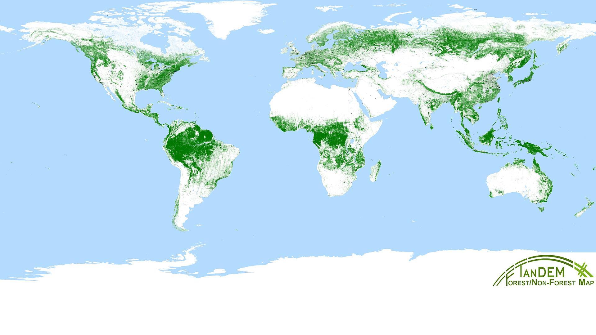
Around one third of Earth's landmass is covered by forests. DLR has created an exceptional data set: the global TanDEM-X forest map. The map was created using interferometric data recorded for the global altitude model of the German TanDEM-X satellite survey, and algorithms from the field of artificial intelligence were developed for global data processing. These were then optimised for different forest types on the basis of tree height, density and structure. The result is a map that shows the extent of forested areas at a resolution of 50 metres.
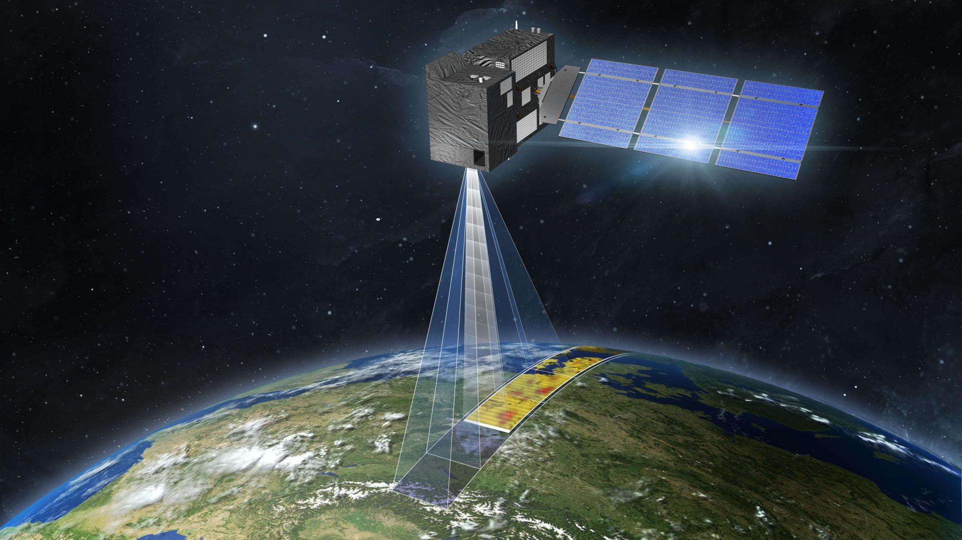
CO2M satellite of the European Copernicus Programme
Representation of the Copernicus Carbon Dioxide Monitoring (CO2M) mission of the European Copernicus programme. For the first time, it will measure specifically how much carbon dioxide is released into the atmosphere by human activities.
The 27th Conference of the Parties of the UNFCCC (COP27) is taking place in Sharm-El-Sheik, Egypt, from 6 to 18 November 2022.
At the opening ceremony of the World Leaders Summit at COP27, DLR researcher Veronika Eyring made a powerful appeal for action, as the recent effects of climate change are unprecedented.
Her work is instrumental in improving climate models and their validation using Earth observation data.
Earth observation satellites can be the right tool to verify compliance with climate targets and the effectiveness of the measures taken.
The primary objective of this year's World Climate Conference COP27 in Sharm-El-Sheik (Egypt) is to ensure the full implementation of the Paris Agreement, because time is running out. In her speech at the opening ceremony of the COP27 World Leaders Summit, Veronika Eyring voiced what most people in the room were probably thinking: “Recent climate change effects are unprecedented. We all know and feel that.” The concentration of greenhouse gases in the atmosphere is reaching new record levels every year. As a result, global warming was already 1.1 degrees Celsius above pre-industrial levels in 2020.
The researcher from the German Aerospace Center (Deutsches Zentrum für Luft- und Raumfahrt; DLR) and the University of Bremen urgently appealed to the audience: “The scientific evidence is clear. But we are not on course! Any further delay in taking collective global action to adapt to climate change and mitigate its impacts means that we miss the short and rapidly closing window of opportunity to secure a liveable and sustainable future for all.”
Improving climate models
Predictions of annual mean temperature change (degrees Celsius) relative to 1850-1900 for five different scenarios depending on the level of climate change mitigation.
Predictions of annual mean temperature change (degrees Celsius) relative to 1850-1900, calculated by the IPCC AR6 Working Group I for five different scenarios by the end of the 21st century, using different climate models and scaled to the global average surface temperature. (Data processed using the ESMValTool, https://www.esmvaltool.org, Visualisation by DKRZ, Scaling from IPCC AR6 WGI Summary for Policymaker, Image SPM8.a).
Atmospheric research and climate modelling, including the development and application of artificial intelligence methods, are among Veronika Eyring's main research areas. Her work and that of her team contributes significantly to the improvement of climate models and their validation using Earth observation data. The results of their research provide a basis for decision-making in international climate policy. She contributed to the Intergovernmental Panel on Climate Change (IPCC) Sixth Assessment Report of Working Group I as coordinating lead author of Chapter 3: The Human Impact on the Climate System, and is co-author on the Summary for Policymakers (SPM) of the same report.
The systematic integration of Earth observation data and Earth system models is considered an important basis for improving climate projections. “At DLR, we are perfectly equipped to develop these applications. We have the necessary data from space and the infrastructure with which to carry out the analyses,” explains Markus Rapp, Director of the Institute of Atmospheric Physics. Earth observation, especially satellite observations from space, provide us with the knowledge we need to understand the Earth system and to help predict future changes in our climate.
Monitoring climate targets
Satellite data can also be the right tool for monitoring compliance with climate targets and the effectiveness of the measures taken. For example, satellites provide important information on the state of global ice masses such as the Greenland Ice Sheet, the increase of greenhouse gases in the atmosphere, sea level rise and changes in vegetation. They also collect data on global deforestation and can thus help map the damage to forest ecosystems.
“Earth observation not only helps in the scientific assessment of the IPCC's Assessment Report and in determining the state of the climate, but it has now reached the stage where operational systems can take on an increasingly important role in the verification of the Paris Agreement in the future. An example is the Copernicus CO2 Monitoring Verification System (CO2MVS), a system with two satellites that will be able to derive carbon dioxide emissions globally from 2026 onwards,” explains Albrecht von Bargen, contact person for satellite-based climate observation at the German Space Agency at DLR and spokesperson for the Climate Working Group of the space agencies at COP27.
A global problem needs a global perspective: Earth observation satellites have been delivering reliable data on the state of our planet for many years, thereby providing the scientific basis in the fight against climate change.
Using Earth observation satellites to combat climate change (ice masses & glaciers)
Your consent to the storage of data ('cookies') is required for the playback of this video on Youtube.com. You can view and change your current data storage settings at any time under privacy.
Using Earth observation satellites to combat climate change (ice masses & glaciers)
A global problem needs a global perspective: Earth observation satellites have been delivering reliable data on the state of our planet for many years, thereby providing the scientific basis in the fight against climate change.
Credit:
German Space Agency at DLR
A global problem needs a global perspective
During the Earth Information Day, held as part of the World Climate Conference, the new revision of the Global Climate Observing System (GCOS) Implementation Plan was presented and recommended for adoption. The GCOS Implementation Plan integrates the results of the World Climate Report, the GCOS Status Report and scientific studies on climate cycles. In addition, this plan contains recommendations for a global climate observation system that covers the entire Earth system – from the atmosphere to the oceans, from the cryosphere to the biosphere – and that includes the water, energy and carbon cycles. Similarly, representatives from different organisations and institutions, including space agencies, advocated for Earth observation to be more firmly secured as a legitimate means of verifying climate targets, especially in the monitoring, verification and reporting (MVR) of the goals set in the Paris Agreement.
Currently, for example, the DLR satellites TerraSAR-X and TanDEM-X provide a highly accurate, three-dimensional image of Earth, contributing to the further development of land surface parameters. In the future, the EnMAP satellite, launched on 1 April 2022, will contribute to the precise characterisation of methane sources in combination with Sentinel-5P measurements. The future Franco-German LIDAR mission MERLIN will focus on measuring global methane content, day and night. It will be able to detect a variety of methane sources, even those emitting methane over large areas but at low concentrations, such as thawing permafrost soils.
Results from the German-American GRACE mission and its successor GRACE-FO have been echoed in the IPCC's scientific reports for years. A unique feature of this mission is its capability to measure the Arctic and Antarctic ice masses and how they are changing, which makes it possible to estimate the melting of the polar ice cap. In order to maintain the continuity of these important measurements, DLR is working together with the German Research Centre for Geosciences (GFZ) and NASA on a follow-up mission from 2028. Adding in ESA’s Next-Generation Gravity Mission (NGGM) mission at a later date, further hydrological aspects with high climate relevance are to be highlighted with improved precision.
The DLR Institutes of Atmospheric Physics and Optical Sensor Systems are working on the small satellite mission CO2Image, whose imaging spectrometer will allow an extraordinarily high spatial resolution for trace gas measurements. The satellite will therefore act like a magnifying glass for the Copernicus CO2M satellites, for example, by measuring the emissions of small and medium-sized power plants and industrial facilities, thus complementing global measurements.
Significant German participation in satellite-based Earth observation
Germany is a leading participant in the Earth observation programmes of the European Commission, the European Space Agency (ESA) and the European Organisation for the Exploitation of Meteorological Satellites (EUMETSAT). The German Space Agency at DLR designs the programmes in accordance with the objectives of the Federal Government. The national satellite missions complement the European activities. DLR institutes are active on all levels in Earth observation, including satellite and airborne observations; together they perform research on global change with a wide variety of missions. DLR develops archiving and processing technologies, as well as algorithms for deriving relevant parameters from Earth observation data, and analyses the results. The German Space Agency at DLR promotes further developments at universities and research institutions.


