From the shape of impact craters, conclusions can be drawn about the geological and climatic processes during the development of a surface. The older a crater, the more eroded its rim protruding above the plain. The degree and type of filling provides information about volcanic or glacial processes. The Mare Serpentis region in the southern Martian highlands is an example of the different processes that have altered the landscape there.
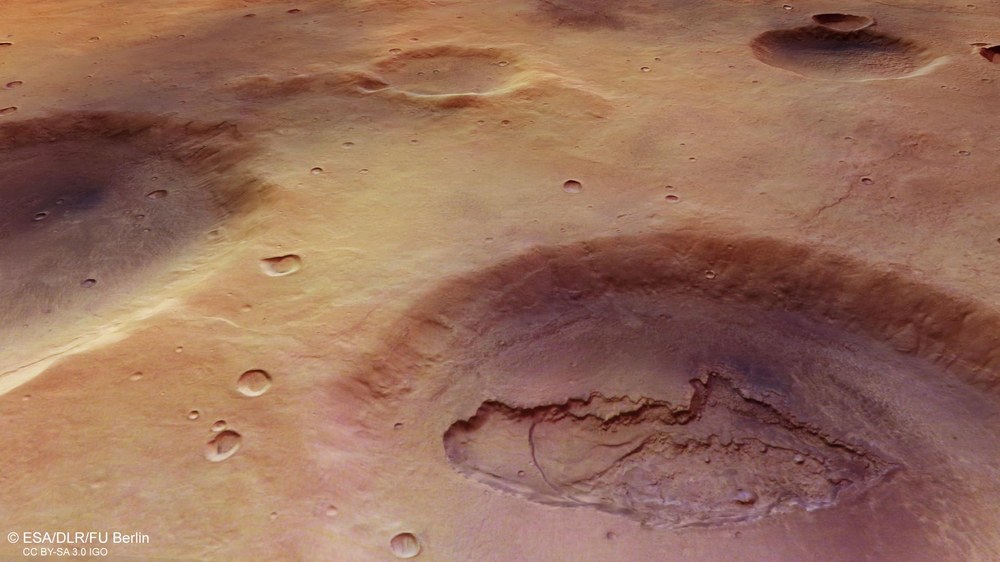
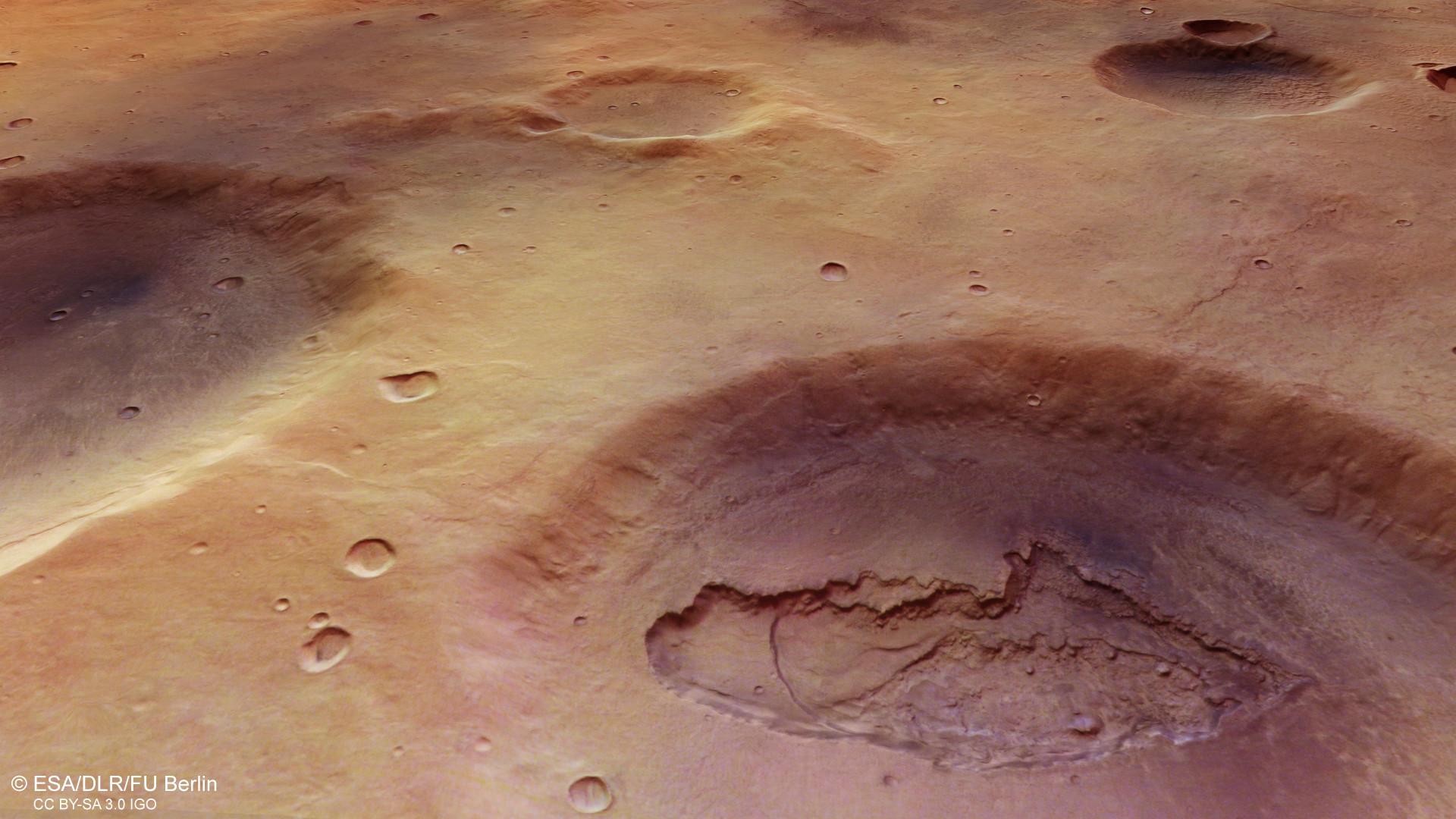
In the southern Martian highlands, numerous impact craters bear witness to the planet's geological and climatic past. In the Mare Serpentis region, the 'Sea of Serpents', different processes have left their traces. Here, a 35-kilometre impact crater provides interesting insights into the subsurface ('collapse feature' in image 3). Here, a pit that is about 20 kilometres long, nine kilometres wide and several hundred metres deep opens up, exposing different alternating layers in the subsurface. Some appear to consist of angular rock fragments in a fine-grained groundmass. The curved shape of a prominent terrain step inside the pit suggests that it was formed by the subsidence of the layers into a cavity below.
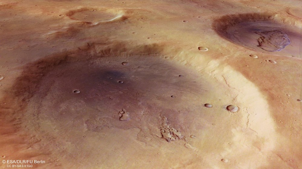
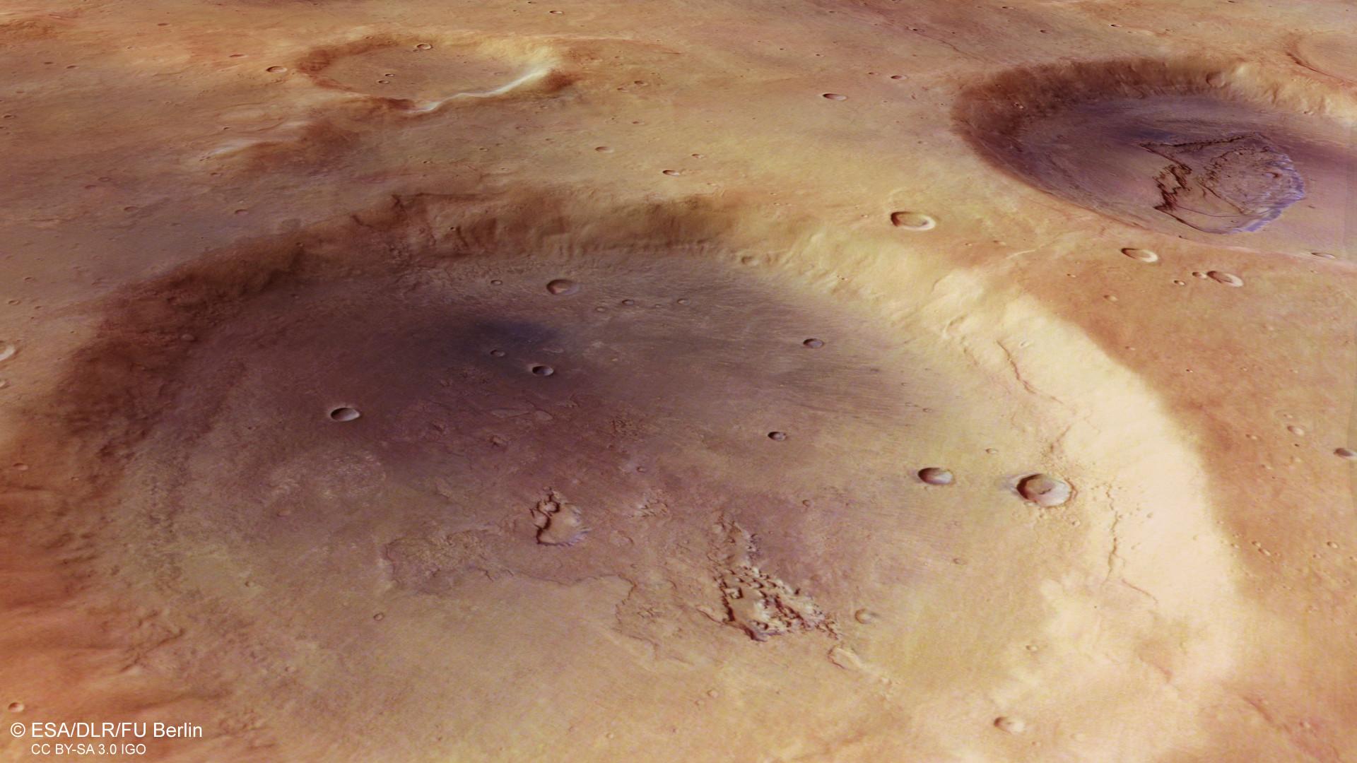
The heavily eroded rim of this 45-kilometre crater suggests a very old age of possibly more than three billion years. Its flat floor has some interesting traces of erosion and a striking dark shade that is bluish in these contrast-enhanced images, but would appear greyish-black in reality. It is dark, wind-transported sand that probably originates just below the crater floor and comes from deposited layers of old volcanic ash. These 'ash layers' were cut by impacts of asteroids. The fine-grained material was released and carried away by the wind.
Traces of volcanism, tectonics, ice and water in the ancient highland region of Mare Serpentis on Mars, which is riddled with craters.
DLR's High Resolution Stereo Camera (HRSC) has been in operation for almost 19 years and will soon have completed 24,000 orbits around Mars.
Focus: Exploration, planetary research, Mars
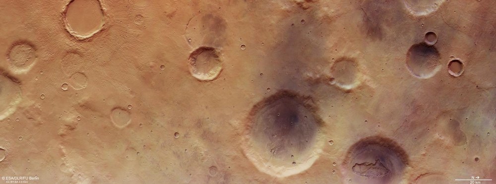
The countless impact craters on other celestial bodies provide planetary researchers with valuable insights: They are 'windows' into the Red Planet's geological past, which spans four-and-a-half billion years. Image data from the High Resolution Stereo Camera (HRSC) on board ESA's Mars Express spacecraft show the Mare Serpentis, region on Mars, which lies northwest of the huge Hellas Planitia impact basin. This crater is 2300 kilometres and more than eight kilometres deep. The HRSC was developed by the German Aerospace Center ( Deutsches Zentrum für Luft- und Raumfahrt; DLR) and has been sending images of our planetary neighbour to Earth since January 2004.
The Mare Serpentis region (Latin for 'sea of serpents') was named after the constellation Serpens near the celestial equator. The landscape presented here covers an area of 270 kilometres by 100 kilometres and is therefore almost as large as the German state of Brandenburg. Impact craters of different ages randomly distributed on the surface can be seem here. The younger craters in the image have more pronounced, contoured rims. In contrast, the rims and the interior of the older craters are much more eroded and almost levelled.
The flat-floored, 22-kilometre-diameter crater in the top left of the plan view (southwest) is surrounded by a distinct ejecta layer with many grooves extending radially away from the crater rim. Compared to the other large craters, it appears to be a younger impact crater because of the much more sharply defined crater rim. Some of the material ejected during the impact landed in three smaller, older craters in the immediate vicinity.
In addition, the crater has a so-called concentric crater fill (image 3). This is a common feature in the Martian mid latitudes (30 to 60 degrees north and south of the equator) and describes a relatively uniform, partially layered fill with a somewhat concentric pattern. It is formed when debris-covered glaciers move slowly along the crater wall and converge near the centre of the crater floor. The water ice in these glaciers was detected with radar data acquired by the US SHARAD instrument on board the Mars Reconnaissance Orbiter. The upper layer of debris and dust prevents the ice from evaporating as a result of solar radiation.
The smaller craters on the right (northern) edge of the image also show an ice-rich crater fill – not concentric, but lobate (image 3). The prominent rims again indicate that the craters are younger.
Small valleys and remnants of impact craters
In the lower left part of image 3, a number of small valleys can be seen leading into an old impact crater that has been almost completely erased by erosion. These valleys are witness to a long-gone era of flowing water on the surface of Mars. Mineralogical studies have confirmed that the only liquid that once flowed through these valleys was water. At the top centre of the image, a strongly eroded impact crater also shows several small, winding valleys leading into what remains of the crater. Below it is a crater with a diameter of approximately 18 kilometres, which has clearly visible alcoves and channels in the crater wall (image 3). The floor is also covered by a sinuous, presumably ice-rich filling, but apparently in an earlier stage.
The largest impact crater in the image has a diameter of 45 kilometres ('dark eroded impact crater' in image 3). Its size and heavily eroded rim indicate a very old age, and its flat floor exhibits irregular pits and a striking dark colour. Interestingly, all the craters on the right side of the image are characterised by this dark colour, presumably created by grey-black sands transported by the wind. In the contrast-enhanced images, the sand appears bluish. This material is thought to have originated directly beneath the craters from deposited layers of old volcanic ash. These ash layers were exposed by the large impact craters, releasing the fine-grained material and allowing it to be blown by the wind.
Faults in a formerly volcanically active region
In the lower right part of the image, another 35-kilometre impact crater provides interesting insights into the subsurface ('collapse feature' in image 3). Here, a pit that is about 20 kilometres long, nine kilometres wide and several hundred metres deep opens up, exposing different alternating layers in the subsurface. Some appear to consist of angular rock fragments in a fine-grained groundmass. The curved shape of a prominent terrain step inside the pit suggests that it was formed by the subsidence of the layers into a cavity below. This type of collapse is known to occur in volcanically active regions where ancient lava tubes or magma chambers emptied, creating cavities in the subsurface into which the overlying rock layers later collapsed. The region in and around Mare Serpentis was known to be volcanically active in the past.
Image processing
The images were acquired by the HRSC (High Resolution Stereo Camera) on 1 May 2022 during Mars Express Orbits 23,157. The ground resolution is approximately 21 metres per pixel and the image is centred at about 44 degrees East and 30 degrees South. The colour image was created using data from the nadir channel, the field of view which is aligned perpendicular to the surface of Mars, and the colour channels of the HRSC. The oblique perspective view was generated from the digital terrain model, the nadir and colour channels of HRSC. The anaglyph image, which creates a three-dimensional impression of the landscape when viewed with red/blue or red/green glasses, was derived from the nadir channel and one stereo channel. The colour-coded topographical view is based on a digital terrain model (DTM) of the region, from which the topography of the landscape can be derived. The reference body for the HRSC-DTM is a Mars equipotential surface (Areoid). The systematic processing of the camera data was carried out at the DLR Institute of Planetary Research. Personnel in the Department of Planetary Sciences and Remote Sensing at the Freie Universität Berlin used these data to create the image products shown here.
The High Resolution Stereo Camera (HRSC) was developed at the German Aerospace Center (DLR) and built in cooperation with industrial partners (EADS Astrium, Lewicki Microelectronic GmbH and Jena-Optronik GmbH). The science team, led by Principal Investigator (PI) Dr Thomas Roatsch of the DLR Institute of Planetary Research, consists of 52 co-investigators from 34 institutions and 11 nations. The camera is operated by the DLR Institute of Planetary Research in Berlin-Adlershof.
