Better coordination of emergency services in buildings
December 6, 2023 | Tracking system makes people and surrounding structures visible
Better coordination of emergency services in buildings
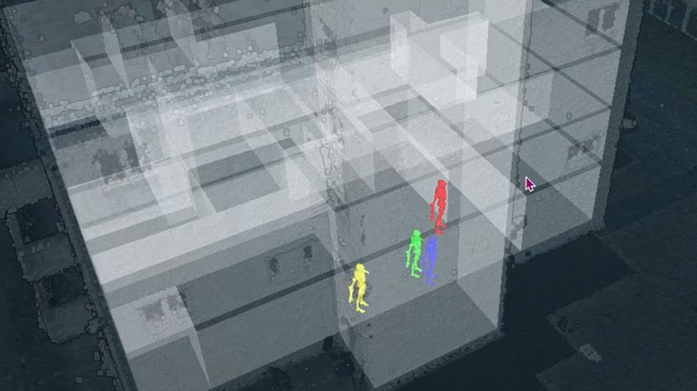
Emergency services in a building
Emergency responders were recognised via a tracking system in various tests. The ComInA project combines DLR technologies for tracking and mapping. The aim is to achieve efficient coordination of people.
The ComInA project combines DLR technologies for tracking and mapping for emergency services.
Successful tests have been completed in various scenarios.
Follow-up projects aim to transfer the technology into practical applications.
Focus: Security, disaster relief, technology transfer
Emergency responders operating in buildings or industrial plants should not only know their exact location. In order for a mission to be coordinated, it is also important that the location of each individual team member can be tracked. In a project, the German Aerospace Center (Deutsches Zentrum für Luft- und Raumfahrt; DLR) has now identified alternatives in cases where standard methods such as satellite navigation or mobile communications are not available. This is important in places such as tunnels, mines, complex building structures or in disaster scenarios.
The aim of the ComInA (Computer Assisted Intra-Objective Reconnaissance) project is to support the strategic approach of emergency services with a tracking system. "Within DLR's security research, we are working closely with authorities and organisations as well as with industry. ComInA builds on technologies that DLR has developed in previous projects, which have now been adapted to meet specific requirements. Not only is it possible to precisely locate people, but 3D mapping material is also created to support the coordination of operations," emphasises Anke Kaysser-Pyzalla, Chair of the DLR Executive Board. "The exchange of knowledge and technology transfer is a key element of security research. Only by implementing technologies can we make a contribution to ensuring security."
Sensors can be attached to shoes or clothing
leitet.
"The goal of localisation is to coordinate people efficiently. At the same time, the emergency services can immediately determine whether those involved have fully inspected a building or rough terrain," explains Susanna Kaiser from the DLR Institute of Communications and Navigation in Oberpfaffenhofen. Tracking is carried out using a small mobile device that the people carry with them. The device transmits the location and movement data of all those involved to the operations centre. They have an overview of what is happening via a laptop or tablet and can make informed decisions.
The technologies developed by DLR include, for example, inertial sensors that are attached to shoes or clothing. Inertial sensors record acceleration and rotation rate data, which can be used to determine movement and activities. An integrated minicomputer estimates the positions of the emergency responders in real time, which are then refined using a further process in the operations centre. Additional optical navigation and mapping systems provide images of the surroundings inside and outside buildings. "All systems communicate and complement each other. This was also successfully demonstrated with ComInA. Tests with emergency services in various environments were very promising," says Ralf Berger from the DLR Institute of Optical Sensor Systems in Berlin, which is leading the project alongside the Institute of Communications and Navigation.
3D mapping material supports operational coordination
In addition to the localisation of people, 3D mapping material is also created. For example, the operations centre can assess whether a building has been fully inspected. This image was created during a test and shows a DLR building.
In the follow-up project that has just been launched, researchers are now further developing the concept. In doing so, they are closely focussing on the needs of future users. There are plans to introduce the concept to the market at the end of the project. The ComInA project is being carried out in cooperation with the Ministry of Internal Affairs of North Rhine-Westphalia and a police authority.
Civil security research
Civil security research at DLR focuses on the research and development of solutions and technologies that ensure the protection of citizens and critical infrastructure from damage caused by natural disasters and major emergencies, terrorist threats and organised crime.
These solutions help increase the security of citizens and thus their quality of life and strengthen the civil security industry. This is characterised by a scenario- and capability-oriented approach. Realistic scenarios and required capabilities form the basis for the development of practice-oriented solutions together with end users and companies across different specialisations and disciplines, taking social aspects into account.