Afternoon whirlwinds – the dynamic plains of Mars's Arcadia Planitia
June 26, 2025 | Mars Express mission
Afternoon whirlwinds – the dynamic plains of Mars's Arcadia Planitia
Volcanic dust and wind lanes in Arcadia Planitia
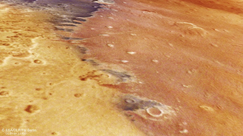
The northern hemisphere of Mars is dominated by a vast lowland plain that shows significantly fewer geological landscape features than the highlands of the southern hemisphere. Evidence of long-lasting winds is widespread in these regions. This image offers a perspective view of a prominent rock ridge in the Arcadia Planitia region. This structure acts as a barrier to the prevailing winds, where dark sands of volcanic origin have been deposited and transported by the wind. On closer inspection, streamlined ridges – known as yardangs – can be seen on the plain in the right half of the image, which form parallel to the prevailing wind direction.
Arcadia Planitia (the 'Arcadian Plain') lies in the mid-northern latitudes of Mars. The landscape is strongly characterised by winds sweeping across the northern lowlands. Dark volcanic material has been deposited on the ridge of the terrain, which acts as an obstacle to the wind. The reddish regions are covered by countless sculpted ridges, known as yardangs, which have been carved into the rock by dust carried in the wind. On the lower right, an impact crater approximately 15 kilometres across is visible; when it formed, volatile substances in the subsurface – possibly ice – were mobilised, mixed with the ejected material and created a lobe-shaped ejecta blanket.
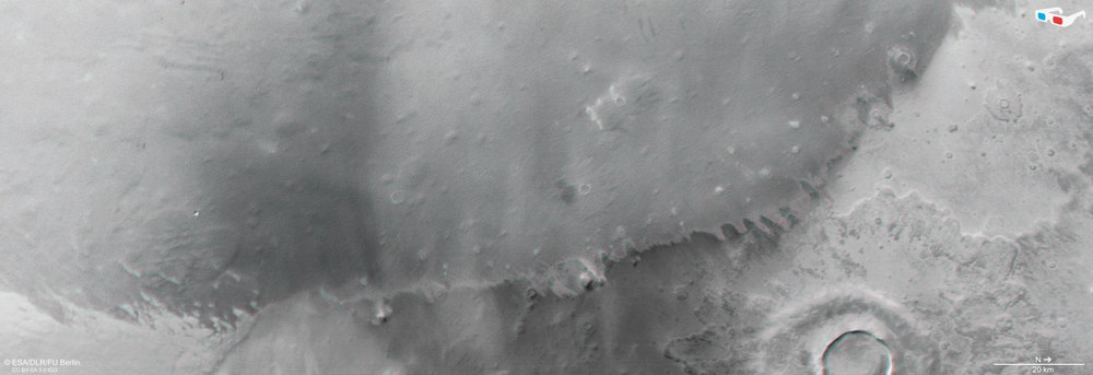
Anaglyph images can be generated from the nadir channel of the DLR-operated HRSC camera onboard ESA's Mars Express probe – which is directed vertically onto the surface of Mars – combined with one of the four oblique stereo channels. When using red-blue or red-green glasses, they render the landscape in three dimensions and convey an idea of it in relief. This allows both large-scale and subtle topographical details to be determined and examined in a spatial context.
New images from the German High Resolution Stereo Camera aboard the Mars Express space probe show dust-laden whirlwinds on the Arcadia Planitia plain.
These phenomena play an important role in the formation of wind-sculpted rock ridges, called yardangs.
On Mars, such dust devils can reach speeds of 45 metres per second and heights of eight kilometres.
Focus: Space, space research, exploration, Mars
Seemingly endless expanses, wind-sculpted rock formations and subsurface ice: the Arcadia Planitia region of Mars has a rich variety of landscape features. This is confirmed by new image data from the High Resolution Stereo Camera (HRSC) on board the European Space Agency's (ESA's) Mars Express mission. The HRSC was developed by the German Aerospace Center (Deutsches Zentrum für Luft- und Raumfahrt; DLR).
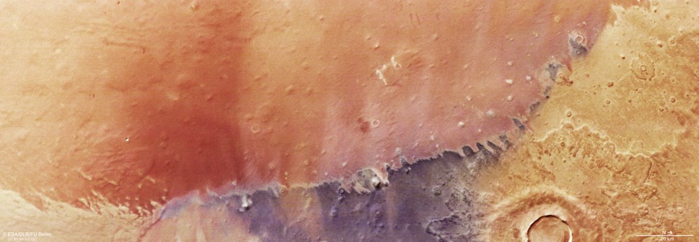
Arcadia Planitia, a plain in the Martian lowlands, was flown over during orbit 26,333. The plain borders the northwestern flank of the Tharsis plateau – home to the striking 'shield volcanoes' of the Tharsis Montes, including Olympus Mons, the largest volcano in the Solar System. The plain is largely covered by lava flows from the Amazonian epoch, which began 1.8 billion years ago and continues today. Arcadia Planitia (the 'Arcadian Plain') is named after a fictional hilly landscape described in ancient Greek literature.
'Dust devils' over the lowlands
Mars has an extremely thin atmosphere – approximately 100 times thinner than Earth's. It consists of 95 percent carbon dioxide, four percent nitrogen, some argon and trace gases. Nevertheless, atmospheric phenomena familiar on Earth are frequently observed on Mars.
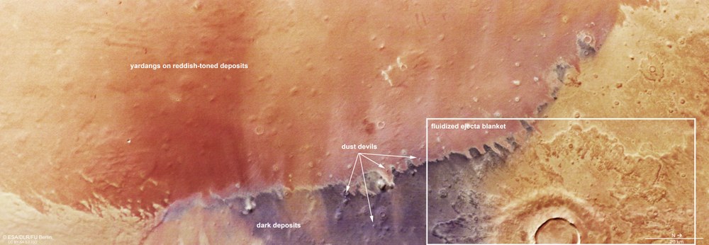
Four dust-laden whirlwinds, known as dust devils, can be seen in this snapshot from the HRSC on Mars Express. These short-lived, localised events typically occur in the afternoon when the Sun heats the Martian surface, warming air near the ground and causing it to rise and generate local dynamics. This results in a vertical vortex carrying dust and sand into the atmosphere. This phenomenon plays a major role in spreading dust across the Martian surface.
In the HRSC images, dust devils appear as small bright spots with a greyish shadow (see annotated image). The slight pinkish colour gradient at each spot is caused by the rapid movement of the whirlwind during image acquisition: the nine HRSC image channels capture the same area at slightly different moments – the nadir channel looks vertically straight down, while other channels look slightly forward or backward. The movement of the spacecraft during its orbit allows the same landscape to be captured by one sensor after another, with a slight time lag.
Landforms in Arcadia Planitia
Wind continues to shape the lowland region of Arcadia Planitia today. One terrain ridge acts as an obstacle for dust-laden winds, which deposit dark, volcanic sand there ('dark deposits'). The extensive reddish areas consist of countless yardangs; to see them, you must zoom in to the image's resolution limit of 18 metres per pixel. The view is particularly remarkable because it captures several 'dust devils'. At the lower right is a 15-kilometre crater whose ejecta blanket indicates volatile-rich components in the subsurface that have liquefied the ejecta (a 'fluidised ejecta blanket').
Because the dust devil is also moving, it is in a slightly different location at each recorded moment on an image channel. Overlaying the channels, as in this image, creates a slight colour fringing effect. This offset allows for changes in the dust devils' locations to be tracked and their direction and speed to be determined.
On Mars, these whirlwinds can reach speeds of up to 45 metres per second and heights of up to eight kilometres. They are typically less than 100 metres wide and are often observed over wide plains such as Arcadia Planitia – just as they occur on dusty desert landscapes on Earth. Despite the very different atmospheric conditions, there are many similarities between Martian and terrestrial dust devils. On Mars, however, they are often much bigger – mainly due to large temperature fluctuations on the Red Planet caused by intense warming during the day.
A wind-sculpted surface
At first glance, the image appears slightly blurred. Zooming in, however, reveals that the surface in the reddish-coloured region is covered by countless wind-sculpted rock ridges – explaining the initial impression (see annotated image). These rock formations, or 'yardangs', form when persistent winds, mostly blowing in the same direction, selectively erode softer rock or compacted sediment with the dust they carry. The harder rock remains and is sculpted into these ridges.
The boundary between the yardang-rich reddish terrain and the adjacent darker region is clearly visible – there are no yardangs in the darker area. The first scientific mention of yardangs occurred in the early 20th century, in connection with the Lop Nor desert in northwest China. The term comes from the Uyghur word 'yar', meaning a steep sand embankment.
The absence of such features on the darker ground could indicate differences in surface material, rock hardness or wind intensity. Wind erosion is one of the most vigorous geological processes on Mars, especially in low-lying plains like Arcadia Planitia, where the wind continually remodels the landscape. These yardangs are close to the resolution limit of the image – just under 20 metres across. A tiny, relatively young crater is also depicted in razor-sharp detail.
A striking feature in the HRSC images is the 'ejecta blanket' from an impact crater approximately 15 kilometres wide (see annotated image). The lobed shape of this ejecta and its double-layered structure are typical of a high quantity of volatile components in the impact region. Scientists refer to this as 'fluidised ejecta', and the entire crater as a 'rampart crater'.
The shape and dimensions of the ejecta – recorded by spectrometers in narrow wavelength bands of visible and near-infrared light – reveal signatures of water-rich material, possibly ejected from shallow depths and deposited around the crater. The crater rim is not worn down by wind, indicating that the impact event occurred relatively recently in geological terms.
Good chances of water ice
Ejecta with a high proportion of volatile components – including, above all, water – are relatively common in the mid-latitudes of Mars. They support the theory that during periods when Mars' rotation axis was highly inclined, ice accumulated down to mid-latitudes. It was likely later buried by other material and so protected from sublimation – the direct transition of ice into water vapour.
The location of Arcadia Planitia in the mid-latitudes of Mars makes it likely that ice exists in the subsurface of this plain. It may be present in the form of ice either inside or outside of the pores of the soil material. In the former case, 'pore ice' fills only the naturally existing pore space. In the latter case, the amount of ice exceeds the existing pore volume in the soil and 'takes up' the space it requires.
Due to the probable presence of water ice in the soil, some researchers have proposed Arcadia Planitia as a landing site for future robotic or even human missions to Mars. In the case of a crewed mission, the ice could be used to produce drinking water – provided it could be thoroughly purified and treated – or split into hydrogen and oxygen for use as rocket fuel.
Image processing
The images were captured by the High Resolution Stereo Camera (HRSC) on 10 November 2024 during Mars Express Orbit 26,333. The ground resolution is approximately 18 metres per pixel and the image is centred at roughly 21 degrees east and 41 degrees north. The colour image was created from data acquired by the nadir channel – with a field of view oriented perpendicular to the Martian surface – and the colour channels of the HRSC. The oblique perspective view was generated from a digital terrain model, the nadir channel and the colour channels of the HRSC. The anaglyph image, which conveys a three-dimensional impression of the landscape when viewed with red-blue or red-green glasses, was derived from the nadir channel and one stereo channel. The colour-coded topographic view is based on a digital terrain model (DTM) of the region, from which the topography of the landscape can be derived.
Map server
To download the released raw images and DTMs of the region in GIS-compatible formats, follow this link to the map server
The High Resolution Stereo Camera was developed at the German Aerospace Center (DLR) and built in cooperation with industrial partners (EADS Astrium, Lewicki Microelectronic GmbH and Jena-Optronik GmbH). The science team, led by Principal Investigator (PI) Daniela Tirsch, consists of 50 co-investigators from 35 institutions across 11 nations. The camera is operated by the DLR Institute of Space Research (formerly DLR Institute of Planetary Research) in Berlin-Adlershof.
