June 20, 2026 | Prepared for emergencies – exercise in the Ahr Valley
Future technologies for civil protection
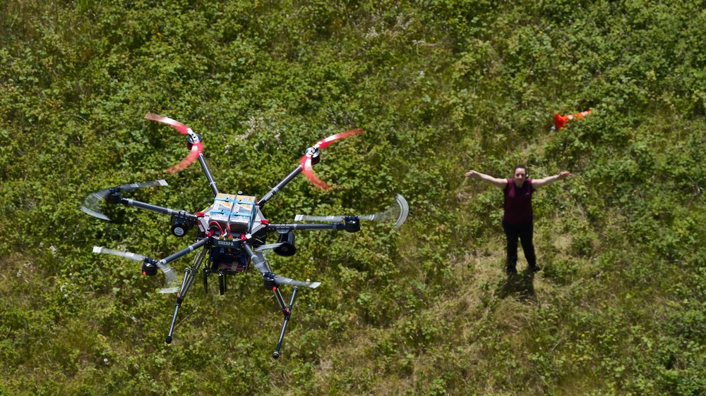
DLR drone finds people in distress – shown here in the exercise scenario
Remote-controlled and autonomous drones, such as this one from the DLR Institute of Flight Systems, assist in the RESITEK project's exercise scenario in the Ahr Valley by searching for missing persons and carrying out aerial reconnaissance of the situation.
Image: 1/9, Credit:
DLR / Leon Jakobs
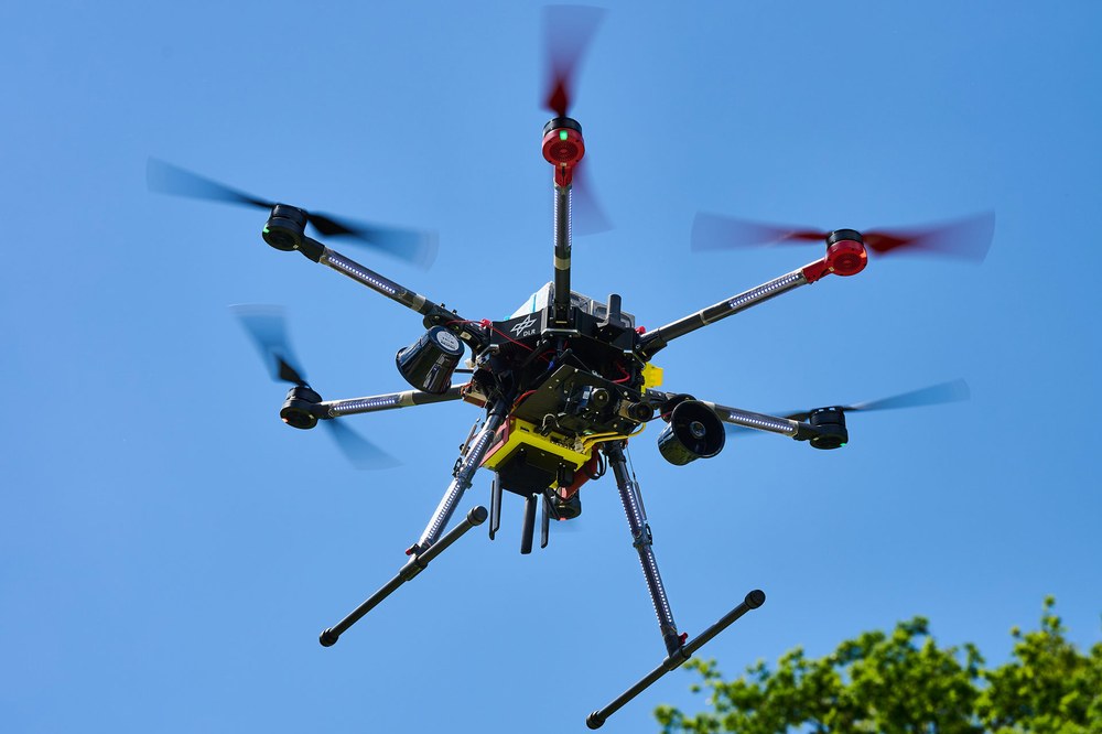
DLR drone in the skies above the Ahr Valley
The RESITEK exercise in the Ahrweiler district, Rhineland-Palatinate, based on a realistic disaster relief scenario, is designed to test and demonstrate new technologies, as well as their interaction with emergency responders.
Image: 2/9, Credit:
DLR / Leon Jakobs
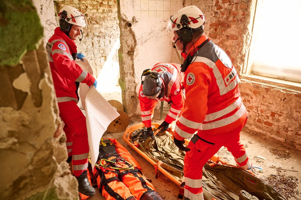
Rescuing a person after reconnaissance by robotic systems
Part of the scenario: while surveying a destroyed building, DLR's robotic systems discovered an injured person. The alerted rescue teams subsequently recover this person.
Image: 9/9, Credit:
DLR / Leon Jakobs
As part of the RESITEK project, 16 DLR institutes are pooling their expertise to support authorities and organisations with security-related responsibilities using innovative technologies in the event of a disaster.
Satellites, drones, vehicles and robotic systems deliver information rapidly, enabling precise situational assessment.
All data collected is consolidated into a situational picture and made available to emergency response teams.
Extreme rainfall, rising water levels, flooding – people need to be rescued and critical infrastructure secured within the shortest possible time. How can this be achieved when energy, communications and transport systems are also affected by the disaster? Who then coordinates the emergency responders and provides a situational overview? Sixteen institutes from the German Aerospace Center (Deutsches Zentrum für Luft- und Raumfahrt; DLR) have now demonstrated how new technologies can strengthen and improve civil protection processes. In collaboration with public authorities and organisations with security responsibilities, DLR has carried out a technical exercise based on a realistic scenario in the Ahrweiler district of Rhineland-Palatinate. The exercise focused on demonstrating new technologies, the interaction between systems and their benefit to emergency responders.
"Incomplete or delayed situational information, a lack of connectivity and insufficiently networked stakeholders can significantly impair the effectiveness of disaster response operations. Events such as large-scale flooding, storms or power outages highlight society's high dependence on functioning critical infrastructure," says Anke Kaysser-Pyzalla, Chair of the DLR Executive Board. "RESITEK demonstrates how modern technologies can strengthen civil protection. What matters is not just the performance of individual systems, but also how they work together. All parties involved benefit from the intensive exchange of knowledge that takes place during the exercise."
A flood – what is the situation?
This is the specific scenario for the exercise carried out as part of DLR's RESITEK project (Resiliente Technologien für den Katastrophenschutz, or in English 'Resilient Technologies for Civil Protection'): a flood has reached devastating proportions and several local authorities are requesting help. The communications network has failed, and roads, bridges and buildings have been destroyed. People must be evacuated and provided with emergency support.
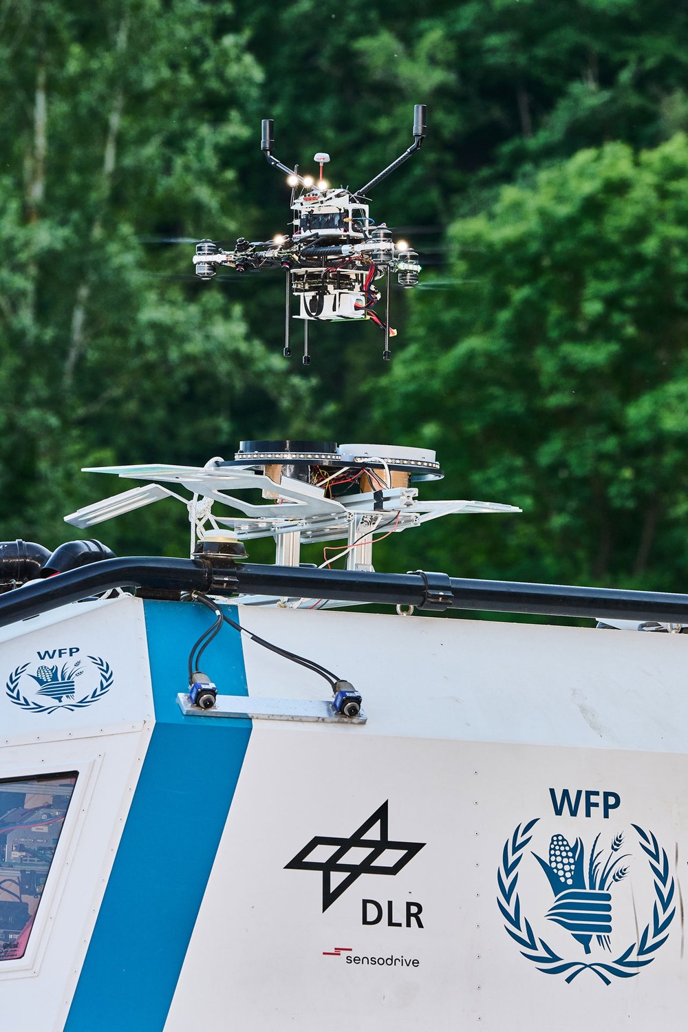
Drone launch from the SHERP
The SHERP vehicle carries the drone from the DLR Institute of Robotics and Mechatronics on its roof into the operational area, where it takes off to survey the situation.
Credit:
DLR / Leon Jakobs
Once the alert is raised, DLR – in this scenario – rapidly assesses the situation across a wide area and supports rescue operations. Using satellite data, drone flights and reconnaissance by robotic systems, a precise picture of the situation ultimately emerges.
In addition, a local communications network is set up, which emergency responders use to exchange information and also receive data from dangerous or hard-to-reach areas. DLR teams conduct coordinated operations together with the Bavarian Red Cross (Bayerisches Rotes Kreuz; BRK) and the German Red Cross (Deutsches Rotes Kreuz; DRK) in Rhineland-Palatinate. Remote-controlled and autonomous drones assist with the search for missing persons and with reconnaissance. One key aspect is the shared airspace situational picture, which allows all drones and helicopters to be coordinated. In the exercise scenario, the researchers are therefore also simulating helicopter operations. Robotic systems also support the reconnaissance mission. These include the ARDEA robotic drone, the Scout rover and the SHERP amphibious vehicle, provided by the World Food Programme (WFP). SHERP is also used for transport and supply tasks.
Collecting, evaluating and meaningfully combining information
All information gathered is transmitted to DLR's operations centre. There, researchers use artificial intelligence to analyse satellite data, aerial imagery, drone footage and rover findings, consolidating them into a single situational picture. This situational picture is then made available to emergency responders digitally via web services or as printed maps. It serves as a central basis for decision-making and operational coordination.
Resilience of critical infrastructure – power grids, mobility and space weather
In parallel, damage scenarios are analysed and models developed to improve the resilience of power grids. Planning optimal routes for emergency operations and evacuations is also a focus. There is also the broader threat posed by space weather, as solar storms can disrupt critical infrastructure. Improved forecasting models help to assess their potential impact on power grids and communications links at an early stage.
The RESITEK project (Resiliente Technologien für den Katastrophenschutz, or in English 'Resilient Technologies for Civil Protection') is led by the DLR Institute of Flight Systems and the DLR Institute of Robotics and Mechatronics. The Center for Satellite-Based Crisis Information (ZKI) at the Earth Observation Center (EOC) is responsible for the technical exercise in the Ahr Valley, together with the DLR Institute of Robotics and Mechatronics. The main participants in the RESITEK project exercise, alongside the DLR institutes, are the Bavarian Red Cross (BRK), the German Red Cross (DRK) – Rhineland-Palatinate Regional Association and its local branches, as well as representatives of the Ahrweiler district. The IQIB (Institut für qualifizierende Innovationsforschung und -beratung, or 'Institute for Qualifying Innovation Research and Consulting'), a DLR subsidiary based in the Ahrweiler district, is also supporting the exercise. A further exercise based on a storm scenario is planned for autumn in Braunschweig.