Thyles Rupes – the 'legendary land' in the south of Mars
September 16, 2026 | Mars Express mission
Thyles Rupes – the 'legendary land' in the south of Mars
Thyles Rupes on Mars
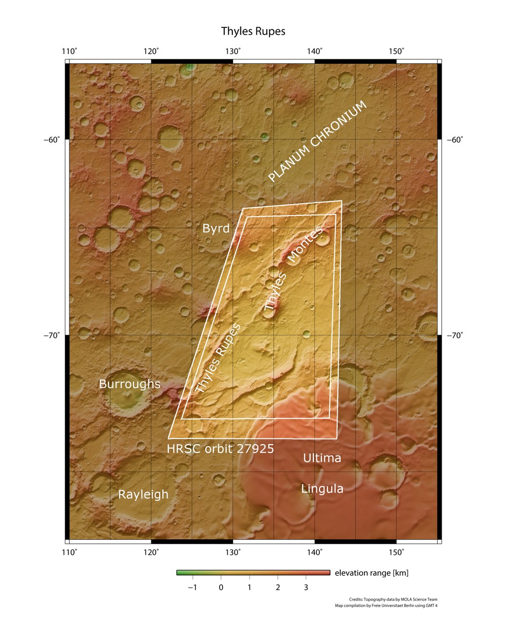
This top-down view shows the area in the south polar region of the Red Planet, characterised by striking escarpments (steep slopes) and frozen dunes. 'Thyles' refers to the fictional land of Thule from a Greek legend. 'Rupes' means 'cliff' or 'steep slope'.
The HRSC images shown above come from the inner area outlined in white. Here, there are both escarpments ('Thyles Rupes') and mountains ('Thyles Montes'). The area is located in the south polar region of Mars, very close to the polar cap. The tongue-shaped ridge Ultima Lingula (bottom of the image) represents a spur of the southern ice cap. The elevation figures below the image ('elevation range') are given in kilometres.
Image: 2/5, Credit:
NASA/JPL/USGS/MOLA; FU Berlin
3D (anaglyph) image of Thyles Rupes on Mars
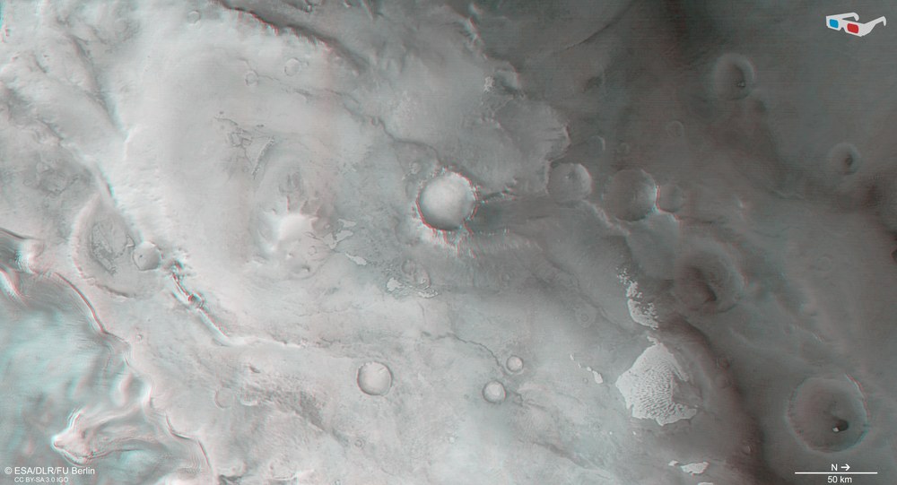
'Anaglyph' images can be generated from the HRSC camera's nadir channel – which points vertically to the Martian surface – and one of its oblique-viewing stereo channels. When viewed with red-blue or red-green glasses, they give a three-dimensional impression of the landscape. The high image resolution of 17 metres per pixel allows even the smallest topographic features to be visualised. Shown here is Thyles Rupes in the south polar region of Mars.
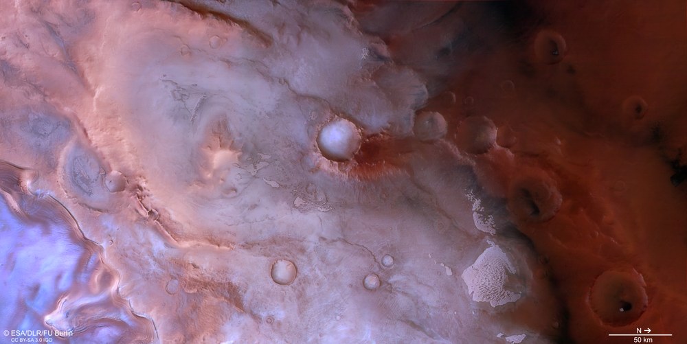
New images captured by the German HRSC stereo camera show the striking steep slopes of Thyles Rupes near Mars's south pole.
The images document tectonic processes, some of which took place billions of years ago.
Since 2004, the HRSC has been sending high-resolution image data of Mars back to Earth, from which digital terrain models are generated.
Focus: Spaceflight, exploration, Mars
Escarpments (steep slopes) kilometres wide with an eventful history – new image data from the High Resolution Stereo Camera (HRSC) on board the European Mars Express mission show part of 'Thyles Rupes'. This is a group of elongated ridges in the polar latitudes of the southern hemisphere. The HRSC is a camera experiment run by the German Aerospace Center (Deutsches Zentrum für Luft- und Raumfahrt; DLR).
The name 'Thyles' derives from the land of Thule in ancient Greek legend, described as a distant place beyond the boundaries of the known world. The Italian astronomer Giovanni Schiaparelli first used this term in the late 19th century. 'Rupes', the second part of the name, is of Latin origin and means 'cliff' or 'escarpment'. Mars has numerous rupes formations. They document tectonic processes, some of which took place billions of years ago. Unlike Earth, Mars has no active plate tectonics, where the movement of continental plates triggers earthquakes. The Martian crust consists of a single, continuous plate, so tectonic processes here arise from different causes.
Characteristic features of Thyles Rupes on Mars
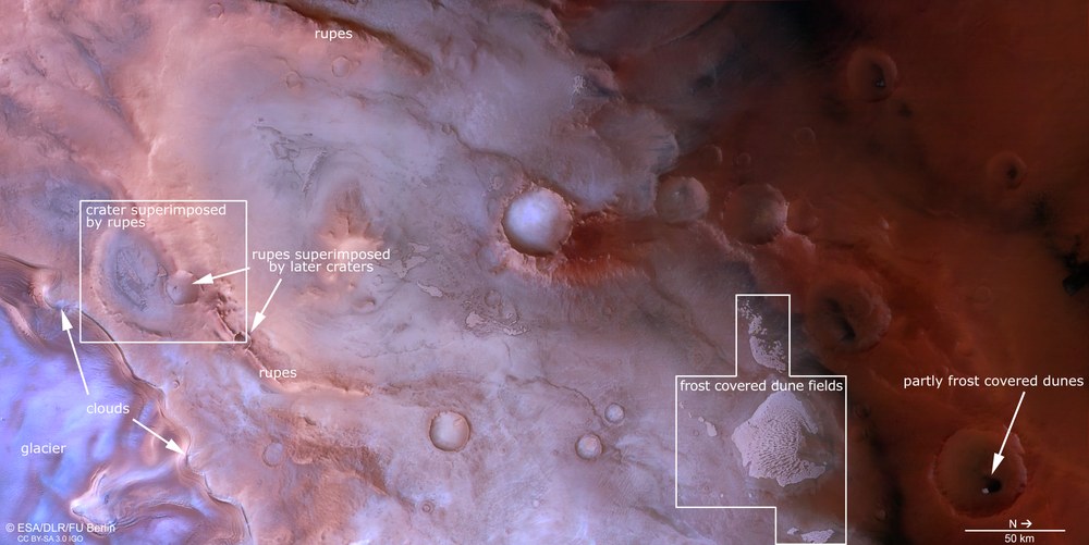
This region is criss-crossed by escarpments. These were formed by tectonic activity as the Red Planet contracted in its early history. Some escarpments formed on top of pre-existing impact craters ('crater superimposed by rupes'). Others had already formed by the time they were struck by asteroids ('rupes superimposed by later craters'). In the bottom left corner of the image is an enormous glacier, which is in fact part of the south polar cap and likewise has a high escarpment. Large temperature differences here in spring often give rise to clouds, as can also be seen in this image. In the bottom right of the image, extensive frost-covered dune fields can be seen ('frost covered dune fields' or 'partly frost covered dunes'). North is to the right of the image, south to the left.
Shortly after Mars formed, its interior cooled over a long period, causing the entire planet to lose volume. As a result, its crust wrinkled like shrivelling skin, as there was now less surface to cover. Thyles Rupes therefore formed through deformation and faulting, in which one block of the Martian crust was pushed upwards relative to another. Enormous cliffs formed as a result.
The Thyles escarpments extend over hundreds of kilometres and cut through heavily cratered terrain here in the south polar region. This makes them easy to identify in HRSC images, and it is clear that the escarpment walls either cover impact craters or have themselves been struck by impacts. Researchers can use this to determine the relative age of the craters and of the faulting event that created Thyles Rupes. Craters beneath the escarpment are older, craters on top of it are younger – with the tectonic processes taking place in between.
Dunes of volcanic sand
In some areas, dune fields made of dark volcanic material can be seen. Even during the Martian spring – the time when the images were taken – they were covered with carbon dioxide (CO₂) frost. The dark sand originates from nearby escarpments or crater walls, from where it gradually trickles down onto the Martian surface. Winds then transport and deposit the sand, forming longitudinal dunes, transverse dunes and barchanoid ridges – a type of fused crescent dune. The mixture of different dune types indicates that the winds have blown from different directions.
DLR's High Resolution Stereo Camera (HRSC) is on board the European Mars Express mission and has been sending data on the Martian surface and atmosphere back to Earth for more than 20 years. The image data is used to generate colour images and digital terrain models, which are used to map the Red Planet and represent its surface in three dimensions. This makes it possible to reconstruct geological processes from Mars's early history.
Background info – image processing
The images were captured by HRSC on 17 February 2026 during Mars Express orbit 27,925. The ground resolution is approximately 65 metres per pixel, and the centre of the image is located at approximately 69 degrees South and 137 degrees East. The colour image was created using the nadir channel – whose field of view is oriented perpendicular to the Martian surface – together with the HRSC's colour channels. The oblique perspective view was generated from the digital terrain model together with the HRSC's nadir and colour channels. The anaglyph image, which, when viewed with red-blue or red-green glasses, conveys a three-dimensional impression of the landscape, was derived from the nadir channel and a stereo channel. The colour-coded topographic view is based on a digital terrain model of the region, from which the topography of the landscape can be derived.
The High Resolution Stereo Camera was developed at the German Aerospace Center (DLR) and built with industry involvement (EADS Astrium – now Airbus –, Lewicki Microelectronic and Jena-Optronik). The research team, led by Daniela Tirsch, Principal Investigator (PI), comprises 50 co-investigators from 35 institutions and 11 countries. The camera is operated by the DLR Institute of Space Research (formerly the DLR Institute of Planetary Research) in Berlin-Adlershof.