Weather data from space – DLR and EUMETSAT strengthen collaboration
December 19, 2025
Weather data from space – DLR and EUMETSAT strengthen collaboration
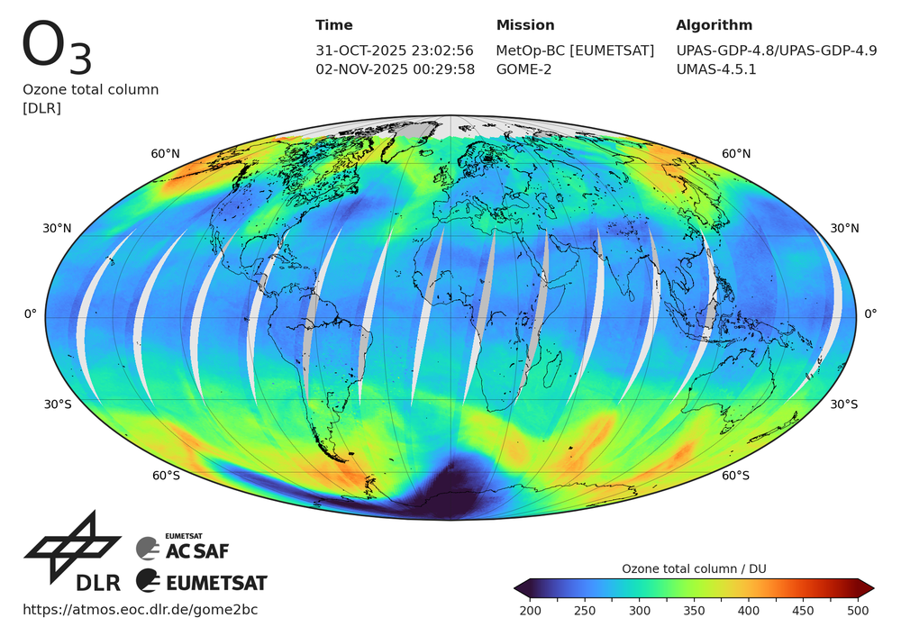
Total column ozone: MetOp-B and MetOp-C weather satellite measurements
This image shows the total column ozone in Dobson units (DU) and is based on combined measurements from the GOME-2 instruments on the European weather satellites MetOp-B and MetOp-C. A region of low ozone concentration (black) is distinctly recognisable above the Antarctic – known as the ozone hole. This phenomenon typically occurs in the autumn and winter months in the southern hemisphere, as confirmed here by measurements from 31 October to 2 November 2025. MetOp-B has been in operation since 2013, and MetOp-C since 2018. The GOME-2 instruments provide continuous, global measurements of trace gases and air pollutants such as ozone, nitrogen dioxide, sulphur dioxide, bromine monoxide and formaldehyde. This image was produced as part of EUMETSAT's Atmospheric Composition Monitoring Satellite Application Facility (ACM SAF) https://atmos.eoc.dlr.de/app/missions/gome2
DLR and EUMETSAT are expanding their more than 20-year partnership and intensifying scientific exchange in Earth observation, atmospheric research and meteorology.
Joint planning of future satellite missions, and the further development of algorithms, calibration and validation, will improve weather forecasting and air-quality monitoring.
The DLR Earth Observation Center provides and optimises trace-gas data products for the MetOp satellite programme and, in future, for Copernicus Sentinel-4 and Sentinel-5, which measure air quality and ozone.
As part of the planned EPS-Aeolus mission from 2034, DLR will contribute its expertise in Doppler lidar wind measurements and support more accurate medium-range weather forecasts.
Focus: Space, Earth observation
The German Aerospace Center (Deutsches Zentrum für Luft- und Raumfahrt; DLR) and the European Organisation for the Exploitation of Meteorological Satellites (EUMETSAT) are expanding their scientific collaboration in the fields of Earth observation, atmospheric research and meteorology. Looking ahead, both organisations are keen to intensify their scientific exchange and work more closely on planning future satellite missions. This collaboration also encompasses joint activities to improve satellite measurements by means of advanced algorithms, calibration and validation. The cooperation agreement was approved at the end of November by the EUMETSAT Council's 30 member states and has also been signed by DLR Executive Board Chair Anke Kaysser-Pyzalla, DLR Divisional Board Member for Space Anke Pagels-Kerp and EUMETSAT Director-General Phil Evans.
Our shared objective is to further improve weather forecasting, monitor air quality with greater precision and, overall, drive ambitious innovations in atmospheric observation from space. Short- and medium-term effects of climate change on humanity and the environment, as well as on industry and the economy, need to be identified early on and their consequences mitigated. In doing so, we are providing public stakeholders with an increasingly robust basis for decision-making.
The newly adopted agreement builds on more than 20 years of successful collaboration, which includes the development of the METimage multispectral camera on the recently launched MetOp Second Generation A1 satellite as well as the expertise of EUMETSAT's dedicated centres of excellence – the Satellite Application Facilities (SAFs). Within this expert network, DLR's Earth Observation Center (EOC) is processing trace gas data captured by the GOME-2 sensor on board the MetOp-A/B/C satellite series. In future, the EOC will also provide trace-gas data products for the Copernicus Sentinel-4 and Sentinel-5 satellite missions, launched during summer 2025. Both satellites are operated by EUMETSAT and will measure air quality and the ozone concentration of our atmosphere over the coming decades. For this, the EOC continues to develop algorithms dedicated to data acquisition and processing.
For climate and weather forecasts, DLR is also investigating emissions and occurrences of greenhouse gases such as carbon dioxide and methane, researching the formation and influence of clouds, and analysing wind profiles. The DLR Institute of Atmospheric Physics is contributing its wide-ranging expertise, particularly with regard to the measuring instrument of the upcoming EPS-Aeolus (European Polar System) Earth observation programme of the European Space Agency (ESA) and EUMETSAT.
Building on ESA's Aeolus Earth Explorer mission (2018–2023), EPS-Aeolus will in future measure wind fields and their global movement at altitudes of up to 40 kilometres. This data will significantly improve medium-range weather forecasts of up to ten days. The EPS-Aeolus satellite mission will measure the speed of wind fields using laser technology, deploying a Doppler lidar (light detection and ranging) instrument. The Institute of Atmospheric Physics was involved early on in the development of the measurement instrument on board Aeolus and is now continuing this work. This strengthened partnership with EUMETSAT is also seeing researchers plan aircraft-based measurements synchronised with the new satellites to verify and calibrate the accuracy of their instruments. The first EPS-Aeolus satellite is scheduled to launch in 2034.
