October 2, 2026 | CoMet 3.0 Tropics measurement campaign over South American wetlands completed
HALO returns from measurement flights in Brazil
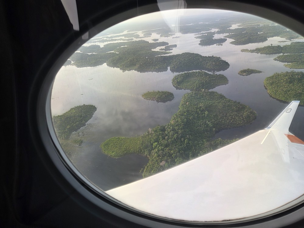
View of the Balbina reservoir from a HALO window
Reservoirs like this one can release the greenhouse gas methane through natural biological decomposition processes. These processes are particularly efficient in warm, shallow tropical waters.
Image: 1/11, Credit:
Gordon Rüdinger
Forest fire in Brazil
The DLR Institute of Atmospheric Physics and Brazil's National Institute for Space Research (Instituto Nacional de Pesquisas Espaciais; INPE) were responsible for the scientific leadership of the CoMet 3.0 Tropics campaign. The Universities of Bremen and Heidelberg, both of which are involved in HALO, and the Max Planck Institute for Biogeochemistry in Jena also took part. The DLR Flight Experiments facility supported the flight campaign. Approximately 120 researchers from institutions in both countries were involved.
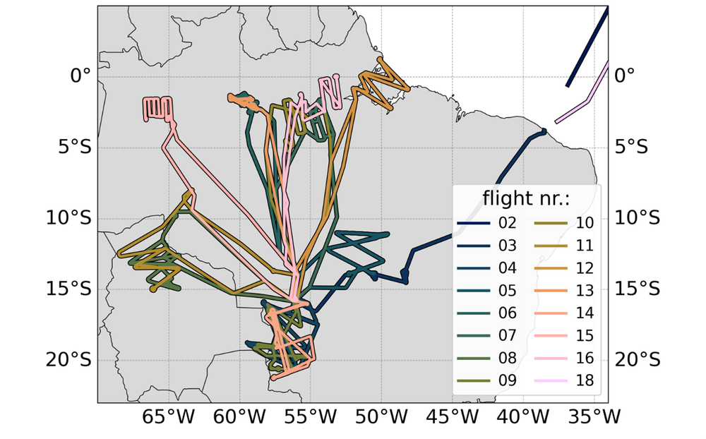
Flight routes of the CoMet 3.0 Tropics measurement campaign
During the CoMet 3.0 Tropics measurement campaign, 14 measurement flights were conducted from the base in Cuiabá, the capital of the state of Mato Grosso, Brazil.
With 18 research flights and approximately 150 flight hours in total, HALO has successfully completed the CoMet 3.0 Tropics field measurement campaign over South American wetlands.
The measurements have produced a unique dataset on greenhouse gases and related variables.
The data provides reference values for validating satellite missions such as MERLIN, CO2M, Sentinel-5, GOSAT-2 and GOSAT-GW.
The results make it possible to distinguish between natural and anthropogenic sources of methane and contribute to the development of a system for monitoring, reporting and verifying greenhouse gas emissions.
From 25 July to 6 September 2026, the unique scientific instruments on board HALO, the High Altitude and Long Range Research Aircraft, operated by the German Aerospace Center (Deutsches Zentrum für Luft- und Raumfahrt; DLR), measured methane (CH4) and carbon dioxide (CO2) over the wetlands of South America. The flights took the aircraft over the Amazon, the Pantanal (Portuguese for 'wetland'), the Cerrado tropical savanna and – for the first time for HALO – the Llanos de Moxos wetlands in Bolivia. In wetlands, the persistent moisture means that hardly any oxygen reaches the soil. The microorganisms living there therefore break down dead plants without oxygen, producing methane as a by-product. This process is particularly efficient at high tropical temperatures. As a result, wetlands are the largest natural source of methane on Earth and represent the greatest uncertainty in the global methane budget.
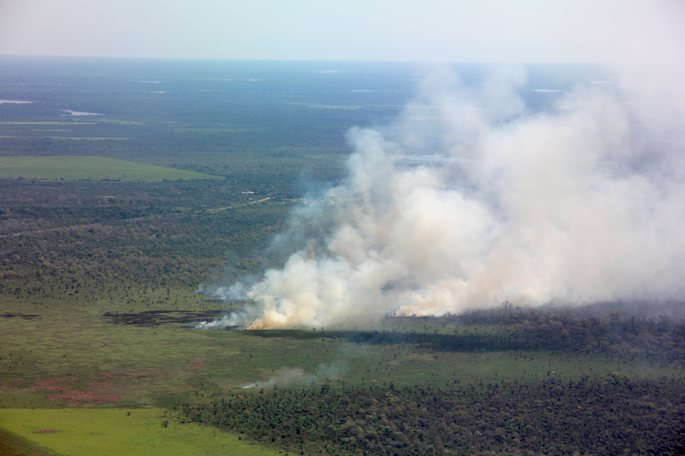
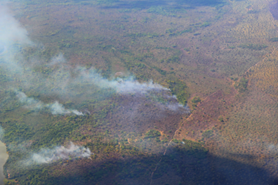
Parts of the Cerrado tropical savanna in flames
During the dry season, large parts of Brazil's Cerrado tropical savanna go up in flames. These fires not only increase greenhouse gas emissions, but also visibly increase the aerosol load over the region.
Credit:
Andreas Fix
The DLR Institute of Atmospheric Physics and Brazil's National Institute for Space Research (Instituto Nacional de Pesquisas Espaciais; INPE) led the campaign scientifically. The Universities of Bremen and Heidelberg, both of which are involved in HALO, and the Max Planck Institute for Biogeochemistry in Jena also took part, while the DLR Flight Experiments facility supported the flight campaign. Approximately 120 researchers from institutions in both countries were involved. In addition to Brazil, Bolivia also granted permission for measurement flights in its airspace.
Three flights over the Pantanal – one of the world's largest inland wetlands, approximately half the size of Germany – recorded how greenhouse gas emissions evolved at the start of the dry season. HALO carried out four flights over Bolivian territory, two of which recorded exceptionally high methane concentrations over the Llanos de Moxos wetlands. HALO also flew over the Balbina reservoir and the 325-metre-high measurement tower of the Amazon Tall Tower Observatory (ATTO). ATTO is part of a German-Brazilian project in the Brazilian rainforest, where meteorological, chemical and biological data, as well as greenhouse gas concentrations, have been measured continuously since 2015.
Further measurement flights covered the Amazon, its estuary and the Mamirauá wetlands. Here too, the instruments recorded surprisingly high methane concentrations in the boundary layer close to the ground. Near Santarém, on the Amazon, lies a measurement site of the European Space Agency (ESA), known as a 'supersite'. HALO flew over the site three times in total.
The measurement programme was rounded off by flights over pristine rainforest and through several smoke plumes from forest fires, which are also a significant source of greenhouse gases in the atmosphere. Altogether, HALO's remote sensing and in situ instruments have produced an invaluable dataset for science.
Reference data for satellite missions and climate models
A key objective of the campaign was to validate existing satellite missions and prepare for future satellite missions to measure greenhouse gases. These include the German-French climate mission MERLIN (Methane Remote Sensing Lidar Mission), the Copernicus Anthropogenic Carbon Dioxide Monitoring (CO2M) mission – one of the Copernicus Sentinel Expansion missions – and Sentinel-5, as well as the Japanese greenhouse gas satellites GOSAT-2 and GOSAT-GW, and others. Airborne measurements provide reference data with high spatial resolution for this purpose, which is particularly valuable in the tropics, where difficult-to-access terrain and dense cloud cover limit ground-based and satellite observations.
At the same time, the campaign helps to distinguish methane emissions from natural sources, such as tropical wetlands, and methane from anthropogenic sources, including agriculture, waste management, energy production and forest fires. In doing so, it reduces the uncertainty of global methane estimates. The data is being analysed using regional inverse models and chemistry-climate models, and the results will contribute to reporting under the United Nations Framework Convention on Climate Change.
For this purpose, HALO carried the unique CoMet payload on board. It included the CHARM-F lidar and the MAMAP2D imaging spectrometer for measuring the greenhouse gases carbon dioxide and methane between the aircraft and the ground. Both serve as airborne demonstrators for future satellite instruments. In situ instruments also measured trace gases and atmospheric concentrations of carbon dioxide, methane, carbon monoxide (CO) and nitrous oxide (N2O). A further remote sensing instrument measured nitrogen dioxide (NO2), nitrous acid (HONO) and formaldehyde (HCHO). HALO's upgraded basic instrumentation and meteorological dropsondes complemented the measurements. Selected flight legs were deliberately routed over ground-based measurement stations such as ATTO and the Santarém supersite, linking the aircraft measurements to long-term time series recorded on the ground.
International collaboration
CoMet 3.0 Tropics is part of the scientific collaboration between Germany and Brazil. The field campaign was led by the DLR Institute of Atmospheric Physics together with the Max Planck Institute for Biogeochemistry in Jena and the University of Bremen, in close cooperation with Brazil's National Institute for Space Research (INPE). Heidelberg University, Ludwig-Maximilians-Universität München (LMU Munich) and numerous Brazilian institutions contributed additional expertise and measurement data. These included the Instituto de Pesquisas Energéticas e Nucleares (IPEN), the Universidade Federal de Mato Grosso (UFMT), the Universidade do Estado de Mato Grosso (UNEMAT), the Instituto Nacional de Pesquisas da Amazônia (INPA) and several research institutes of the University of São Paulo (USP). Approximately 120 researchers from Germany and Brazil took part in the campaign.
Other South American participants included the Universidad Mayor de San Andrés (Bolivia) and the Chacaltaya Global Atmosphere Watch (GAW) station. There is also international collaboration with ESA through the ESA-funded BRACCIOLE (Brazilian CO2, CH4 and N2O Large-Scale Experiment) project. BRACCIOLE is part of CoMet 3.0 Tropics and works closely with the complementary ESA CarbonARA project. The project used the measurement flights in combination with ATTO and Santarém ground stations to record nitrous oxide and emissions from forest fires, and to compare the results with data from satellite missions such as Copernicus Sentinel-5P, Sentinel-5 and the Japanese GOSAT missions. HALO also flew over a measurement station in Porto Velho, which is operated by the Royal Belgian Institute for Space Aeronomy and supported by ESA through the CARDS project for campaign activities.
CoMet 3.0 Tropics was funded by DLR, the Max Planck Society and ESA.
The HALO research aircraft (High Altitude and Long Range Research Aircraft) is a joint initiative of German environmental and climate research institutions. The aircraft's procurement was funded by the Federal Ministry of Research, Technology and Space (Bundesministerium für Forschung, Technologie und Raumfahrt; BMFTR), the Helmholtz Association, the Max Planck Society (Max-Planck-Gesellschaft; MPG), the Free State of Bavaria, Forschungszentrum Jülich (FZJ), the Karlsruhe Institute of Technology (KIT) and DLR.
The operation of HALO is funded by the German Research Foundation (Deutsche Forschungsgemeinschaft; DFG), the MPG, DLR, FZJ, KIT and the Leibniz Institute for Tropospheric Research (TROPOS) in Leipzig. DLR is also the owner and operator of the aircraft.