Piled up by wind god Aeolus – dunes in Kaiser Crater on Mars
July 15, 2026 | Mars Express mission
Piled up by wind god Aeolus – dunes in Kaiser Crater on Mars
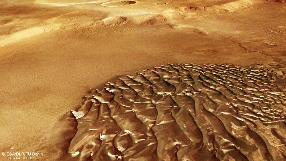
Dark dunes with a metallic sheen in Kaiser Crater on Mars
In the Martian highlands, a large, dark dune field composed of sands of volcanic origin lies in the south of the approximately 200-kilometre-wide Kaiser Crater. The metallic appearance is caused by bright hoarfrost deposits on the dunes' south-facing slopes. This image was taken during the second half of the Martian southern winter. The image width is approximately 20 kilometres.
Martian crater with hoarfrost deposits along its southern rim
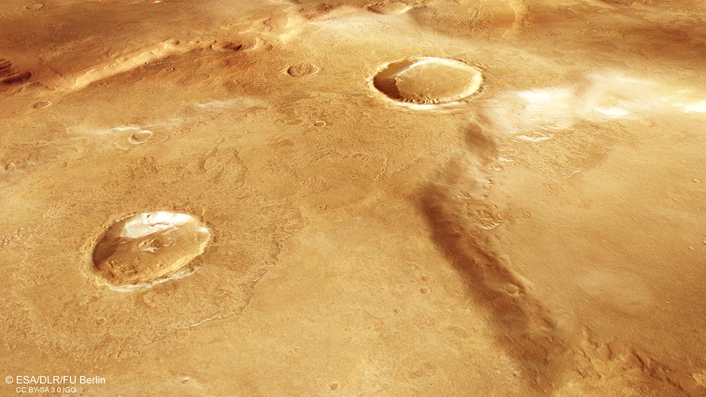
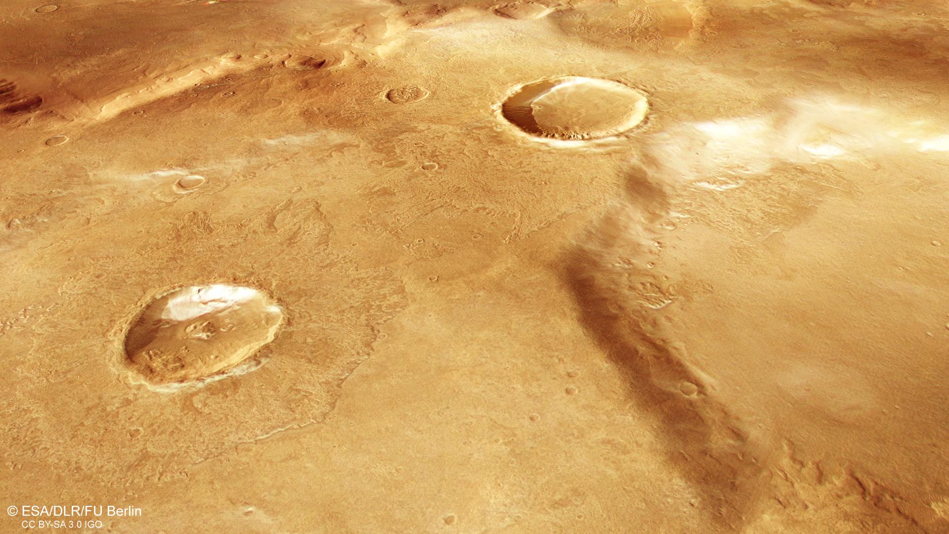
During winter in each hemisphere, the seasonal ice caps at the Martian north and south poles extend to approximately 50 degrees latitude. As this happens, carbon dioxide ice crystals precipitate from the cold atmosphere onto the surface. These deposits persist beyond the winter months and remain into the first weeks of spring. In the crater on the left, such a hoarfrost field can be seen along the inner southern rim.
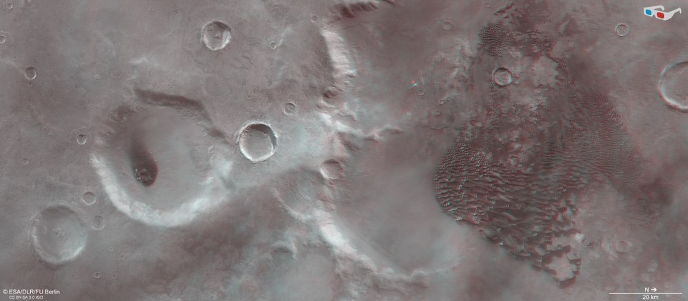
3D (anaglyph) image of the southern part of Mars' Kaiser Crater
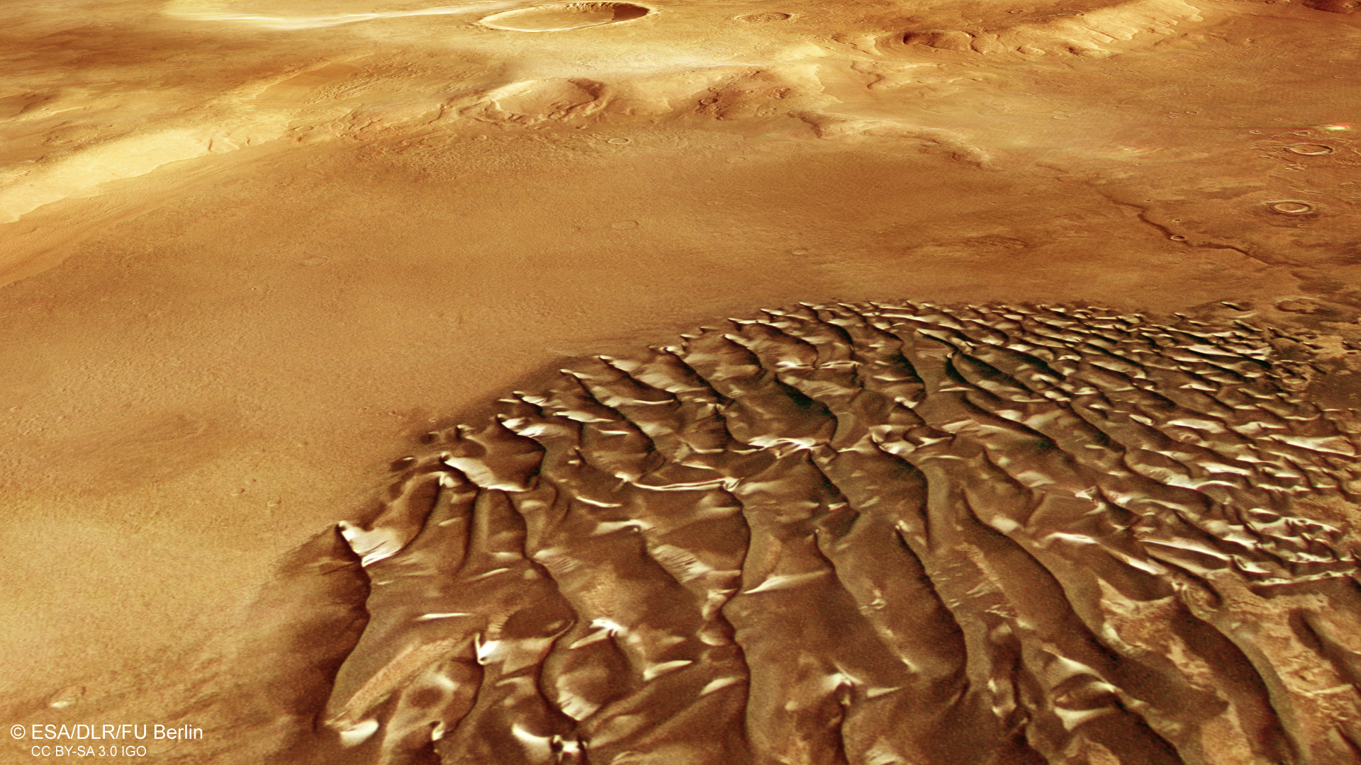
Using the nadir channel, which is directed vertically towards the Martian surface, together with one of the obliquely viewing stereo channels of the HRSC camera, it is possible to generate 'anaglyph' images. When viewed with red-blue or red-green glasses, they provide a three-dimensional view of the landscape. The high image resolution of 17 metres per pixel makes it possible to visualise even the smallest topographic features, such as the transverse and crescent-shaped dunes, some of which are more than 100 metres high.
Images from the German HRSC stereo camera show different types of dunes on the floor of a large impact crater.
Hoarfrost gives the dunes and crater slopes a metallic sheen.
A 'dust devil' kilometres high shows wind in action.
HRSC is a camera experiment developed by DLR and carried aboard the European Mars Express mission.
Since January 2004, HRSC has been reliably transmitting images of Mars back to Earth, from which digital terrain models are generated.
Focus: Spaceflight, exploration, Mars
When you hear the word 'aeolian', you might think of the archipelago north of Sicily, which in ancient mythology was believed to be the home of Aeolus, god of the winds. On our neighbouring planet – just as on Earth – the term refers in this context to wind-driven processes of deposition or erosion. New image data from the German High Resolution Stereo Camera (HRSC) on board the European Mars Express mission shows a large, dark dune field on the floor of the Kaiser Crater, which is over 200 kilometres across, in the southern highlands.
HRSC is a camera experiment developed by the German Aerospace Center (Deutsches Zentrum für Luft- und Raumfahrt; DLR) for ESA's Mars Express mission, and it has been sending images back to Earth since January 2004. Digital terrain models are calculated from the stereo image data, making it possible to map the topography of the Red Planet and visualise its surface in three dimensions. In turn, this enables the reconstruction of geological processes from the early history of Mars in terms of their nature and chronological sequence. On the dynamically changing Earth – whose landscapes are almost all younger than four billion years – such a glimpse into its formative period is not possible.
Crescents merge into fields – dunes in Noachis Terra
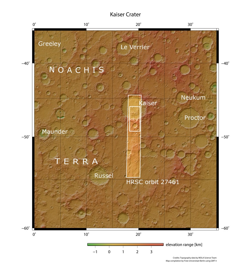
Topographic overview map of Noachis Terra on Mars, showing Kaiser Crater
The highlands of Noachis Terra are among the oldest landscapes on Mars and gave their name to the Noachian Period, which lasted from 4.1 to 3.7 billion years ago. During this time, numerous asteroid impacts created hundreds of large craters, some of which are several hundred kilometres in diameter. Their eroded rims are still visible today. Large volumes of water also flowed across Mars during this period. On 5 October 2025, the HRSC stereo camera on board Mars Express photographed the strip shown here, from which the geological and aeolian phenomena (shown in the small rectangle) are presented.
Credit:
NASA/JPL/USGS/MOLA; FU Berlin
The Kaiser Crater is located in one of the oldest regions on Mars, Noachis Terra, after which the Noachian Period – a geological era dating from approximately 4.1 to 3.7 billion years ago – is named. The great age of the landscape is evident from its surface, which is densely pockmarked with large craters. The image shows the southern part of Kaiser Crater, surrounded by numerous neighbouring craters, including Greeley, Le Verrier and Neukum (see overview map). The latter is named after the German planetary scientist Gerhard Neukum (1944–2014), former Director of the DLR Institute of Planetary Research (now the Institute of Space Research) and the 'father' of the HRSC stereo camera.
Kaiser Crater, named after the Dutch astronomer Frederik Kaiser (1808–1872), is almost two kilometres deep, with a diameter roughly equivalent to the distance between Stuttgart and Munich. The right-hand (northern) side of the image shows its floor. Its southern rim is in the centre of the image, while several smaller impact craters can be seen nearby on the left-hand side.
The dark structures shimmering with a metallic sheen on the crater floor are a vast dune field, with individual dunes composed of dark, volcanic material. The metallic appearance is caused by bright hoarfrost deposits on their south-facing slopes. This image was taken during the second half of the southern winter on Mars, when hoarfrost cover extends from the South Pole to, in some places, the mid-latitudes.
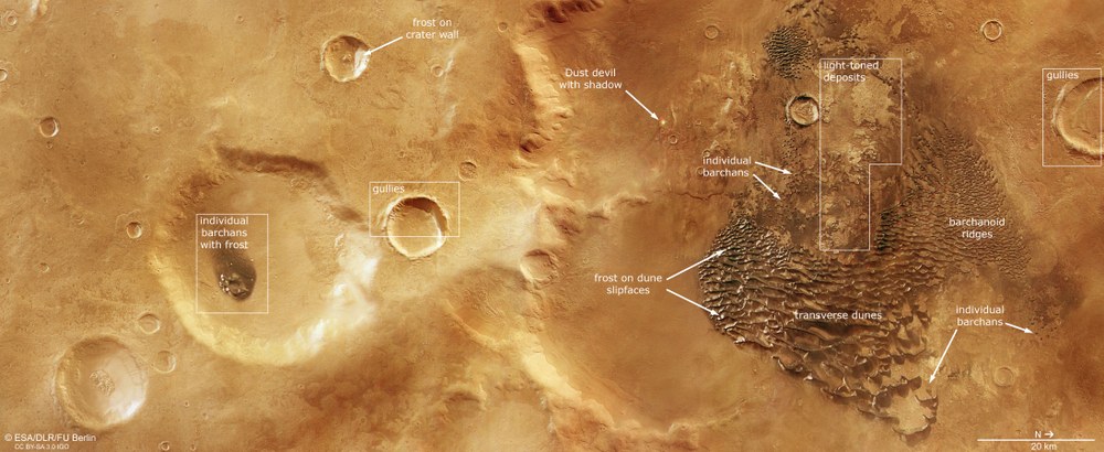
Around Kaiser Crater, various types of dunes can be seen, some of which merge into one another. The individual dunes, mostly at the edge of the field, are classic crescent-shaped dunes, also known as barchans (see annotated image). Whenever more sand is deposited by the wind and consequently becomes ‘available’ for dune formation, individual barchans merge together, forming what are known as barchanoid ridges. These are a transitional form leading to the type that makes up most of the field: transverse dunes. Their crests lie perpendicular to the direction of the wind and, just like those of the barchans, indicate that the wind came from the west.
Geological and aeolian features in the southern part of Kaiser Crater on Mars
This region in the southern Martian highlands is approximately four billion years old. In more recent geological history, wind-driven processes have sculpted the landscape. Crescent-shaped dunes, known as barchans, are widespread. In places, they merge into larger ridges, forming a transitional stage towards larger transverse dunes. Hoarfrost reflects the sunlight, giving the dune fields a metallic sheen ('barchans with frost' in the annotated image). Hoarfrost has also persisted in places on south-facing crater walls ('frost on crater wall'). On some steep crater slopes, channels known as gullies have formed, although their origin remains uncertain. In several locations, wind erosion has removed the surface material, exposing the underlying layers, which appear as bright deposits ('light-toned deposits').
In some places near the dune field, wind erosion has stripped away the surface material, exposing the underlying layers. These appear as bright deposits and indicate the presence of clay minerals. Such minerals typically form through the weathering of the volcanic parent rock, basalt, through contact with water. A closer look also reveals the wind in action – a small bright spot with a red-tinged edge is a dust devil moving across the Martian surface. The long shadow cast by this whirlwind reveals that it rises to a height of approximately two kilometres. Dust devils are a widespread phenomenon on Mars and have frequently been observed in images taken by the HRSC.
Another geological feature of great scientific interest can be found in some of the smaller craters, such as the one inside Kaiser Crater at the right-hand edge of the image and the crater at the centre of the image. Narrow channels running down their inner walls are clearly visible. How these erosion channels – known in English as gullies – formed has not been conclusively established. Much of the evidence points to dry landslides caused by unstable slope material, particularly in the case of gullies that are still changing today. Some older gullies may also have formed in connection with meltwater or the temporary emergence of groundwater.
Image processing
The images were taken by the HRSC on 5 October 2025 during Mars Express orbit 27,461. The ground resolution is approximately 17 metres per pixel, and the image is centred at approximately 48 degrees south and 19 degrees east. The colour image was created using data from the nadir channel – whose field of view is aligned perpendicular to the Martian surface – as well as the colour channels of the HRSC. The oblique perspective view was generated from the digital terrain model together with the HRSC's nadir and colour channels. The anaglyph image, which creates a three-dimensional impression of the landscape when viewed through red-blue or red-green glasses, was derived from the nadir channel and one stereo channel. The colour-coded topographic view is based on a digital terrain model of the region, from which the topography of the landscape can be derived.
The High Resolution Stereo Camera was developed at DLR and built in collaboration with industry: Airbus (formerly EADS Astrium), Lewicki Microelectronic and Jena-Optronik. The research team, led by Principal Investigator Daniela Tirsch, comprises 50 co-investigators from 35 institutions and 11 countries. The camera is operated by the DLR Institute of Space Research (formerly the DLR Institute of Planetary Research) in Berlin-Adlershof.