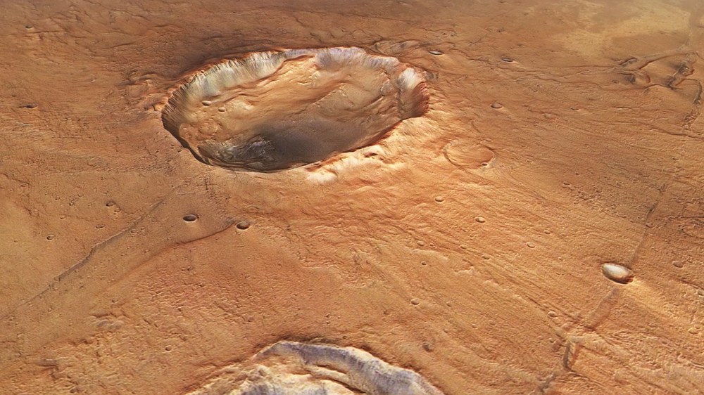
Slightly oval crater with ejecta in the shape of butterfly wings
This perspective view shows a crater in the Idaeus Fossae region on Mars, which is slightly elliptical with diameters of 20 kilometres and 15 kilometres. This distinguishes it from the mostly circular impact craters on the surfaces of Earth-like planets with solid crusts. This suggests an impact at a shallow angle of five to ten degrees relative to the surface. The ejecta material is predominantly deposited on both sides of the crater, transverse to the direction of flight. This is reminiscent of the shape of butterfly wings.
This perspective view shows table mountains (mesas) approximately one thousand metres high in the south of the Idaeus Fossae region. They are remnants of the surrounding Martian highlands, most of which have been eroded by high-energy water flows. Just a few kilometres further south lies the delta at the mouth of Kasei Valles – one of the largest drainage systems on Mars. In the early history of the planet, large quantities of water were carried with tremendous energy from the largest valley complex in the Martian highlands into the lowland plain Chryse Planitia. The image spans approximately 40 kilometres.
Regional overview map of a transition zone from the Martian highlands to the lowlands
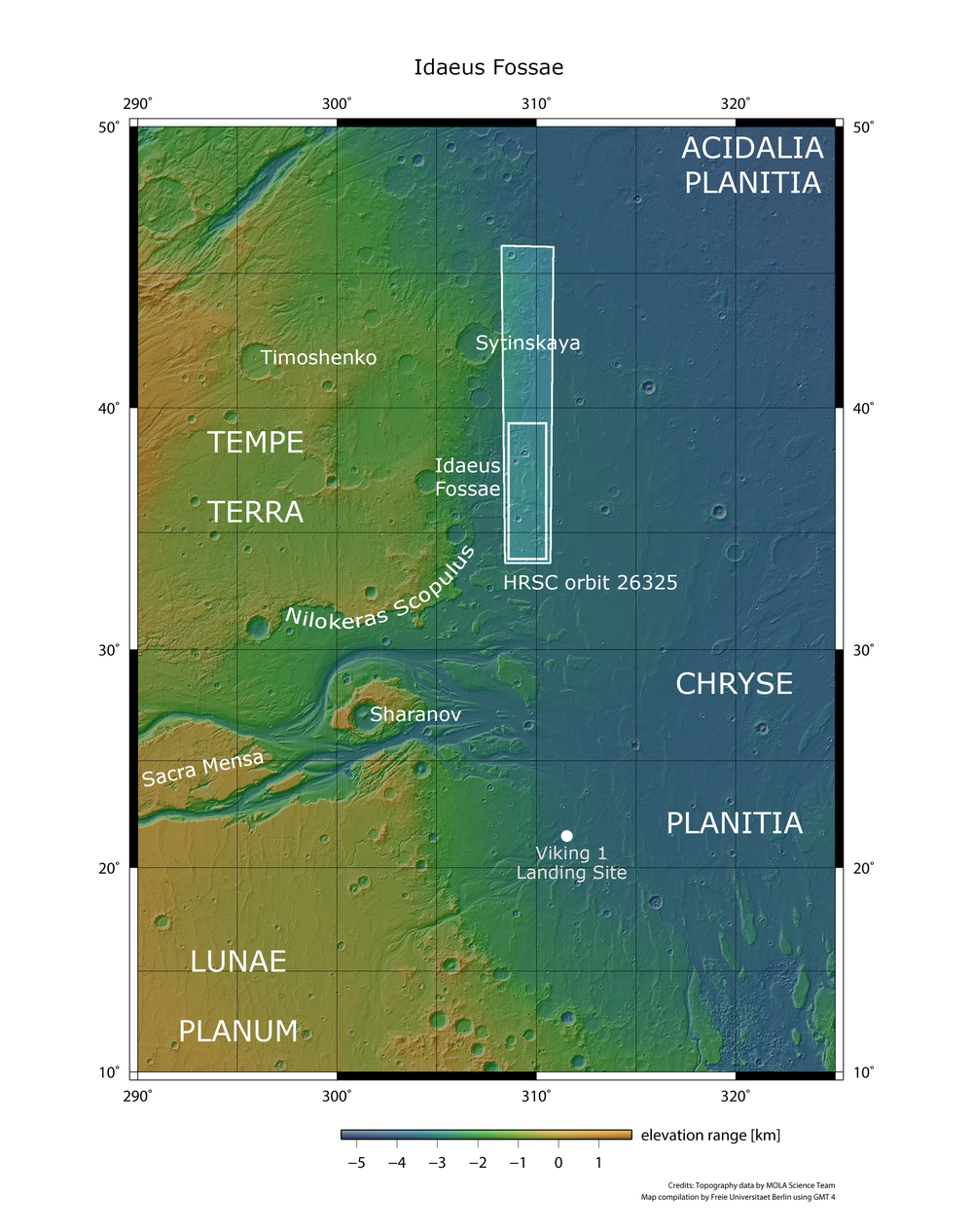
This area is located in the north-western tip of the ‘Golden Plain’ known as Chryse Planitia. This lowland plain is one of the most studied regions on Mars, as one of the most geologically interesting. It lies almost two and a half kilometres below the surrounding Martian highlands, making it one of the lowest-lying areas on Mars. Several large valley systems and outflow channels flow from the highlands into Chryse Planitia, where the erosive power of water has significantly shaped the landscape visible today. This was the main reason why NASA's Viking 1 probe landed there in July 1976 – followed by Mars Pathfinder, the first Mars rover, in 1997. ESA's Mars Express probe recorded a swath approximately 500 kilometres long, from the southern half of which (the small rectangle) the scenes shown here are taken.
Image: 7/7, Credit:
NASA/JPL (MOLA); FU Berlin
New images from DLR's HRSC Mars camera show a region between the Tempe Terra highlands and the lowland plains Acidalia Planitia and Chryse Planitia.
The image is dominated by mostly flat terrain, several dark-edged table mountains and an unusually shaped impact crater.
An anniversary is approaching: in 1976, the Viking lander touched down in western Chryse Planitia.
Focus: Space, exploration, Mars, HRSC
Recently processed images captured by the High-Resolution Stereo Camera (HRSC) reveal a distinctive type of crater in the lowlands of Mars' northern hemisphere. Developed by DLR, the camera experiment on ESA's Mars Express mission has been in operation since January 2004. Researchers are using the image data to generate high-resolution digital terrain models and a global topographic map, providing valuable insights into the origin and development of our neighbouring planet.
The images show an area between the Tempe Terra highlands and the lowland plains of Acidalia Planitia and Chryse Planitia. Nearby lies Idaeus Fossae – a complex system of linear, branching troughs or channels. Just a few kilometres further southwest, the Kasei Valles outflow channel emerges. At 1600 kilometres in length, this is one of the largest dried-up outflow systems on Mars.
Also close by, south of the mouth of the Kasei Valles estuary and the area depicted here (see regional overview), is the landing site of NASA's Viking 1 mission – the first probe to successfully conduct experiments on the planet over a long period of time.
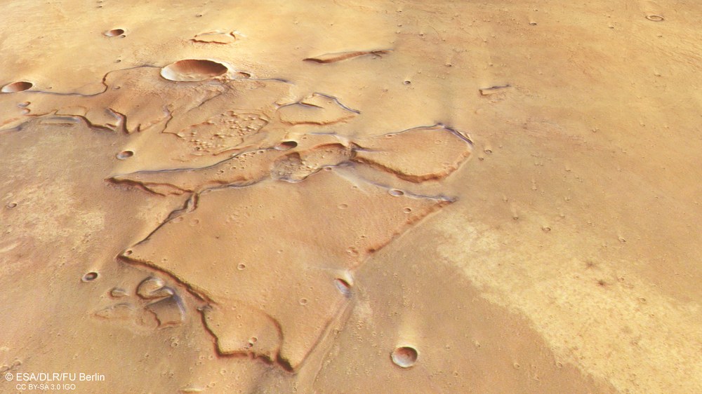
Striking landscape features in Idaeus Fossae
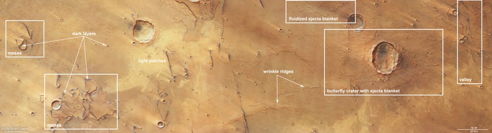
At first glance, the Idaeus Fossae region in the north-western tip of the 'Golden Plain' Chryse Planitia, at the transition from the Martian highlands to the northern lowlands, appears monotonous. On closer inspection, however, interesting landforms can be recognised. From south (left) to north, these include: table mountains (mesas) more than a thousand metres high; layers of dark deposits (dark layers); strikingly bright areas (light patches); wrinkle ridges formed by folding and thrusting as lava cools; fluidised ejecta blankets at impact craters; a crater almost 1500 metres deep with an asymmetrical ejecta blanket (butterfly crater with ejecta blanket); and a valley that was probably formed through extensional tectonics.
Large, high-energy water flows shaped the lowlands
On 20 July 1976, the Viking lander touched down in the west of the Chryse Planitia plain. The arrival had originally been scheduled for 4 July, US Independence Day, but the first images from the Viking 1 orbiter revealed a large concentration of boulders at the chosen landing site. Given the landing risk, NASA spent ten days searching for a more suitable site. Their caution and patience paid off: Viking 1 remained operational until the end of 1982.
A few kilometres southwest of the HRSC images, the 'dichotomy boundary' between the southern Martian highlands and the northern plains appears as a striking, steep escarpment with a two-kilometre drop. Known as Nilokeras Scopulus, it is located at the mouth of the large Kasei outflow channel.
Standing at the top of its edge would offer a view reminiscent of the Grand Canyon, the difference being that the Martian cliff is almost twice as long and much wider. The opposite slope, beyond the 100-kilometre-wide Sharanov crater, would be barely visible on the horizon. The steep escarpment was probably formed by a combination of tectonic faulting and erosion caused by extremely large masses of water rushing through Kasei Valles over a very short period of time.
The image is dominated by predominantly flat terrain dotted with dark-edged table mountains, mesas, and an unusually shaped impact crater. The reddish-brown surface gradually gets darker from south (left in the 'bird's eye' view) to north (right). Several lighter, slightly lower-lying areas are scattered across the image. Together with the linear valleys, they form part of a larger geological structure known as Idaeus Fossae – a system of valleys that lies just a few kilometres west of the highlighted image section.
Virtual flight over the Idaeus Fossae region on Mars.
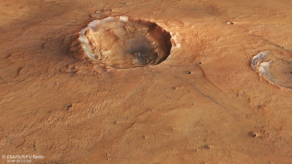
Crater in the Martian region Idaeus Fossae
Your consent to the storage of data ('cookies') is required for the playback of this video on Quickchannel.com. You can view and change your current data storage settings at any time under privacy.
Crater in the Martian region Idaeus Fossae
Virtual flight over the Idaeus Fossae region on Mars.
Credit:
ESA/DLR/FU Berlin
Impact of a shallow-incoming asteroid
On the northern (right-hand) side of the image, an elliptical impact crater stands out. It measures approximately 20 kilometres from east to west and 15 kilometres from north to south. While primary impact craters produced by bodies striking the solid surface of planets in the Solar System are almost always circular, the elliptical shape of this crater suggests an impact at a shallow angle in relation to the surface. Laboratory experiments with high-speed projectiles have shown that impact craters take on an elliptical form when the impact angle is below 15 degrees. At extremely shallow angles of five to ten degrees, 'butterfly craters' are formed.
In such cases, ejecta are mainly deposited on both sides of the crater at a right angle to the direction of flight. In the example shown here, the two 'butterfly wings' are arranged north and south of the crater. To the east and west – along the projectile's flight path – no ejecta was deposited due to the ballistic geometry of the impact.
The ejecta blanket also shows characteristics of liquefied material, which forms when impact debris mixes with subsurface water or ice. Due to the high energy released in such an event, ice liquefies immediately. Even typically rigid, solid rock then behaves like a viscous liquid. Such ejecta formations often display overlapping layers and a clearly rounded outer margin (visible in the top right of the image).
Image processing
These images were acquired by the HRSC (High Resolution Stereo Camera) on 8 November 2024 during Mars Express orbit 26,325. The ground resolution is approximately 17 metres per pixel and the images are centred at approximately 37 degrees north and 309 degrees east.
The colour image combines data from the nadir channel, which looks straight down onto the Martian surface, and the HRSC colour channels.
The oblique, perspective view uses the digital terrain model (DTM), nadir channel and the HRSC colour channels. The anaglyph image, which produces a three-dimensional impression of the landscape when viewed with red-blue or red-green glasses, was derived from the nadir channel and one stereo channel. The colour-coded topographic view is based on a digital terrain model of the region.
The High Resolution Stereo Camera (HRSC) was developed at the German Aerospace Center (DLR) and built in cooperation with industrial partners (Airbus, Lewicki Microelectronic GmbH and Jena-Optronik GmbH). The science team, led by Principal Investigator (PI) Daniela Tirsch from the DLR Institute of Space Research (previously: Planetary Research), consists of 50 co-investigators from 35 institutions and 11 nations. The camera is operated by the DLR Institute of Space Research in Berlin-Adlershof.
