Shaped by wind, water and ice – the Deuteronilus Cavus depression on Mars
May 21, 2025 | Mars Express mission
Shaped by wind, water and ice – the Deuteronilus Cavus depression on Mars
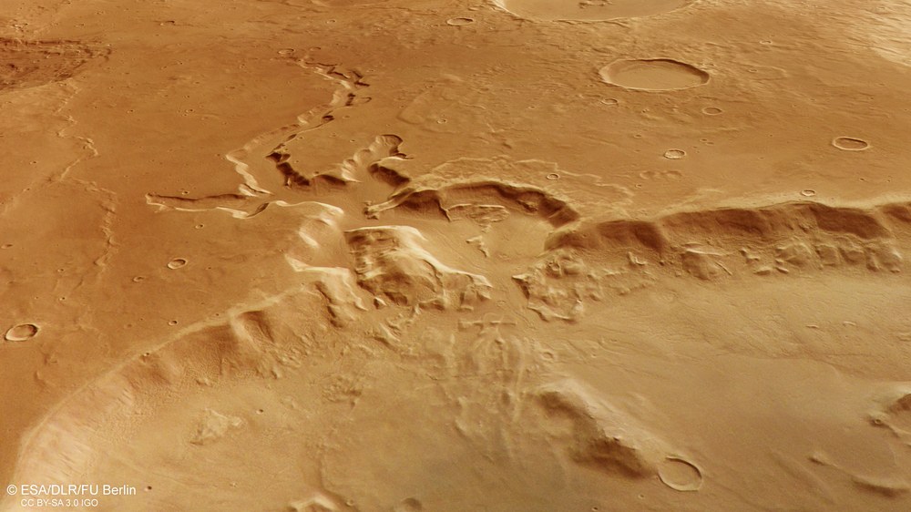
Water, ice and gravity 'gnaw' at the rim of Deuteronilus Cavus
Deuteronilus Cavus is a depression approximately 120 kilometres wide and over 2000 metres deep, located at the transition from the southern Martian highlands to the northern lowlands. It formed more than three and a half billion years ago from an asteroid impact. Since then, numerous geological processes have altered the crater, such as groundwater that emerged from the crater walls and, as seen in this image, eroded valleys into the surrounding highland. The resulting material was deposited within the depression ('Cavus') as a consequence.
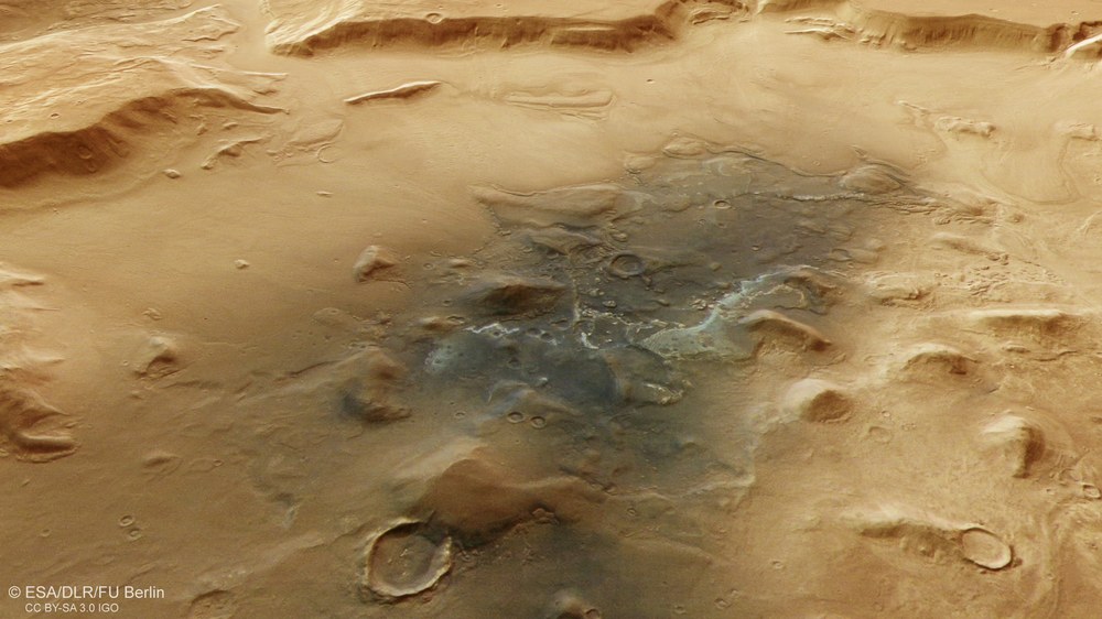
Volcanic dust and eroded hills in Deuteronilus Cavus
The landscape within the over two-kilometre-deep depression of Deuteronilus Cavus consists of a mix of hills, mesas (table mountains) and plains, some of which are surrounded by debris deposits. Also striking is the darker surface material in the centre of the depression, which likely consists of wind-blown sands. The minerals it contains confirm that the dark material is volcanic in origin.
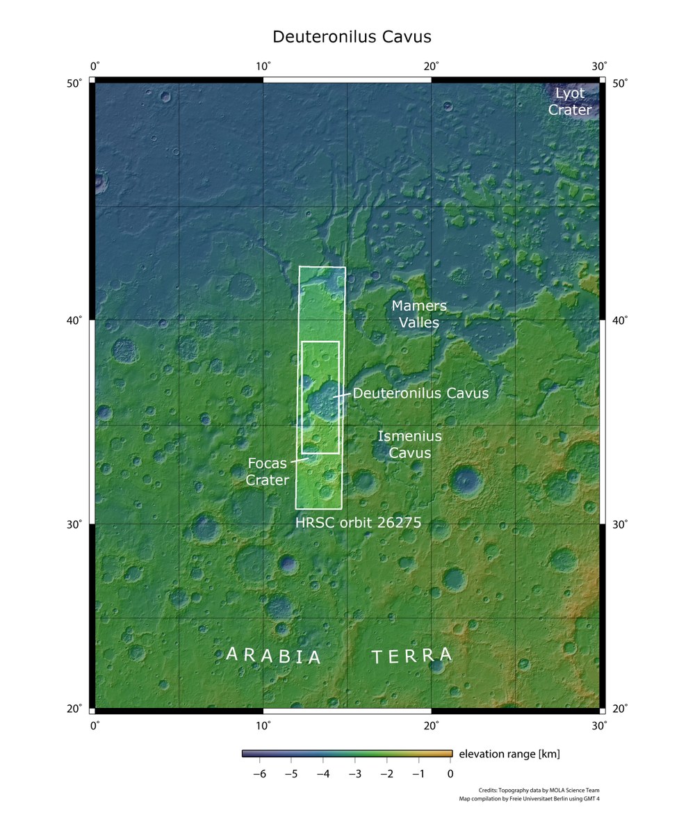
Topographic overview map showing the location of Deuteronilus Cavus
With a diameter of approximately 120 kilometres, the Deuteronilus Cavus depression – formed by an asteroid impact – is about half the size of Earth's largest impact structure, the Sudbury Basin in Canada. Deuteronilus Cavus lies in the northern part of the Arabia Terra highland region, near the boundary with Mars' northern lowlands. The landscapes shown in this publication are located within the rectangular section of the HRSC image from Mars Express orbit 26,275, acquired on 25 October 2024 from an altitude of approximately 300 kilometres.
Image: 7/7, Credit:
NASA/JPL/USGS (MOLA)/FU Berlin (CC BY-SA 3.0 IGO)
The Deuteronilus Cavus impact crater has undergone several transformations since its formation 3.7 to 3.9 billion years ago
These changes have produced landforms typical of the transitional zone between Mars' southern highlands and northern lowlands
Focus: Mars, Mars Express mission, spaceflight
They couldn't be more different, yet they share the same name: the longest river in Africa and a vast crater on Mars. 'Deutero-Nilus', Greek for 'second Nile', was formed by the impact of an asteroid some 3.7 to 3.9 billion years ago. Water and ice – alongside other processes – played a major role in its subsequent evolution. Nearby is also the 'first Nile', Protonilus.
Evidence of this complex geological history is evident from image data captured by the High Resolution Stereo Camera (HRSC) on board ESA's Mars Express orbiter mission. HRSC is a camera experiment developed and built by the German Aerospace Center (Deutsches Zentrum für Luft- und Raumfahrt; DLR) in collaboration with German industry and operated by the DLR Institute of Space Research.
River valleys from the southern highlands to the northern lowlands
Deuteronilus Cavus is a roughly 120-kilometre-wide depression located in the Ismenius Lacus quadrangle of Mars, in the northern part of Arabia Terra – an expansive highland region approximately 2000 kilometres north of the Martian equator. The area is also crossed by the extensive Mamers Valles valley system – a former river network that inspired the name 'second Nile' for the neighbouring depression. Stretching over a thousand kilometres, it runs from the southern highlands into the northern lowlands of our planetary neighbour. The Deuteronilus region is a transitional zone between highlands and lowlands, characterised by small hills, mesas (table mountains), branching channels and troughs that often show flow-like features.
Deuteronilus Cavus has a rich geological history in which surface processes significantly reshaped the original terrain. The near-circular shape of the depression suggests it is a crater formed by a massive asteroid impact, most likely during the Noachian period (4.1 to 3.7 billion years ago). In the subsequent Hesperian and Amazonian periods (beginning more than three billion years ago), rivers and glaciers substantially altered the original crater, nearly doubling its size.
Lava flows and wind also shaped the landscape
The area surrounding the depression also presents a diverse landscape – small and large craters (such as the 75-kilometre-wide Focas crater in the southwest, visible on the right in the overhead image) and wrinkle ridges are prominent features. The latter indicate lava flows that cooled and contracted. While the surrounding terrain dates back to the Noachian period, the depression itself shows multiple features indicating more recent geological activity. HRSC images reveal that parts of the crater rim have been eroded. Particularly in the southern part of the depression, branching channels are visible, likely formed by groundwater seeping to the surface.
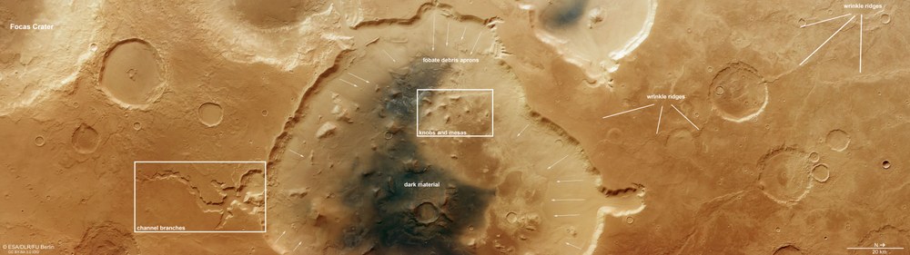
Surface features in the Deuteronilus Cavus depression
The transition zone between the southern highlands and northern lowlands on Mars is shaped by many different geological processes. Notably, at the edge of the 120-kilometre-wide Deuteronilus Cavus depression are deep incised valleys, formed by regressive erosion caused by groundwater emerging from the crater walls. Hills and mesas within the depression may be remnants of a once-continuous highland plain, or possibly formed from the rebound of the Martian crust following the impact of the approximately 10-kilometre asteroid that formed the crater. Arrows in the image show the direction of material movement from slope failures. 'Wrinkle ridges' are hardened flow fronts of low-viscosity lava.
Flow patterns are visible along almost all segments of the crater wall. These structures are often interpreted as 'lobate debris aprons' (rocky glaciers) composed of ice-rich material, covered by a protective layer of rock. As the ice sublimates (evaporates) into the atmosphere, debris deposits remain, preserving the flow patterns created as the glacier moved under its own weight. These are typical landforms found in Mars' mid latitudes.
It is believed that these features date back to the Amazonian period, when the tilt of Mars' rotational axis was greater and these regions were more shaded from the Sun. The resulting climatic conditions allowed ice to accumulate even in the mid latitudes, not just near the poles. HRSC has captured many such glacial features near the equator, including in the Nereidum Montes.
Origins of the hills and mesas unclear
In the centre of the depression, the landscape features a mix of hills, mesas and flat plains, partially surrounded by debris deposits. The smaller hills and mesas may be remnants of a formerly continuous surface that has gradually eroded – leaving behind these 'island mountains'. Another explanation is that they are the remains of a former central peak that formed in some craters as the ground rebounded plastically after the asteroid impact.
In the centre of the depression, darker surface material is visible – likely wind-blown sand. The minerals it contains confirm that the dark material is volcanic in origin. Spectral analysis of the brighter deposits on the crater floor also revealed layered silicates – clay minerals typically formed by the alteration of volcanic ash or rock in the presence of water. This provides further evidence that water once played a formative role in this region.
Image processing
The images were acquired by the HRSC on 25 October 2024 during Mars Express orbit 26,275. The ground resolution is approximately 18 metres per pixel, and the image is centred at approximately 14 degrees East and 36 degrees North. The colour image was created using data from the nadir channel, the field of view aligned perpendicular to the Martian surface, and the HRSC's colour channels. The oblique perspective view was generated from the digital terrain model, the nadir channel and the colour channels. The anaglyph image, which offers a 3D impression of the landscape when viewed with red/blue or red/green glasses, was created using the nadir and one stereo channel. The colour-coded topographic view is based on a digital terrain model (DTM) of the region, which allows the topography of the landscape to be derived. The elevation values in the legend (top right) are referenced to a planetary ellipsoid.
Map server
To download the released raw images and DTMs of the region in GIS-compatible formats, follow this link to the map server
The High Resolution Stereo Camera was developed at the German Aerospace Center (DLR) and built in cooperation with industrial partners (EADS Astrium, Lewicki Microelectronic GmbH and Jena-Optronik GmbH). The science team, led by Principal Investigator (PI) Daniela Tirsch, consists of 50 co-investigators from 35 institutions across 11 nations. The camera is operated by the DLR Institute of Space Research in Berlin-Adlershof.
